Cartwright Air Station, Labrador in 1964-1965
Jan 16, 2021 23:17:06 #

Cartwright Air Station, Labrador in 1964-1965
In the 1960s and 1970s, the USA and Canada had a joint project called the Pine Tree Line that provided long-range radar coverage of the Atlantic Ocean. Some of the stations were manned by Canadians, and others by USAF personnel. One of them, Cartwright Air Station, was located on Sandwich Bay near the town of Cartwright (hence its name). I was assigned there from March 1964 through March 1965 as the Radar Maintenance Officer. In the 1980s the site was razed and very little of the original structures still exist. This set will cover what it was like in 1964-1965. You will note that most of the buildings are connected by enclosed, heated walkways. One could spend an entire year there and never go outside—but most men did go out occasionally—we had Arctic clothing for that purpose.
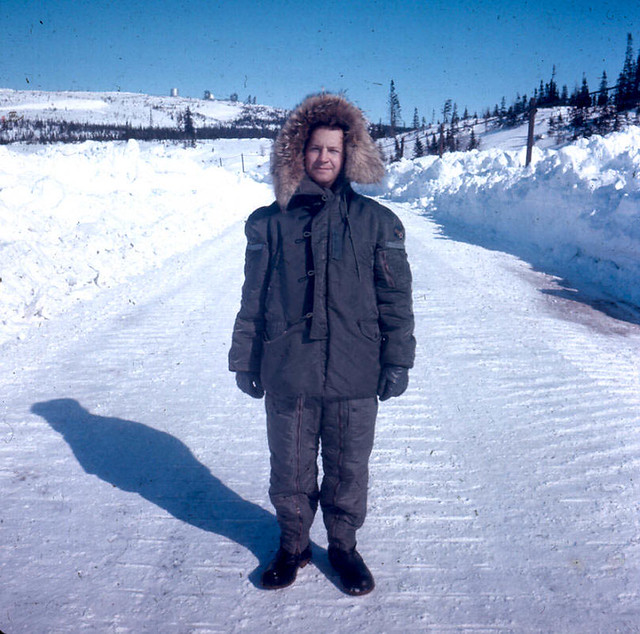
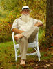
CartwrightMeInParkaMar64.jpg by David Casteel, on Flickr (Me in a parka, Mukluks, etc. with snow, on the road to town)
Aerial view

196405dd Approaching Cartwright AS.jpg by David Casteel, on Flickr (My first view, coming in by helicopter)

196409r-18.jpg by David Casteel, on Flickr (better view of the site)
Exterior views

196406dd looking WSW from FPS-20 tower.jpg by David Casteel, on Flickr (from the FPS-20 radar tower toward town)

196406dd looking WNW from FPS-20 tower.jpg by David Casteel, on Flickr (from the FPS-20 tower toward the ocean)

196406dd view SSW from FPS-20 tower.jpg by David Casteel, on Flickr (pretty little lake near the site)

196408dd Flagpole and cannon.jpg by David Casteel, on Flickr (Motor Pool building, with flagpole and cannon—cribbed from a town memorial)

196405dd View east across site.jpg by David Casteel, on Flickr (from the access road out of town)

196501r-18.jpg by David Casteel, on Flickr (radomes at night, with heat lamps on inside)

196406dd FPS-20 looking west.jpg by David Casteel, on Flickr (the FPS-20 search tower from the FPS-90 height-finder tower)

196406dd ladder on FPS-90 tower.jpg by David Casteel, on Flickr (looking down the ladder of the FPS-90 tower)
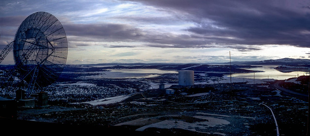
196406dd Panorama--Sandwich Bay at dusk.jpg by David Casteel, on Flickr (Sandwich Bay at dusk)

Helicopter4b.jpg by David Casteel, on Flickr (resupply helicopter, with site beneath)

196501dd new Gym and Rec Bldg.jpg by David Casteel, on Flickr (Gymnasium/Rec Building, showing construction on stilts)
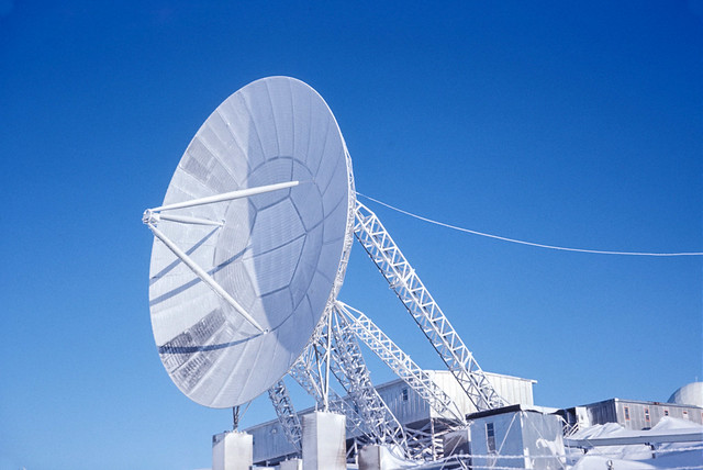
196501dd 60' antenna iced over.jpg by David Casteel, on Flickr (one of the four 60’ diameter Troposcatter communications antennae, covered in ice)
Interior view

196406-02 David in Dining Hall.jpg by David Casteel, on Flickr (a very young ME in the Dining Hall)
In the 1960s and 1970s, the USA and Canada had a joint project called the Pine Tree Line that provided long-range radar coverage of the Atlantic Ocean. Some of the stations were manned by Canadians, and others by USAF personnel. One of them, Cartwright Air Station, was located on Sandwich Bay near the town of Cartwright (hence its name). I was assigned there from March 1964 through March 1965 as the Radar Maintenance Officer. In the 1980s the site was razed and very little of the original structures still exist. This set will cover what it was like in 1964-1965. You will note that most of the buildings are connected by enclosed, heated walkways. One could spend an entire year there and never go outside—but most men did go out occasionally—we had Arctic clothing for that purpose.
CartwrightMeInParkaMar64.jpg by David Casteel, on Flickr (Me in a parka, Mukluks, etc. with snow, on the road to town)
Aerial view
196405dd Approaching Cartwright AS.jpg by David Casteel, on Flickr (My first view, coming in by helicopter)
196409r-18.jpg by David Casteel, on Flickr (better view of the site)
Exterior views
196406dd looking WSW from FPS-20 tower.jpg by David Casteel, on Flickr (from the FPS-20 radar tower toward town)
196406dd looking WNW from FPS-20 tower.jpg by David Casteel, on Flickr (from the FPS-20 tower toward the ocean)
196406dd view SSW from FPS-20 tower.jpg by David Casteel, on Flickr (pretty little lake near the site)
196408dd Flagpole and cannon.jpg by David Casteel, on Flickr (Motor Pool building, with flagpole and cannon—cribbed from a town memorial)
196405dd View east across site.jpg by David Casteel, on Flickr (from the access road out of town)
196501r-18.jpg by David Casteel, on Flickr (radomes at night, with heat lamps on inside)
196406dd FPS-20 looking west.jpg by David Casteel, on Flickr (the FPS-20 search tower from the FPS-90 height-finder tower)
196406dd ladder on FPS-90 tower.jpg by David Casteel, on Flickr (looking down the ladder of the FPS-90 tower)
196406dd Panorama--Sandwich Bay at dusk.jpg by David Casteel, on Flickr (Sandwich Bay at dusk)
Helicopter4b.jpg by David Casteel, on Flickr (resupply helicopter, with site beneath)
196501dd new Gym and Rec Bldg.jpg by David Casteel, on Flickr (Gymnasium/Rec Building, showing construction on stilts)
196501dd 60' antenna iced over.jpg by David Casteel, on Flickr (one of the four 60’ diameter Troposcatter communications antennae, covered in ice)
Interior view
196406-02 David in Dining Hall.jpg by David Casteel, on Flickr (a very young ME in the Dining Hall)
Jan 16, 2021 23:38:08 #
Cool - I was in Cartwright, Hopedale and Saglek supporting offshore drilling operations during the 70s. Until I flew in there, I had no idea that these stations existed. Not much left now except that they are still cleaning up the mess left by the equipment that was dumped in the sea...
Nice to see how it looked when it was fully operational. Thanks for sharing.
Nice to see how it looked when it was fully operational. Thanks for sharing.
Jan 16, 2021 23:47:42 #
Ourspolair, thanks for your commentary. You're welcome. The concrete support structure of the old FPS-20 search radar still stands (1 story) and there are some concrete pads where buildings and antennae had existed. In 2005 the town had a week-long celebration and 7 of the former USAF troops who had served there made the trip for that. We affixed a bronze plaque to the interior of that concrete skeleton commemorating our service there. Quite a few of the old buildings in town had significant degradation.
Jan 17, 2021 00:01:51 #
way cool! my first posting was to the "flug barrak" at Kitzigen West Germany in the late 70s... the runway had been built by the nazis and was huge ... not sure if they still use the air field (i was in a tank battalion) ... we turned it over to the Germans a while ago.
Jan 17, 2021 00:07:38 #
Jan 17, 2021 00:31:31 #
MSW, thanks for your nice comment. It would be interesting to investigate the current status of that airfield.
rmalarz, thanks for you compliment. I'm glad you enjoyed them.
rmalarz, thanks for you compliment. I'm glad you enjoyed them.
Jan 17, 2021 00:34:46 #

Oh those Mickey Mouse cold weather boots bring back memories, David! Many cold times in Grafenwher.
Jan 17, 2021 00:37:24 #

Jan 17, 2021 05:59:08 #
compilot
Loc: ARIZONA
Thanks for posting these images. I was an Air Force radar operator from 1962 to 1971, first assignment was K.I. Sawyer AFB, Mi. Some Pine tree radars were controlled by our SAGE (Semi-Automatic Ground Environment) unit from our "Block House" at K.I. I do not remember this unit, I might recognize the call sign but not the station name. I feared being assigned to one of those super cold locations, K.I. was cold enough.
Jan 17, 2021 06:10:55 #
MSW wrote:
way cool! my first posting was to the "flug barrak" at Kitzigen West Germany in the late 70s... the runway had been built by the nazis and was huge ... not sure if they still use the air field (i was in a tank battalion) ... we turned it over to the Germans a while ago.
Great images!!! David
Jan 17, 2021 07:05:15 #
Thanks for sharing this, you'll were the front lines defense against threats from the east in those days. I remember the fears of attacks from Russia. We had nuclear bomb attack drills in school during the 60's.
Jan 17, 2021 07:13:12 #
Great photos of an era!Eareckson Air Station (IATA: SYA, ICAO: PASY), formerly Shemya Air Force Base, is a United States Air Force military airport located on the island of Shemya, in the Alaskan Aleutian Islands. It was the west version of your mission.
Jan 17, 2021 08:39:57 #

Jan 17, 2021 08:48:55 #

Thank you for posting these David. I hope somewhere there is a “history” of this era, and sites like these. Just a couple of years after you were there, our group of cadets visited Goose Bay, Labrador, where the US had a fighter-interceptor squadron to respond to what your radars would pick up coming over the pole. Your post brought back those memories. JimR
Jan 17, 2021 09:57:50 #
DougS
Loc: Central Arkansas
Interesting, and informative set. Thanks for sharing your memories, and your service!
How cold did it get while you were there? I know it hurts to just breathe at -35 F...
How cold did it get while you were there? I know it hurts to just breathe at -35 F...
If you want to reply, then register here. Registration is free and your account is created instantly, so you can post right away.