Photo Tour of the Southwest
Nov 13, 2023 10:23:24 #

We are taking two months starting around Christmas to do a photo tour of the SW. Our route will take us from Northern AL through MS and LA into Ft. Worth for Christmas Eve and day. From there we will head to the SE part of NM - spend a week or so in western and southwestern NM(I have already captured the central and northwest part of the state). Next on the list is AZ and Page. I want to capture Antelope Canyon, but since they no longer allow photo tours is Canyon X a viable and worthy alternative since you can book a guide and use a tripod? The You Tube videos I have watched(at least the ones by and for photographers) are not high on the Lower and Upper Canyons. Since we will be there around the mod to latter part of January, the crowds will be smaller but input from those of you who have photographed that area would be most appreciated.
Any other "do not miss" locations are also welcomed.
Thanks so much in advance...this community is always so helpful and gracious.
Any other "do not miss" locations are also welcomed.
Thanks so much in advance...this community is always so helpful and gracious.
Nov 13, 2023 11:32:07 #
Hoops12751 wrote:
We are taking two months starting around Christmas... (show quote)
Canyon x has onky one very small slot that is equivalent to Antelope but it is very nice. If you can hike you might consider looking at a tour of both Cardiac Canyon and Canyon X. At least a few years ago they would let you do both on the same trip. Cardiac Canyon isnt as narrow but it is photographic. One oortion of the canyon involves climbing a rope ladder but it can be skipped and it is pretty steep getting down into it but its not a bad hike. They end at Canyon x.
Best part of both canyons is not only do they alkow tripods they let you explore some of it on your own.
With that said if hou have time i would consider also doing at least one of the Antelope canyon tours. Even though you cant get a photo tour and its crowded you can still get some bice shots looking up above the crowd.
Nov 13, 2023 11:36:13 #
Nov 13, 2023 11:56:01 #

Hoops12751 wrote:
We are taking two months starting around Christmas... (show quote)
I've done a month-long 'circle' of Albuquerque > Grand Canyon, Tucson, south New Mexico and back up to ALQ to fly back to Chicago. I took a private tour of Canyon de Chelly between X-mas and NYE on the morning / day after 4-inches of snow. It was a great trip, below is a list of places to consider as you map your travels and dates:
Santa Fe, NM
Farmington, NM / Shiprock / Aztec Ruins National Monument
Mesa Verde NP
Monument Valley
Four Corners Monument
Canyon de Chelly
Petrified Forest NP
Grand Canyon NP
Holbrook, AZ and Route 66
Organ Pipe National Monument
Tucson Mountain Park
Saguaro NP
Pima Air & Space Museum (requires advanced reservation)
White Sands NP
NRAO Very Large Array (those huge white radio telescopes)
Bosque del Apache NWR (sandhill cranes)
Nov 13, 2023 12:06:49 #

CHG_CANON wrote:
I've done a month-long 'circle' of Albuquerque >... (show quote)
I would have “Chaco Canyon” on my ‘do not miss list’. I’ve been there twice, once as a GradStudent, and once with our daughters. The locals say the authorities keep the road there primitive to keep crowds down, but the 25 mile drive is worthwhile. The place was central to the Pueblo culture at one time. I believe it was the first US location on the international cultural heritage list {with places like the Pyramids}.
Nov 13, 2023 12:16:43 #

Although Antelope Canyon doesn't have photo tours anymore, it is no big deal. I visited w/o a photo tour and got all the great photos I needed.
Nov 13, 2023 12:50:18 #

I heartily recommend consulting Sandra Hinchman's "Hiking Southwest Canyon Country." She's not a photographer, but she seems to have been almost everywhere in the area, and describes the sights in considerable detail. Reading this book introduced me to the area, and using it as my guide has been very rewarding over the years.
Amazon has it here: https://www.amazon.com/Hiking-Southwest-Canyon-Country-Hinchman/dp/1680511467/ref=sr_1_18?keywords=southwest+tours&qid=1699897567&sr=8-18
Amazon has it here: https://www.amazon.com/Hiking-Southwest-Canyon-Country-Hinchman/dp/1680511467/ref=sr_1_18?keywords=southwest+tours&qid=1699897567&sr=8-18
Nov 13, 2023 13:06:44 #
larryepage
Loc: North Texas area
Hoops12751 wrote:
We are taking two months starting around Christmas... (show quote)
Good morning. And thank you for planning to visit our state. Keep in mind that January (and February) are our two most variable months of the year weather-wise. High temperatures will range from 32 degrees to 75 degrees, and low temperatures will be somewhere between 5 and 45. It will be colder as you go west and the elevation increases, and a lot colder as you go north, even though there is less elevation change. Going from Fort Worth to Amarillo is a whole different project than going from Fort Worth to Midland.
Having given that caution, most of the landscape along the most feasible routing from Fort Worth to the west is mostly flat, open country with a few hills here and there. I-20 passes through ranch land, then farm land, then semi-arid prairie on the way to Big Spring or Midland, but either of those can be a jumping off point to Carlsbad Caverns. A more northern route, to Wichita Falls, then to Lubbock or Amarillo, would be more interesting, but there is still a lot of fairly repetitious open space. There are some scenic canyons (on the White River, for instance) and the Caprock Escarpment a short time before getting to Lubbock or Amarillo, but you may find them too subtle for photography.
You might want to consider a detour to the South toward San Antonio and the Hill Country. It will be winter, to green landscapes will be limited, except where there is live oak or cedar, but these are historic areas that are important to us as natives. San Antonio ("SA") offers a number of missions, including the Alamo. Fredericksburg is a German tourist town that mostly avoids being touristy. A must-do there is the Museum of the Pacific War, which was originally a museum dedicated to Admiral Chester Nimitz.
I am not an expert on the Houston area, but there is a Natural History museum there whose collection rivals that of the Smithsonian. There are also a number of historical sites there, as well. The climate there is also going to be more temperate. You can head west from there on I-10, but may need to work you way a little bit north, depending on where you want to go next.
Carlsbad Caverns is just off US 180, which parallels north of I-20. They have been doing a lot of work on their lighting over the past few years, and I think they have standardized on 4000K LED lighting in most areas. That makes photography a lot easier, especially if your camera has Anti-Flicker. There are probably still some exceptions, especially in areas that the bats fly through. It's ben awhile since I've been to CC, and it's #1 on my planning list.
As you go west, the Organ Mountains are just east of Las Cruces, NM. They used to be quite well noted for their pastel colors, although I've not seen images of them much lately. They are good any time, but would be a notable Golden Hour subject. White Sands is just East from the Organ Mountains.
From here, it depends on how far north you go. I-25 will take you to Albuquerque and Santa Fe. Literally tons of stuff there. If you go to Albuquerque, check out the Turquoise Trail, which is an alternative highway on the back (East) side of Sandia Peak.
If you go West, check the NM map and find your way to Santa Rita, site of a monster open-pit copper mine. Not sure that it is still operating, but it is a remarkable hole in the ground. In that same area is City of Rocks State Park is just off US-180 a few miles south of Hurley. It isn't something that I would get in the car and drive to, but it's quite interesting if you are in the area. It is much more developed now than when I used to visit with my mother's favorite uncle.
There are a lot of other choices. My hope is that I've captured a few that others might not mention.
Nov 13, 2023 13:23:42 #
Hoops12751 wrote:
We are taking two months starting around Christmas... (show quote)
I have had to cancel a tour of NM twice because many of the main photography locations are still restricted because of COVID concerns; worth checking out before you finalize your itinerary
Nov 13, 2023 13:50:37 #
I don't think anyone's mentioned:
Big Bend NP (Big variety of terrain and sights, photo, drive, hike. Probably some snow in the mountains.)
Guadalupe NP (more of a hiker's park).
And I second the recommendation of Carlsbad Cavern's NP and Bosque del Apache NWR (fantastic place for wildlife).
Big Bend NP (Big variety of terrain and sights, photo, drive, hike. Probably some snow in the mountains.)
Guadalupe NP (more of a hiker's park).
And I second the recommendation of Carlsbad Cavern's NP and Bosque del Apache NWR (fantastic place for wildlife).
Nov 13, 2023 14:09:15 #
CHG_CANON wrote:
I've done a month-long 'circle' of Albuquerque >... (show quote)
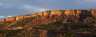
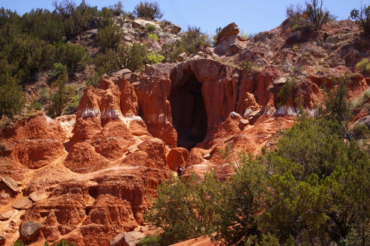
If your route takes you along I-40 through Amarillo, you might want to make a side jog through Palo Duro Canyon, 15 miles to the south.
Fortress Cliffs
Nov 13, 2023 14:37:36 #
Nov 13, 2023 14:43:57 #
Hoops12751 wrote:
We are taking two months starting around Christmas... (show quote)
Bisbee, Tombstone, Ft. Bowie, Tumacacori, SN Xavier, Kitt Peak Observatory, Boyce Thompson Aboretium, Casa Grande ruins, Hall of Flame Fire Museum, Phoenix Zoo, Pueblo Grande Museum, Heritage Square in Phoenix, Lake Pleasant, Copper Museum in Clarkdale, Apache Trail to Roosevelt Dam (An amazing drive), Prescott courthouse and whiskey row, Winslow Western museum and the Hassayampia River (upside down river), Jerome, Oak Creek Canyon, Walnut Canyon, Lowell Observatory, Wupatki National Monument, Grand Canyon, Winslow; all in AZ. Lots more but these are a few places to take wonderful and unique photos.
Nov 13, 2023 15:43:11 #
daf40
Loc: Mesa, AZ
From Monument Valley (a must see) it is only a short drive to Valley of the Gods (spectacular scenery in S. Utah). Heading south, don't miss Sedona, which is as spectacular as any of the national parks. In the Tucson area, also consider Kartchner Caverns or Collossal Caves. Proceding south from Tucson, Chiricahua National Monument is gorgeous. Tombstone and Bisbee are also worth visiting. Arizona is truly an amazing state. So much to see and do, with unbelievable winter weather.
Nov 13, 2023 15:43:19 #
If I were headed to SE New Mexico, I would very much like to check out White Sands NP, particularly if I could get there at or before daybreak, so that I might expect expanses of dunes without footprints.
If you want to reply, then register here. Registration is free and your account is created instantly, so you can post right away.