Italy: Cinque Terra Part 6 - Along The Ligurian Coast
Oct 28, 2023 18:21:18 #

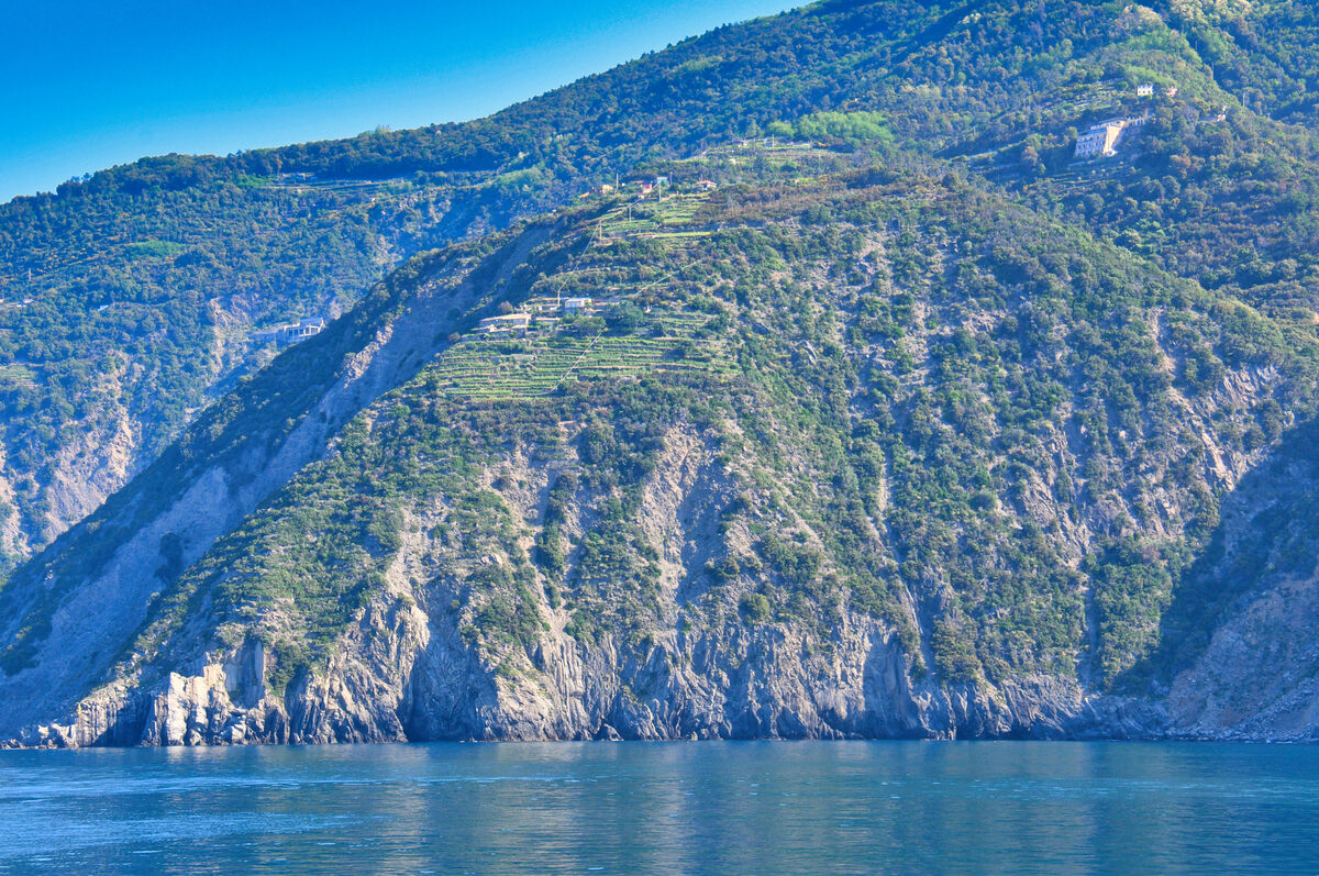
We continued our boat ride from Porto Venere to Monterosso along the rugged Ligurian Coast. We were impressed by the terraced vineyards and houses built on the multicolored hillsides. The morning haze made fo very bland photos which came to life in post processing with Luminar Neo.
The Ligurian Sea (Italian: Mar Ligure; French: Mer Ligurienne; Ligurian: Mâ Ligure; Corsican: Mari Liguru) is an arm of the Mediterranean Sea. It lies between the Italian Riviera (Liguria) and the island of Corsica. The sea is thought to have been named after the ancient Ligures people.
Geography
The sea borders Italy as far as its border with France, and the French island of Corsica. In the east, the sea borders the Tyrrhenian Sea, while in the west it borders the Mediterranean Sea proper. Genoa is the most prominent city in the area. The northwest coast is noted for its scenic beauty and favourable climate.
The Gulf of Genoa is its northernmost part. The ports of Genoa and La Spezia are on its rocky coast. It reaches a maximum depth of more than 2,800 m (9,300 ft) northwest of Corsica.
According to a 1983 study, since 1977 a series of experimental analyses on sea-level variations at Genoa and Imperia highlighted "the existence of a seiche wave with a mean period of 5.8 hours", whose reasons weren't yet explained at that time. The Ligurian Sea was modeled as a rectangular semi-closed basin with a longitudinal length of 40 km (25 mi) and a transversal one of 10 km (6.2 mi), in an average constant depth of 2,000 m (6,600 ft; 1,100 fathoms).
Extent
The International Hydrographic Organization defines the limits of the Ligurian Sea as follows:
On the Southwest. A line joining Cape Corse (Cape Grosso, 9°23′E) the Northern point of Corsica to the frontier between France and Italy (7°31′E).
On the Southeast. A line joining Cape Corse with Tinetto Island (44°01′N 9°51′E) and thence through Tino and Palmaria Islands to San Pietro Point (44°03′N 9°50′E) on the Coast of Italy.
On the North The Ligurian Coast of Italy.
Flowings
The Ligurian Sea is attraversed by the Modified Atlantic Water (MAW) on its surface and by the Levantine Intermediate Water in depth. It is also brushed by the two main currents which surround the Corsica island: the Western Corsica Current and the Tyrrenian current that reaches the Corsica Channel.
Conservation
In order to provide protection for the numerous cetacean (whales and dolphins; porpoises are not found in this part of the Mediterranean Sea) species in the Ligurian Sea the bordering countries established the sea as a SPAMI in 1999. The International Ligurian Sea Cetacean Sanctuary now covers 84,000 km2 (32,000 sq mi) covering territorial waters as well as high sea.
https://en.wikipedia.org/wiki/Ligurian_Sea
For additional images from the drive through La Spezia and Porto Venere, please see my previous posts:
https://www.uglyhedgehog.com/t-789349-1.html#14224070
https://www.uglyhedgehog.com/t-789440-1.html#14226109
https://www.uglyhedgehog.com/t-789648-1.html
https://www.uglyhedgehog.com/t-789843-1.html#14233553
https://www.uglyhedgehog.com/t-789942-1.html
https://www.uglyhedgehog.com/t-790111-1.html
I hope you enjoy these!
Mark

(Download)

(Download)

(Download)

(Download)

(Download)

(Download)

(Download)
(Download)

(Download)

(Download)
Oct 28, 2023 18:22:03 #

Oct 28, 2023 18:22:54 #
srfmhg wrote:
We continued our boat ride from Porto Venere to Mo... (show quote)
Another interesting set and info Mark.


Oct 28, 2023 18:42:07 #

Oct 28, 2023 18:55:16 #
bcheary wrote:
Another interesting set and info Mark.
Thanks very much Brian.
Oct 28, 2023 18:55:36 #
Oct 28, 2023 22:15:21 #

Oct 28, 2023 23:08:23 #
Oct 28, 2023 23:28:00 #
MosheR
Loc: New York City
srfmhg wrote:
We continued our boat ride from Porto Venere to Mo... (show quote)
Mark, this is very different from your other Cinque Terra shots, and just as stunning. I always say that when one sees photos of a place she's visited, she can see around the edges. Your photos have so much depth and subtle coloration that I can almost feel around the edges.
Oct 29, 2023 05:31:39 #

Wonderful set, Mark. Loved seeing the terraced vineyards. Beautifully done.
Oct 29, 2023 05:35:51 #

Oct 29, 2023 06:48:40 #
Oct 29, 2023 07:31:08 #

Oct 29, 2023 08:14:35 #

Oct 29, 2023 09:10:51 #

If you want to reply, then register here. Registration is free and your account is created instantly, so you can post right away.