S & E Asia 91 - Myanmar 31: Mandalay 1 - Intro Mandalay - Sagaing: Umin Thonze Pagoda
Apr 3, 2022 10:37:08 #

So here we are now in MANDALAY, the "CITY OF THE GOLDEN PAGODAS". Interestingly, our visit to this place here is actually made up of the four featured towns/areas of MANDALAY: AMARAPURA, SAGAING and INWA (the ancient town of Ava). While to us this appeared to be all in one area, I was surprised to realize that all the text I found online relating to this area do not treat the area as one but instead cover the individual places separately. This was rather astonishing as from our stay at the hotel, we easily flipped from one location to the next. With the information thus available, I will address these 4 locations separately below.
MANDALAY - (မန္တလေး)
This is after Yangon the second-largest city in Myanmar. Located on the east bank of the Irrawaddy River, 716 km (445 mi) north of Yangon, the city has a population of some 1.3 million. - Mandalay was founded in 1857 by King Mindon, replacing Amarapura as the new royal capital of the Konbaung dynasty. It was Burma's final royal capital before the kingdom's annexation by the British Empire in 1885. Under British rule, Mandalay remained commercially and culturally important despite the rise of Yangon, the new capital of British Burma. The city suffered extensive destruction during the Japanese conquest of Burma in the Second World War. In 1948, Mandalay became part of the newly independent Union of Burma. Today, the city is the economic center of Upper Myanmar and considered the center of Burmese culture. A continuing influx of illegal Chinese immigrants, mostly from Yunnan, since the late 20th century, has reshaped the city's ethnic makeup and increased commerce with China. Despite the present capital Naypyidaw's recent rise, Mandalay remains Upper Burma's main commercial, educational and health center.
Like most former (and present) capitals of Burma, Mandalay was founded on the wishes of the ruler of the day. In February 1857, King Mindon founded a new royal capital at the foot of Mandalay Hill, ostensibly to fulfill a prophecy on the founding of a metropolis of Buddhism in that exact place on the occasion of the 2,400th jubilee of Buddhism. The new capital city site was 66 km² (25.5 sq mi) in area, surrounded by four rivers. The plan called for a 144-square block grid patterned citadel, anchored by a 16 square block royal palace compound at the center by Mandalay Hill. The 1020-acre (413-hectare) citadel was surrounded by four 2,032 m (6,666 ft) long walls and a moat 64 m (210 ft) wide, 4.6 m (15 ft) deep. At intervals of 169 m (555 ft) along the wall, were turrets with gold-tipped spires for watchmen. The walls had three gates on each side, and five bridges to cross the moat. In addition, the king also commissioned the Kuthodaw Pagoda, the Pahtan-haw Shwe Thein Ordination Hall, the Thudamma zayats or public houses for preaching Buddhism and a library for the Pali Canon. For the next 26 years, Mandalay was to be the last royal capital of the Konbaung Dynasty, the last independent Burmese kingdom before its final annexation by the British Empire. Mandalay ceased to be the capital in November 1885 when the British conquered the city, looted the Pitakataik (Royal Library) and sent Thibaw Min and his queen Supayalat into exile, ending the Third Anglo-Burmese War.
AMARAPURA (အမရပူရ]
The name literally means 'The Immortal city', it is a former capital of Myanmar, and now a township of Mandalay city. Amarapura is bounded by the Irrawaddy river in the west and the ancient capital site of Ava (now Inwa) in the south. It was the capital of Myanmar twice during the Konbaung period (1783–1821 and 1842–1859) before finally being supplanted by Mandalay 11 km (6.8 mi) north in 1859.
Amarapura was founded by King Bodawpaya of the Konbaung Dynasty as his new capital in May 1783. The new capital became a center of Buddhist reforms and learning. In 1800, Buddhist clergy from Sri Lanka obtained higher ordination in this city and founded the Amarapura Nikaya (Amarapura sect). In 1810 the town was estimated to contain 170,000 inhabitants, but was in that year destroyed by fire. Bodawpaya's grandson, King Bagyidaw moved the Court back to Ava in November 1821 and in 1827 the population of Amarapura was estimated at only 30,000. Bagyidaw's successor King Tharrawaddy again moved the royal capital back to Amarapura in February 1842.
Amarapura today is part of Mandalay, as a result of urban sprawl. The township is known for its traditional silk and cotton weaving, and for bronze casting. It is a popular tourist day-trip destination from Mandalay. The major sights in Amarapura today are the MAHAGANDHAYON MONASTERY, a large modern complex with hundreds of monks and novices, well known throughout the country, and the U BEIN BRIDGE, a 1.2 km (0.75 mi) wooden footbridge (longest teak bridge in the world) built by the mayor U Bein salvaging the unwanted teak columns from the old palace during the move to Mandalay. We will extensively cover both of these places during my presentation of Mandalay.
SAGAING - (စစ်ကိုင်းမြို့)
This is the former capital of the Sagaing Region of Myanmar. It is located west of the Irrawaddy River, 20 km (12 mi) to the south-west of Mandalay on the opposite bank of the river. Sagaing with numerous Buddhist monasteries is an important religious and monastic center. The pagodas and monasteries crowd the numerous hills along the ridge running parallel to the river. The central Soon U Ponnya Shin Pagoda is connected by a set of covered staircases that run up the 240 m (790 ft) hill. - Today, the city with about 70,000 inhabitants is part of the Mandalay Metropolitain area with more than 1,022,000 inhabitants. The city is a frequent tourist destination. Within the city are six universities.
The classical name of Sagaing is Zeyapura, which literally translates to "City of Victory." - Sagaing was the capital of Sagaing Kingdom (1315-1364), one of the minor kingdoms that rose up after the fall of Pagan dynasty, where one of Thihathu's sons, Athinkhaya, established himself. During the Ava period (1364-1555), the city was the common fief of the crown prince or senior princes. During the reign of King Naungdawgyi. Sagaing briefly became the royal capital between 1760 and 1763. - On 8 August 1988, Sagaing was the site of demonstrations which were concluded by a massacre in which around 300 civilians were killed.
INWA/AVA - (အင်းဝမြို့)
It is also spelled Innwa, formerly known as Ava, and is an ancient imperial capital of successive Burmese kingdoms from the 14th to 19th centuries. Throughout history, it was sacked and rebuilt numerous times. The capital city was finally abandoned after it was destroyed by a series of major earthquakes in March 1839. Though only a few traces of its former grandeur remain today, the former capital is a popular day-trip destination from Mandalay.
The name Inwa literally means "Mouth of the Lake", reflecting its geographical location at the mouth of lakes in the Kyaukse District. Another theory states that it is derived from Innawa, meaning "nine lakes" in the area. The modern standard Burmese pronunciation is Inwa, following the modern orthography. But the local Upper Burmese pronunciation is Awa. Indeed, the spelling of the city in the royal records, all written prior to the modern Burmese spelling standardization drives, is Awa, the phonetic spelling of the Upper Burmese usage. The most common Western transcription Ava comes from Awa via Portuguese.
Inwa was the capital of Burma for nearly 360 years, on five separate occasions, from 1365 to 1842. Inwa was so identified as the seat of power in Burma that it was the name by which Burma was known to Europeans down to the 19th century. Strategically located on the confluence of Irrawaddy and Myitnge rivers, and in the main rice-growing Kyaukse District of Upper Burma, the location of Ava had been scouted as a possible capital site as early as 1310 by King Thihathu. Though Thihathu eventually built his new capital at Pinya a few miles east inland in 1313, Thihathu's great-grandson Thado Minbya, who unified the Sagaing and Pinya kingdoms in September 1364, chose the site of Inwa as his new capital.
Inwa was officially founded in February 1365 on a man-made island created by connecting the Irrawaddy on the north and the Myitnge on the east with a canal on the south and the west. The construction of the artificial island also involved filling in the swamplands and lakes. The brick fortifications of Inwa do not follow the conventions of the earlier rectilinear city plans. Instead, the zigzagged outer walls are popularly thought to outline the figure of a seated lion. The inner enclosure or citadel was laid out according to traditional cosmological principles and provided the requisite twelve gates. - The end of the city came via a natural disaster. Starting on 22 March 1839, the region was hit by a series of earthquakes. The main earthquake hit the region, as far west as Sagaing, the next day, at five o'clock in the morning on 23 March 1839, and many tremors followed for days afterwards. In their wake, the entire region was left in shambles. The capital was hardest hit: everything was leveled; many people and livestock perished. The city was not rebuilt. King Tharrawaddy chose instead to rebuild a new palace in Amarapura, and moved the seat of his government there in February 1842.
-------------------------------------------------------------------------------------------------------------------------------
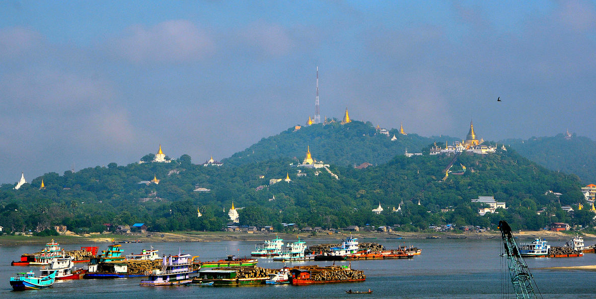
In this first set, we start our visit of the area at the Sagaing Hills, getting a first splendid view of the pagoda-studded hillside from down at the Irrawaddy River, just before the Yadanarbon Bridge that leads us to the hills. The rest of the images shows us inside and outside views of the Umin Thonze Pagoda, one of the major pagodas on the hill.
Notes
TRIP INFO: Set # 1 provides a brief introduction to THIS SERIES on SOUTH & EAST ASIA. See it at
https://www.uglyhedgehog.com/t-724330-1.html
MYANMAR COUNTRY INFO in set # 61: https://www.uglyhedgehog.com/t-731087-1.html
EARLIER POSTS of this series: Access my topic list at UHH, the new posts are listed in reverse chronological order:
https://www.uglyhedgehog.com/user-topic-list?usernum=45105
Thanks for visiting, I recommend viewing the downloads and look forward to your comments and questions.
.
MANDALAY - (မန္တလေး)
This is after Yangon the second-largest city in Myanmar. Located on the east bank of the Irrawaddy River, 716 km (445 mi) north of Yangon, the city has a population of some 1.3 million. - Mandalay was founded in 1857 by King Mindon, replacing Amarapura as the new royal capital of the Konbaung dynasty. It was Burma's final royal capital before the kingdom's annexation by the British Empire in 1885. Under British rule, Mandalay remained commercially and culturally important despite the rise of Yangon, the new capital of British Burma. The city suffered extensive destruction during the Japanese conquest of Burma in the Second World War. In 1948, Mandalay became part of the newly independent Union of Burma. Today, the city is the economic center of Upper Myanmar and considered the center of Burmese culture. A continuing influx of illegal Chinese immigrants, mostly from Yunnan, since the late 20th century, has reshaped the city's ethnic makeup and increased commerce with China. Despite the present capital Naypyidaw's recent rise, Mandalay remains Upper Burma's main commercial, educational and health center.
Like most former (and present) capitals of Burma, Mandalay was founded on the wishes of the ruler of the day. In February 1857, King Mindon founded a new royal capital at the foot of Mandalay Hill, ostensibly to fulfill a prophecy on the founding of a metropolis of Buddhism in that exact place on the occasion of the 2,400th jubilee of Buddhism. The new capital city site was 66 km² (25.5 sq mi) in area, surrounded by four rivers. The plan called for a 144-square block grid patterned citadel, anchored by a 16 square block royal palace compound at the center by Mandalay Hill. The 1020-acre (413-hectare) citadel was surrounded by four 2,032 m (6,666 ft) long walls and a moat 64 m (210 ft) wide, 4.6 m (15 ft) deep. At intervals of 169 m (555 ft) along the wall, were turrets with gold-tipped spires for watchmen. The walls had three gates on each side, and five bridges to cross the moat. In addition, the king also commissioned the Kuthodaw Pagoda, the Pahtan-haw Shwe Thein Ordination Hall, the Thudamma zayats or public houses for preaching Buddhism and a library for the Pali Canon. For the next 26 years, Mandalay was to be the last royal capital of the Konbaung Dynasty, the last independent Burmese kingdom before its final annexation by the British Empire. Mandalay ceased to be the capital in November 1885 when the British conquered the city, looted the Pitakataik (Royal Library) and sent Thibaw Min and his queen Supayalat into exile, ending the Third Anglo-Burmese War.
AMARAPURA (အမရပူရ]
The name literally means 'The Immortal city', it is a former capital of Myanmar, and now a township of Mandalay city. Amarapura is bounded by the Irrawaddy river in the west and the ancient capital site of Ava (now Inwa) in the south. It was the capital of Myanmar twice during the Konbaung period (1783–1821 and 1842–1859) before finally being supplanted by Mandalay 11 km (6.8 mi) north in 1859.
Amarapura was founded by King Bodawpaya of the Konbaung Dynasty as his new capital in May 1783. The new capital became a center of Buddhist reforms and learning. In 1800, Buddhist clergy from Sri Lanka obtained higher ordination in this city and founded the Amarapura Nikaya (Amarapura sect). In 1810 the town was estimated to contain 170,000 inhabitants, but was in that year destroyed by fire. Bodawpaya's grandson, King Bagyidaw moved the Court back to Ava in November 1821 and in 1827 the population of Amarapura was estimated at only 30,000. Bagyidaw's successor King Tharrawaddy again moved the royal capital back to Amarapura in February 1842.
Amarapura today is part of Mandalay, as a result of urban sprawl. The township is known for its traditional silk and cotton weaving, and for bronze casting. It is a popular tourist day-trip destination from Mandalay. The major sights in Amarapura today are the MAHAGANDHAYON MONASTERY, a large modern complex with hundreds of monks and novices, well known throughout the country, and the U BEIN BRIDGE, a 1.2 km (0.75 mi) wooden footbridge (longest teak bridge in the world) built by the mayor U Bein salvaging the unwanted teak columns from the old palace during the move to Mandalay. We will extensively cover both of these places during my presentation of Mandalay.
SAGAING - (စစ်ကိုင်းမြို့)
This is the former capital of the Sagaing Region of Myanmar. It is located west of the Irrawaddy River, 20 km (12 mi) to the south-west of Mandalay on the opposite bank of the river. Sagaing with numerous Buddhist monasteries is an important religious and monastic center. The pagodas and monasteries crowd the numerous hills along the ridge running parallel to the river. The central Soon U Ponnya Shin Pagoda is connected by a set of covered staircases that run up the 240 m (790 ft) hill. - Today, the city with about 70,000 inhabitants is part of the Mandalay Metropolitain area with more than 1,022,000 inhabitants. The city is a frequent tourist destination. Within the city are six universities.
The classical name of Sagaing is Zeyapura, which literally translates to "City of Victory." - Sagaing was the capital of Sagaing Kingdom (1315-1364), one of the minor kingdoms that rose up after the fall of Pagan dynasty, where one of Thihathu's sons, Athinkhaya, established himself. During the Ava period (1364-1555), the city was the common fief of the crown prince or senior princes. During the reign of King Naungdawgyi. Sagaing briefly became the royal capital between 1760 and 1763. - On 8 August 1988, Sagaing was the site of demonstrations which were concluded by a massacre in which around 300 civilians were killed.
INWA/AVA - (အင်းဝမြို့)
It is also spelled Innwa, formerly known as Ava, and is an ancient imperial capital of successive Burmese kingdoms from the 14th to 19th centuries. Throughout history, it was sacked and rebuilt numerous times. The capital city was finally abandoned after it was destroyed by a series of major earthquakes in March 1839. Though only a few traces of its former grandeur remain today, the former capital is a popular day-trip destination from Mandalay.
The name Inwa literally means "Mouth of the Lake", reflecting its geographical location at the mouth of lakes in the Kyaukse District. Another theory states that it is derived from Innawa, meaning "nine lakes" in the area. The modern standard Burmese pronunciation is Inwa, following the modern orthography. But the local Upper Burmese pronunciation is Awa. Indeed, the spelling of the city in the royal records, all written prior to the modern Burmese spelling standardization drives, is Awa, the phonetic spelling of the Upper Burmese usage. The most common Western transcription Ava comes from Awa via Portuguese.
Inwa was the capital of Burma for nearly 360 years, on five separate occasions, from 1365 to 1842. Inwa was so identified as the seat of power in Burma that it was the name by which Burma was known to Europeans down to the 19th century. Strategically located on the confluence of Irrawaddy and Myitnge rivers, and in the main rice-growing Kyaukse District of Upper Burma, the location of Ava had been scouted as a possible capital site as early as 1310 by King Thihathu. Though Thihathu eventually built his new capital at Pinya a few miles east inland in 1313, Thihathu's great-grandson Thado Minbya, who unified the Sagaing and Pinya kingdoms in September 1364, chose the site of Inwa as his new capital.
Inwa was officially founded in February 1365 on a man-made island created by connecting the Irrawaddy on the north and the Myitnge on the east with a canal on the south and the west. The construction of the artificial island also involved filling in the swamplands and lakes. The brick fortifications of Inwa do not follow the conventions of the earlier rectilinear city plans. Instead, the zigzagged outer walls are popularly thought to outline the figure of a seated lion. The inner enclosure or citadel was laid out according to traditional cosmological principles and provided the requisite twelve gates. - The end of the city came via a natural disaster. Starting on 22 March 1839, the region was hit by a series of earthquakes. The main earthquake hit the region, as far west as Sagaing, the next day, at five o'clock in the morning on 23 March 1839, and many tremors followed for days afterwards. In their wake, the entire region was left in shambles. The capital was hardest hit: everything was leveled; many people and livestock perished. The city was not rebuilt. King Tharrawaddy chose instead to rebuild a new palace in Amarapura, and moved the seat of his government there in February 1842.
-------------------------------------------------------------------------------------------------------------------------------
In this first set, we start our visit of the area at the Sagaing Hills, getting a first splendid view of the pagoda-studded hillside from down at the Irrawaddy River, just before the Yadanarbon Bridge that leads us to the hills. The rest of the images shows us inside and outside views of the Umin Thonze Pagoda, one of the major pagodas on the hill.
Notes
TRIP INFO: Set # 1 provides a brief introduction to THIS SERIES on SOUTH & EAST ASIA. See it at
https://www.uglyhedgehog.com/t-724330-1.html
MYANMAR COUNTRY INFO in set # 61: https://www.uglyhedgehog.com/t-731087-1.html
EARLIER POSTS of this series: Access my topic list at UHH, the new posts are listed in reverse chronological order:
https://www.uglyhedgehog.com/user-topic-list?usernum=45105
Thanks for visiting, I recommend viewing the downloads and look forward to your comments and questions.
.
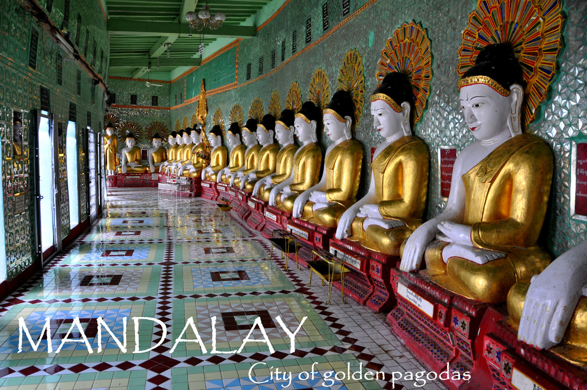
1 - Title page for Mandalay on a scene at the Umin Thonze Pagoda
(Download)
2 - Temples and pagodas on Sagaing Hill, seen from a view point along the Irrawaddy River close to the Yadanabon Bridge
(Download)
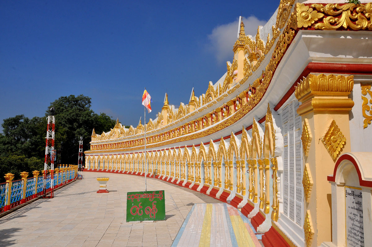
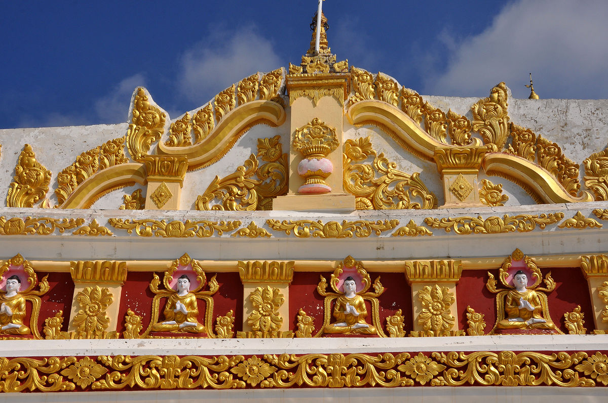
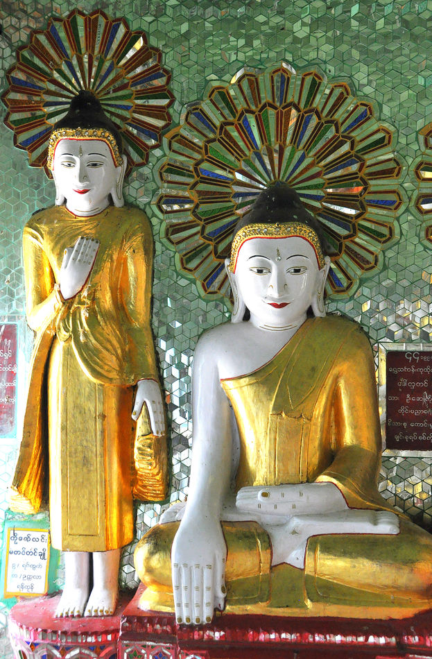
3 - Crescent-shaped terrace at Umin Thonze Pagoda (literally: 30 Caves), there are 45 Buddha statues behind the white wall and arches
(Download)
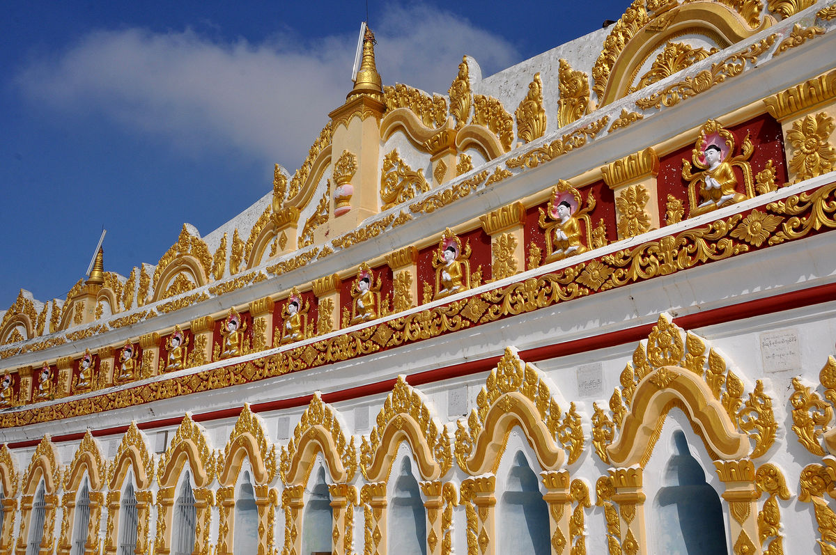
4 - Details of the wall at the crescent-shaped terrace at the Umin Thonze Pagoda
(Download)
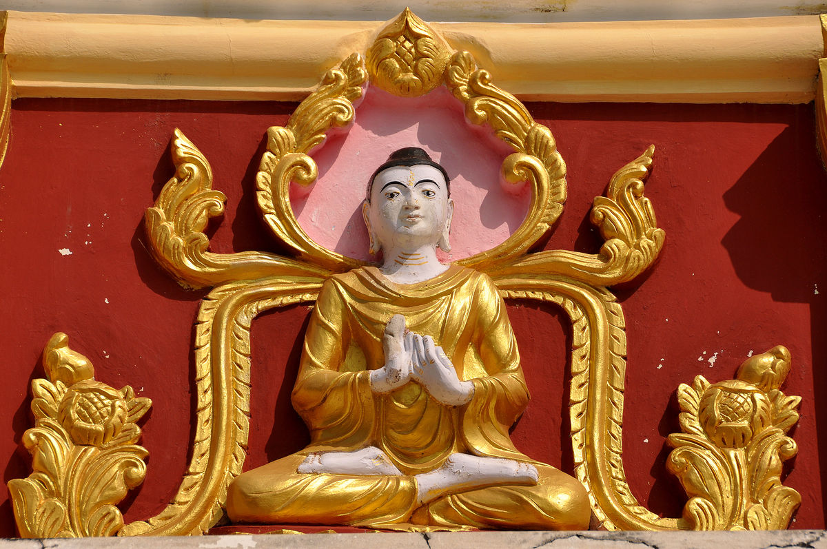
5 - Closing further in on a small array of these wall decorations
(Download)
6 - Real close-up detail of just one Buddha statue of the massive wall decorations
(Download)
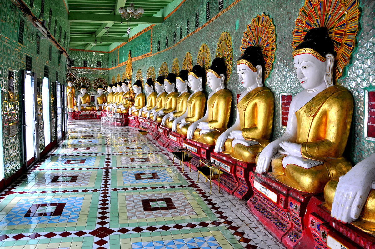
7 - Interior scene with a row of 45 Buddhas lined up inside the crescent-shaped colonnade at Umin Thonze Pagoda
(Download)
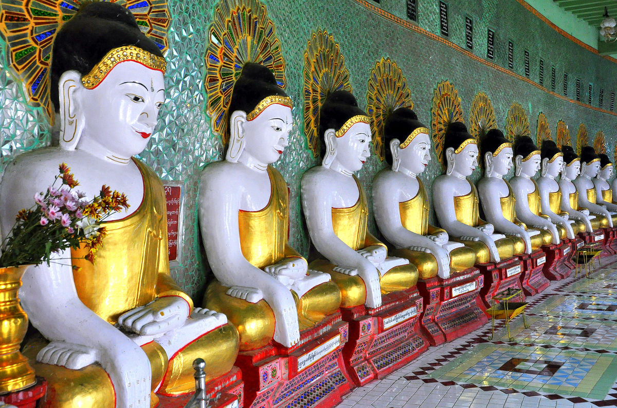
8 - View of the seemingly endless parade of Buddha statues from the opposite side
(Download)
9 - A standing and a sitting Buddha statue at the perimeter wall of the long row of Buddhas
(Download)
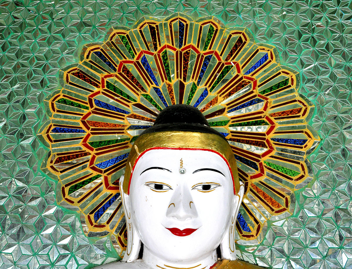
10 - Portrait detail of one of the Buddhas
(Download)
Apr 3, 2022 10:38:53 #
For your reference:
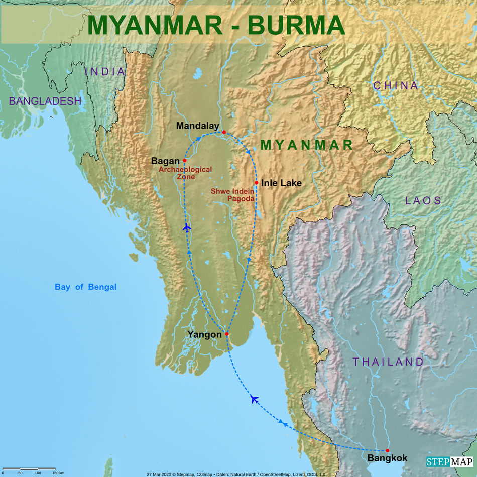
11 - Trip map of the Myanmar segment of our tour
(Download)
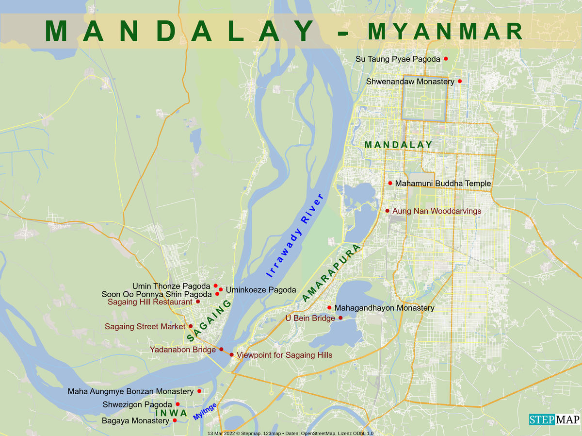
12 - Map of the sights within Mandalay
(Download)
Apr 3, 2022 11:05:07 #

Apr 3, 2022 11:08:48 #

Apr 3, 2022 11:10:06 #

Apr 3, 2022 11:19:01 #

Fascinating. I was interested in the green wall behind the Buddhas. Are those individual tiles?
Apr 3, 2022 11:19:10 #
Fascinating. I was interested in the green wall behind the Buddhas. Are those individual tiles?
Apr 3, 2022 12:10:35 #
Longshadow wrote:
Number two is great!
Number two is great!
Thanks Bill, I was lucky that we spotted an available corner and I got our driver to pull over in this spot, it was an impromptu location that yielded this impressive view of the hill.
Apr 3, 2022 12:13:49 #
UTMike wrote:
The color and detail are magnificent, Joe!
Thank you Mike, yes after the also attractive but rather uniform mostly red brick structures down in Bagan, these sites here mainly sparkle in white and/or gold.
Apr 3, 2022 12:14:40 #
angler wrote:
Great set Joe.
Thank you Jim, glad you like this introductory set for Mandalay.
Apr 3, 2022 12:21:15 #
NMGal wrote:
Fascinating. I was interested in the green wall behind the Buddhas. Are those individual tiles?
Thank you Barbara. Yes, these are definitely tiles. But I cannot figure out whether the tiles are green or glass. The roof is definitely green, as we can see in picture #7. The walls seem to be more green on the top than at the bottom, this would either be because they are glass and reflect at the top the color of the ceiling and at the bottom the light coming in from the side or it could also be that they are a highly reflective green tile that turns to almost clear where the lower outside light hits the surface.
Apr 3, 2022 12:45:07 #

weberwest wrote:
So here we are now in MANDALAY, the "CITY OF ... (show quote)
What a magnificent group of dazzlers 🏆🏆🏆🏆🏆
Apr 3, 2022 13:36:45 #
Wow, what a divergence from the last location. Fantastic perspectives in and around this amazing pagoda!!
The landscape shot is so colorful with the boats leading into the many golden spires! Looking forward to the rest of this incredible city.
Really great set Joe!!
Rob
The landscape shot is so colorful with the boats leading into the many golden spires! Looking forward to the rest of this incredible city.
Really great set Joe!!
Rob
Apr 3, 2022 16:31:55 #
joecichjr wrote:
What a magnificent group of dazzlers 🏆🏆🏆🏆🏆
Thanks Joe, glad you liked this group of dazzlers!
Apr 3, 2022 16:40:31 #
Umnak wrote:
Wow, what a divergence from the last location. Fantastic perspectives in and around this amazing pagoda!!
The landscape shot is so colorful with the boats leading into the many golden spires! Looking forward to the rest of this incredible city.
Really great set Joe!!
Rob
The landscape shot is so colorful with the boats leading into the many golden spires! Looking forward to the rest of this incredible city.
Really great set Joe!!
Rob
Thanks Rob. Yes, this second image was a lucky, unplanned shot. We actually just arrived from the airport and our driver plus guide were going to show us the Sagaing Hills first. For that we needed to cross one of the few bridges over the Irrawaddy and just before getting to the bridge, I noticed this view with the boats in front and the hill with the pagodas strewn all over it. I asked whether we could make a stop and the driver quickly found a spot to turn in just before we reached the bridge and the image resulted from that quick decision. It is not the best shot technically, and it was a bit hazy, but it is one of my favorites because it so well shows the hill, and the boats were an additional bonus. Yes, this place is quite different, with the hills so much closer we get a better feel for the landscape then in basically very flat Bagan. That provides more background for the temples and also more viewpoints from where to look over the landscape. So quite a different feeling and also we will see quite different scenes both of structures like monasteries and pagodas, but also more of the life of the monks at one of the monasteries and some interesting workshops.
If you want to reply, then register here. Registration is free and your account is created instantly, so you can post right away.