Posts for: h0grider
Oct 12, 2021 11:45:40 #
Just received this in my inbox from Outdoor Photographer. It's a short article on the Bear Rocks location in West Virginia at which my photograph was taken and also has a nice picture of the fall foliage on the blueberry bushes too. I can attest to the truth of the statement about FR75, "...a gravel road with some potholes and rocks that must be avoided." The road up from WV route 28/7 (Jordan Run Road) on the eastern side of the front is in much better shape than coming across the Sods! Here's the link:
https://www.outdoorphotographer.com/on-location/favorite-places/bear-rocks-preserve/
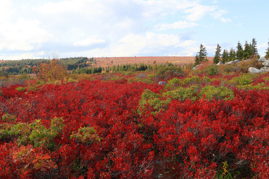
I've also attached my "long shot" view from Bear Rocks, taken the same day as the original post's image (basically all I had to do was turn around and shoot!).
https://www.outdoorphotographer.com/on-location/favorite-places/bear-rocks-preserve/
I've also attached my "long shot" view from Bear Rocks, taken the same day as the original post's image (basically all I had to do was turn around and shoot!).
Oct 9, 2021 17:17:58 #
Guyserman wrote:
A beautiful area and very nice shot. What were you bracketing? Focus? Exposure?
Exposure (manual at f/9 and ISO 100), starting at -2/3 for a baseline, then +/- 1.
Oct 7, 2021 21:09:56 #
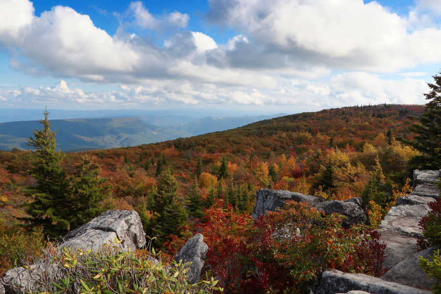
Taken early this week (10/5/2021) just off FR75 at the Bear Rocks parking area on the edge of the Dolly Sods Wilderness area. The red as far as the eye can see is foliage change from the blueberry bushes in the area. Image created from 3 bracketed exposures and merged in PSE 2021. The far ridge line is about a mile away (I think). The region is also known for its "flagpole" spruce seen in the image at the upper right, created by the high winds at the roughly 4,000 ft. elevation. This is about 20 miles "as the crow flies" from my earlier Lindy Point posting.
Enjoy this beautiful fall image.
Sorry the saved file is not a larger size, but I'm limited in the amount of data I have available over my cellular connection.
Enjoy this beautiful fall image.
Sorry the saved file is not a larger size, but I'm limited in the amount of data I have available over my cellular connection.
Sep 24, 2021 13:05:07 #
Longshadow wrote:
Nice!
Thanks for the compliment.
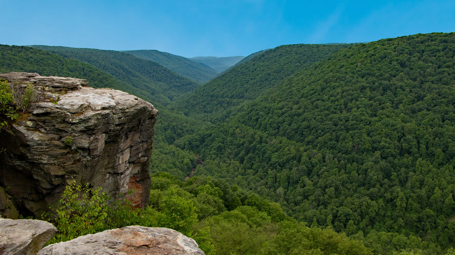
It's probably about 4 or 5 miles to the distant mountain in the middle of the picture. I'm not sure what the distance is to the mountain top just visible above that (left of center in the V) seen in the original, which is more than likely just south of Parsons, WV.
Sep 24, 2021 12:54:23 #
sb wrote:
Great viewpoint! Nicely composed.
Thanks. It could have been a bit sharper if I had used my tripod, but it was back in the car (of course)!
Sep 24, 2021 11:25:39 #
Scenic view taken in June at Blackwater Falls State Park, Davis, WV. In another 2 weeks or so these slopes should be a riot of color with the fall leaf changes. If you look closely, you can see a bit of the Blackwater River at the bottom of the canyon (to the right and bottom of the large stone outcropping).
The stored "original" is not the full size file, as I'm on a cellular connection for my internet and have to watch my data usage.
Enjoy and think of fall!
The stored "original" is not the full size file, as I'm on a cellular connection for my internet and have to watch my data usage.
Enjoy and think of fall!
Aug 17, 2021 18:13:23 #
john maloney wrote:
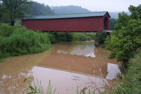
Garrett Co., Maryland morning.
Better be sure not to label your "wall hanger" as Garrett County, as this shot is from I-68 west of the big cut in Allegany County, MD. P.S. There are no authentic or red covered bridges in Garrett, but lots of barn quilts.
Other than missed location, nice shot! Now I know where to look for this nonauthentic bridge when I go by there returning home from "down east."
Jun 19, 2021 08:54:15 #
Is the item you are refering to the app "Windows Camera?" Thxs.
Apr 30, 2021 14:17:20 #
Linda S. wrote:
I need to take a video of myself...
If you have Canon's Camera Connect app installed on your smartphone (available at the Google Play Store for Android, and Apple's equivalent for Apple, devices), then you should be able to connect to your Canon camera with the app (assuming your camera has wifi or bluetooth capability, as you did not mention a Canon model, with the same being true for your smartphone). The camera must have its mode dial set for movie to record movies. Once connected via the app to your camera, your smartphone will have control over focusing modes, exposure adjustment, frame rates, whether to record sound or not, and a big button to start and stop the recording.
I can't help with any tutorials, but with the Canon Camera Connect app installed on your smartphone it is pretty straightforward on how to proceed to make the connection to the camera using the "Easy Connection Guide" button displayed prominently by the app's software once started (which you'll run each time you want to make a connection). I have Canon Camera Connect installed on 3 different types of devices (smartphone, laptop and tablet) and it works flawlessly on all three.
Apr 25, 2021 17:48:35 #
Probably a reference to the Casselman Inn, or perhaps Penn Alps?
Apr 25, 2021 09:42:55 #
AzPicLady wrote:
As long as I don't have to drive across the bridge! They terrify me. Thanks.
Be sure to check out the old mill in Babcock St Park if you visit the New River Gorge Bridge (NPS visitor center is here too at the bridge) in WV, very photogenic (you've probably even seen pictures of it).
BTW, if you are at the bridge it's not likely you'll be able to detour around it without a lengthy excursion or backtracking. The NPS site is off Rt 19 on the north side of the bridge, as well as the state park.
Apr 22, 2021 14:17:46 #
ronichas wrote:
I am planning a trip to Assateague and Chincoteague next week. Would love suggestions for photo ops.
Thanks in advance.
Thanks in advance.
Don't forget the lighthouse at Chincoteague (if you're into that sort of thing).
There's a public landing to the east of Spence in Maryland that could offer sunrise shots without the sand of the beach getting in your equipment! (The barrier island is about 5 miles out here.)
The "back" way from Chincoteague to Ocean City/Assateague via VA679 to MD12, then cutting from Girdletree to Spence is a way to keep off MD13/113 and enjoy the local sights.
Apr 22, 2021 13:04:21 #
ronichas wrote:
I am planning a trip to Assateague and Chincoteague next week. Would love suggestions for photo ops.
Thanks in advance.
Thanks in advance.
You might check out the launch schedule for NASA's Wallops Flight Center - you might get lucky and be able to observe/photograph one.
Be prepared for an entrance fee onto Chincoteague; this is collected by USFW, though may be too early in the season. A NPS pass should get you in for free.
Jan 14, 2021 17:21:38 #
photophile wrote:
I enjoy seeing reflections in nature and elsewhere and would like to see what you find, too!
As a "chaser" of covered bridges, one of the prime photo opportunities is to obtain a reflection shot. Of course, lots of things get in the way of this: terrain, wrong angles, poison ivy!, and lack of any water to produce a reflection (a surprising number of bridges, especially relocated to parks, cross over dry land). Here are 3 "reflections" from a few bridges I have photographed over the years covering West Virginia, Ohio and the Vermont-New Hampshire state line. (The first two were taken with a basic point-and-shoot, so uncertain how the downloads will look.)
The file name gives the county and the state the bridge is located, as well as the name of the bridge.
Enjoy!


Nov 14, 2020 09:32:46 #
bleirer wrote:
I inquired with Canon email. They just sent the instructions.
Don't leave us hanging in suspense. What was Canon's reply, if you don't mind sharing?