Oregon Hood River Fruit Loop Photo Ops?
Aug 12, 2018 11:59:10 #

Going from Government Camp to Portland via Hood River and WA Hwy. 14 and wondering which route might offer more photo ops of isolated barns with Mt. Hood or Mt. Adams in the background--Hwy. 281 or Hwy. 35? (Not interested in stopping for wine tasting, etc., just scenic views.)
For those who offered suggestions on routing from Portland to Astoria/Cannon Beach on a previous post, your feedback encouraged me to start the trip that direction and keep the original return route to include Oregon Gardens and Trillium Lake with a stay at Government Camp.
Just a few more weeks, then board the plane on Aug. 30th. Looking forward to being back in Oregon! Any help will be much appreciated.
Aug 13, 2018 07:22:05 #

Aug 13, 2018 08:24:41 #
mizzee
Loc: Boston,Ma
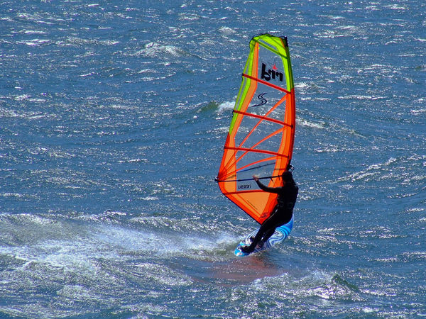
Hood River is one of the world’s wind surfing Mecca’s. We camped with my brother in-law at the Bingen(spelling?) Marina, but I doubt that is still possible. Whatever route goes along the river is the one you want, see map. Be sure to bring along a good action lens as the wind surfers there are pros doing fabulous tricks on their boards. Very exciting!
P. S. Do not be tempted to try to learn to wind surf there. I was a dropout from the Rhonda Smith School of Windsurphing. Long story!
P. S. Do not be tempted to try to learn to wind surf there. I was a dropout from the Rhonda Smith School of Windsurphing. Long story!
Aug 13, 2018 09:50:02 #
gvarner
Loc: Central Oregon Coast
Either one. 281 is the local route that takes you through Parkdale and the other communities, 35 is the main straight shot highway from Hood River to Mt. Hood. If you're in no hurry you could do 281. We took the train ride that parallels that roads diet was prett good for views.
Aug 13, 2018 13:46:27 #
traderjohn wrote:
Check out a map.
Yep, I checked out a map in order to narrow down my travel route around Mt. Hood to either Hwy. 281 or Hwy. 35. Not sure how a map will show me where the most scenic views are, though. I need some feedback from the photographers on this sight with a good eye for landscape compositions.
Aug 13, 2018 14:08:16 #
mizzee wrote:
Hood River is one of the worldâs wind surfing Meccaâs. We camped with my brother in-law at the Bingen(spelling?) Marina, but I doubt that is still possible. Whatever route goes along the river is the one you want, see map. Be sure to bring along a good action lens as the wind surfers there are pros doing fabulous tricks on their boards. Very exciting!
P. S. Do not be tempted to try to learn to wind surf there. I was a dropout from the Rhonda Smith School of Windsurphing. Long story!
P. S. Do not be tempted to try to learn to wind surf there. I was a dropout from the Rhonda Smith School of Windsurphing. Long story!
Mizzee--don't think I'll be trying any windsurfing at my age, but I can appreciate your having a long story about windsurfing school--you probably have a story similar to my younger days trying to learn water skiing. (LOL)
Is the windsurfing specifically around the town of Hood River on the Columbia River (which is where I have photographed them before) or are you speaking of the actual Hood River that runs south to north between the two highways I mentioned? I've never been south of the gorge and am not familiar with the river named Hood. But photographing the surfers is a lot of fun. This shot is from a dozen years ago (old P&S camera) taken on the Columbia. I would welcome a do-over with my current camera eqiupment.
Aug 13, 2018 14:13:13 #
gvarner wrote:
Either one. 281 is the local route that takes you through Parkdale and the other communities, 35 is the main straight shot highway from Hood River to Mt. Hood. If you're in no hurry you could do 281. We took the train ride that parallels that roads diet was prett good for views.
We won't be any particular hurry so will gladly take Hwy. 281 if it affords better rural scenery for landscapes. The rows of grapes at the wineries should make some nice compositions with the mountains in the background. Love 'character' barns, too. Think we'll see more of those on #281?
Aug 13, 2018 15:20:18 #
Sannye
Loc: Oregon
It’s so smoky, it may not matter. Check weather reports and if the wind is coming from the west, it may clear.
We have been slammed with wildfires this year.
We have been slammed with wildfires this year.
Aug 13, 2018 15:59:11 #
Was there just 12 days ago. Take direct road from Hood River to Parkdale. On way, look for signs to Lavender Valley. 1/4 mile off of highway. Beautiful lavender gardens. They will allow you to go into the gardens to photograph it. Lots of orchards along the road. Beautiful view of Mt. Hood across Lost Lake at state park. 10-15 miles off of highway, but scene was worth the trip. All of the real vineyards are east of Mt. Hood. Made the mistake of hoping to visit them after camping at Lost Lake and heading towards Portland. Missed them all.
Aug 13, 2018 20:08:10 #
Sannye wrote:
It’s so smoky, it may not matter. Check weather reports and if the wind is coming from the west, it may clear.
We have been slammed with wildfires this year.
We have been slammed with wildfires this year.
I thought most of the fires were in the south, and didn't realize there was one in the Gorge until your post prompted me to check the fire map. Not good--and so sad to see so much beautiful earth being scarred for years to come and people being displaced from their homes. I may have to reconsider just staying on the coast. Thanks for the heads up, Sannye.
Aug 13, 2018 20:50:46 #
notoldyet wrote:
Was there just 12 days ago. Take direct road from... (show quote)
This helps! I was wondering which lavender farm to visit and whether any blooms lasted into the first part of September...from what I could read about it, there might still be some color that late. Didn't have Lost Lake on my radar (only Trillium) but it would be a logical detour while going through the valley. Thanks for the tips, notoldyet!
Aug 13, 2018 23:16:10 #

Aug 14, 2018 02:22:48 #

dmeyer wrote:
This helps! I was wondering which lavender farm to visit and whether any blooms lasted into the first part of September...from what I could read about it, there might still be some color that late. Didn't have Lost Lake on my radar (only Trillium) but it would be a logical detour while going through the valley. Thanks for the tips, notoldyet!
Lost lake I wouldn’t go out of my way for. Trillium is so superior.
Aug 14, 2018 07:49:35 #
tdekany wrote:
Lost lake I wouldn’t go out of my way for. Trillium is so superior.
Our plan is to arrive at Government Camp in time to explore Trillium in the late afternoon (maybe some sunset light) and then return before sunrise the next morning.
Arrival to Lost Lake would be on up in the day and lighting might be flat by then, plus the water would probably be choppier than in early morning. So, your input is much appreciated. Notoldyet had camped at Lost Lake and had the chance to see it under optimal conditions, I would think. As we all know, in photography it's all about the timing.
Aug 14, 2018 07:56:58 #
woodweasel wrote:
great subject, goodluck
Come mid-September, hopefully, you'll see the outcome of this discussion when I post my travel images. This area will be new ground for me not covered in several previous visits to Oregon. I need good luck...and good weather. Just praying that the extreme heat will abate and allow firefighters a respite from the endless battles.
If you want to reply, then register here. Registration is free and your account is created instantly, so you can post right away.