The Coming of Spring
Mar 7, 2018 08:44:59 #

treadwl wrote:
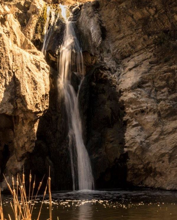
A different view of one of my favorite waterfalls in North Carolina.
Taken at F3.2 and 1/4 second from a tripod.
Please use the download. Thanks
Taken at F3.2 and 1/4 second from a tripod.
Please use the download. Thanks
Lovely!
Mar 7, 2018 08:45:46 #
Mar 7, 2018 09:09:42 #
tomad
Loc: North Carolina
treadwl wrote:
Thanks for looking. This is Soco Falls just out side of Cherokee on the south side of Smoky Mountain NP.
Thanks for looking and for the kind comment.
Thanks for looking and for the kind comment.
On a recent trip in that area I tried to find Soco Falls but missed it somehow. I was using Google Maps which knew where it was but the satellite coverage up there was so spotty that Google kept telling me I was there when I wasn't or first that it was a quarter mile ahead, then didn't speak again until I was way past. I went back and forth and I'm sure I must have past it several times. There didn't seem to be any signs or any parking area around. Can you tell me how to find it?
Mar 7, 2018 10:01:21 #
tomad wrote:
On a recent trip in that area I tried to find Soco Falls but missed it somehow. I was using Google Maps which knew where it was but the satellite coverage up there was so spotty that Google kept telling me I was there when I wasn't or first that it was a quarter mile ahead, then didn't speak again until I was way past. I went back and forth and I'm sure I must have past it several times. There didn't seem to be any signs or any parking area around. Can you tell me how to find it?
The falls is really difficult to find due to the fact that it is on the Cherokee Reservation and they to do not maintain it. The best way to see the very tiny sign is to approach from Cherokee heading toward Maggie Valley. I do not know the mileage from Cherokee as I've done it several times and just "know". I still have trouble finding it. Here is my best advice. While driving on HWY 19 toward Maggie Valley the road will make several big bends to the left. On one of these ends, on your right hand side there is a wide area on the right as you make the end. There is a steel guard rail and a garbage can at the turn. About 4-5 cars can park along the road at this wide spot. There is also a small green street sign that says Soco Falls. Sorry I can't do better than that. The falls is best seen in the late afternoon.
Mar 7, 2018 10:08:06 #
tomad
Loc: North Carolina
treadwl wrote:
The falls is really difficult to find due to the f... (show quote)
Thanks, I drive up there a couple of times a year. I'll give it another shot on my next trip.
Mar 7, 2018 10:09:24 #
Mar 7, 2018 12:31:38 #

treadwl wrote:
A different view of one of my favorite waterfalls in North Carolina.
Taken at F3.2 and 1/4 second from a tripod.
Please use the download. Thanks
Taken at F3.2 and 1/4 second from a tripod.
Please use the download. Thanks
Cool shot Larry😎

Mar 7, 2018 13:53:20 #
kerry12 wrote:
Really like the composition. Very pleasing to look at.
Thanks so much for looking. I do appreciate it.
Mar 7, 2018 13:54:11 #
Carolina Wings wrote:
Cool shot Larry😎
Thanks Carolina Wings. There are a great many composition possibilities at this falls, if you can get to it.
Mar 7, 2018 14:13:49 #

This is very beautiful Larry, love the composition, colour and light and the blurred water make for a stunning capture. 
Mar 7, 2018 14:14:49 #
rdrechsler
Loc: Channel Islands Harbor, CA
I love that shot. The blurring of the waterfall is great. You nailed it. I just took my first long exposure shot of a waterfall for a camera club assignment. I like the effect a lot. You are very right about the shadows.
Mar 7, 2018 16:39:53 #
treadwl wrote:
A different view of one of my favorite waterfalls in North Carolina.
Taken at F3.2 and 1/4 second from a tripod.
Please use the download. Thanks
Taken at F3.2 and 1/4 second from a tripod.
Please use the download. Thanks
very nice shot...i like the blur of the waterfall.
Mar 7, 2018 17:54:14 #
rdrechsler wrote:
I love that shot. The blurring of the waterfall is great. You nailed it. I just took my first long exposure shot of a waterfall for a camera club assignment. I like the effect a lot. You are very right about the shadows.
You have a nice shot for your first attempt at a long exposure. If i may offer a thought. The best days to shoot waterfalls are overcast and rainy days because there is no glare and bright spots on the water. And always use a polarizing filter!
Check the link below for an example.
https://reminisces.smugmug.com/Waterfalls-on-the-Blue-Ridge-P/Soco-Falls/i-dkksBQP/A
Thanks for looking and and commenting on my photo.
Mar 7, 2018 17:55:35 #
Sylvias wrote:
This is very beautiful Larry, love the composition, colour and light and the blurred water make for a stunning capture.
Thanks very much Sylvias. Think I'll try to blur the water a bit more next time.
Thanks for the compliment.
Mar 7, 2018 17:56:26 #
merrytexan wrote:
very nice shot...i like the blur of the waterfall.
This was something I was hoping to capture on the trip. I got lucky.
Thanks for commenting.
If you want to reply, then register here. Registration is free and your account is created instantly, so you can post right away.