Mt. Hood Oregon and the Cascade Lakes/Mt. Bachelor
Jun 24, 2017 20:11:06 #

We are making our annual trek to Sisters Oregon soon and are planning day trips to Mt. Hood and the Cascade Lakes Scenic Byway (on different days). Any advice on things we should see, including photo opportunities? Any other words of wisdom?
Thanks!
Thanks!
Jun 25, 2017 06:43:58 #
billnikon
Loc: Pennsylvania/Ohio/Florida/Maui/Oregon/Vermont
DJphoto wrote:
We are making our annual trek to Sisters Oregon soon and are planning day trips to Mt. Hood and the Cascade Lakes Scenic Byway (on different days). Any advice on things we should see, including photo opportunities? Any other words of wisdom?
Thanks!
Thanks!
tripadvisor.com
Jun 25, 2017 07:44:38 #

Take a drive out to Crater Lake,
When Mount Mazama erupted a little less than 7,000 years ago, its center imploded to form a caldera that gradually filled up with water, creating Crater Lake. With depths of 1,932 feet, it is the deepest lake in the United States (the seventh-deepest in the world) and is known for its stunning, sapphire blue color
When Mount Mazama erupted a little less than 7,000 years ago, its center imploded to form a caldera that gradually filled up with water, creating Crater Lake. With depths of 1,932 feet, it is the deepest lake in the United States (the seventh-deepest in the world) and is known for its stunning, sapphire blue color
Jun 25, 2017 09:49:31 #
Hwy 138 which goes from Roseburg to just north of Crater Lake and then down to Hwy 97 is known as the Hwy of Waterfalls. It is a gorgeous drive - some campgrounds along the way. http://www.southernoregon.org/article?articleName=highway-waterfalls" rel="nofollow" target="_blank">http://www.southernoregon.org/article?articleName=highway-waterfallshttp://www.southernoregon.org/article?articleName=highway-waterfalls If that link doesn't work just google Oregon Hwy 138 Waterfalls.
Jun 25, 2017 10:24:51 #
ptk
Loc: Oregon, USA
I second Highway 138 (I grew up in Roseburg). Check the roadside viewpoints, too; there are some spectacular rock formations visible from some of them.
If going down to Roseburg (to 138), take the MacKenzie Pass highway (if open, I forget the number, Sisters locals can tell you how to get to it). Large lava fields, with narrow road cuts (through the lava rock), scenic views of the Three Sisters mountains. It can also be done out and back in about a half day from Sisters.
138 also leads to the north entrance to Crater Lake NP, either via US97 to the east or I-5 to Roseburg to 138 in the west. But call the park first to see if the north entrance is even open. Most of the year it is closed due to deep snow. The south entrance is much, much farther from Sisters. If you do get to Crater Lake, there is a 33 mile road around the caldera, with many different views, worth taking (if open).
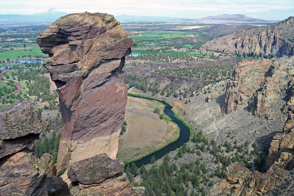
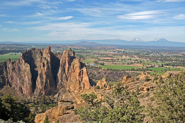
Very photogenic, not far east of there, is Smith Rock State Park, near Redmond. Hiking trails all over it, usually many rock climbers from all over the world.
If you like bridges, this one is not far from Sisters: <https://en.wikipedia.org/wiki/Crooked_River_Railroad_Bridge>. If you go to that one, you might as well catch this one, too: <https://en.wikipedia.org/wiki/Crooked_River_High_Bridge>. Just about anywhere on the Crooked River looks like the gorges shown in the bridge links.
If you like lava fields, but MacKenzie Pass is closed, just south of Bend is the Newberry National Volcanic Monument <https://en.wikipedia.org/wiki/Newberry_National_Volcanic_Monument>.
Have a great trip!
If going down to Roseburg (to 138), take the MacKenzie Pass highway (if open, I forget the number, Sisters locals can tell you how to get to it). Large lava fields, with narrow road cuts (through the lava rock), scenic views of the Three Sisters mountains. It can also be done out and back in about a half day from Sisters.
138 also leads to the north entrance to Crater Lake NP, either via US97 to the east or I-5 to Roseburg to 138 in the west. But call the park first to see if the north entrance is even open. Most of the year it is closed due to deep snow. The south entrance is much, much farther from Sisters. If you do get to Crater Lake, there is a 33 mile road around the caldera, with many different views, worth taking (if open).
Very photogenic, not far east of there, is Smith Rock State Park, near Redmond. Hiking trails all over it, usually many rock climbers from all over the world.
If you like bridges, this one is not far from Sisters: <https://en.wikipedia.org/wiki/Crooked_River_Railroad_Bridge>. If you go to that one, you might as well catch this one, too: <https://en.wikipedia.org/wiki/Crooked_River_High_Bridge>. Just about anywhere on the Crooked River looks like the gorges shown in the bridge links.
If you like lava fields, but MacKenzie Pass is closed, just south of Bend is the Newberry National Volcanic Monument <https://en.wikipedia.org/wiki/Newberry_National_Volcanic_Monument>.
Have a great trip!
Jun 25, 2017 10:28:05 #
ptk
Loc: Oregon, USA
ptk wrote:
Very photogenic, not far east of there, is Smith Rock State Park, near Redmond.
That should be "... not far east of Sisters ...". Sorry for the ambiguity in the original.
Jun 25, 2017 11:22:22 #
billnikon wrote:
tripadvisor.com
Thanks for the reminder. Tripadvisor is usually part of my trip planning process.
Jun 25, 2017 11:25:53 #
Mmart0418 wrote:
Take a drive out to Crater Lake,
When Mount Mazama erupted a little less than 7,000 years ago, its center imploded to form a caldera that gradually filled up with water, creating Crater Lake. With depths of 1,932 feet, it is the deepest lake in the United States (the seventh-deepest in the world) and is known for its stunning, sapphire blue color
When Mount Mazama erupted a little less than 7,000 years ago, its center imploded to form a caldera that gradually filled up with water, creating Crater Lake. With depths of 1,932 feet, it is the deepest lake in the United States (the seventh-deepest in the world) and is known for its stunning, sapphire blue color
This will be something like our 11th or 12th trip to Sisters in the last 8 years, and we've been to Crater Lake on three (?) of those trips. An absolutely beautiful place. Thanks for the reminder.
Jun 25, 2017 11:48:51 #
DrBobMaher wrote:
Hwy 138 which goes from Roseburg to just north of Crater Lake and then down to Hwy 97 is known as the Hwy of Waterfalls. It is a gorgeous drive - some campgrounds along the way. http://www.southernoregon.org/article?articleName=highway-waterfalls" rel="nofollow" target="_blank">http://www.southernoregon.org/article?articleName=highway-waterfallshttp://www.southernoregon.org/article?articleName=highway-waterfalls If that link doesn't work just google Oregon Hwy 138 Waterfalls.
We usually go up I-5 from the Bay Area to U.S. 97 because it's the most direct and is 500 miles and around 8-9 hours; it's a nice drive and we always do it in one day. However, we have taken some other routes, including part of OR 138 from 97 to 230 to 62 to Medford which is a very nice drive. However, we didn't stop for any waterfalls. We'll have to try your suggestion on this or one of our future trips. We have also driven 138/38 from I-5 west to the coast along the Umpqua River, and it's a beautiful drive.
Thanks for your input.
Jun 25, 2017 11:56:07 #
A lot on good suggestions on hwy 138 waterfalls - most are toward the I-5 side -
- If you are coming down 97 from sister there are 2 lakes on hwy 58 (comes before 138.
If staying in Mt. Hood area check out Timberline lodge on Mt Hood . They're several waterfalls in the Mt hood area.
If heading south on 97 take 138 and take the back way to crater lake.
Which way are you headed inAnd out of the Sisters area?(I live in Klamath Falls)
Jun 25, 2017 12:14:19 #
ptk wrote:
I second Highway 138 (I grew up in Roseburg). Che... (show quote)
I've driven the McKenzie Pass Highway a few times, and the views and lava fields from the Dee Wright Observatory are fantastic. I've driven over the Crooked River Bridge n U.S. 97 a few times, most recently a couple of years ago when we drove up to Madras to visit the Erickson Collection airplane museum (I love airplanes), but didn't stop to photograph the bridge. I was unaware of the railroad bridge though and will try to include it in our drive to Mt. Hood.
We have driven past the Newberry Monument many times, but have never stopped; sounds like a good bet when we drive the Cascade Lakes Scenic Byway.
We have driven past Smith Rock State Park, but have never visited it. We're not rock climbers and thus it didn't seem like something we would be interested in.
As I noted in an earlier response, we have visited Crater Lake a few times, though we have only driven the west rim since we do it on our way to Sisters. We've considered stopping for a day or two and really exploring the area.
Thanks for the info!
Jun 25, 2017 13:41:27 #
JBGLADSTONE
Loc: Oregon
Metolius River west of Sisters offers some small river views. Cabins along the river plus campgrounds. I love the river downstream from the Camp Sherman store at the fish hatchery. Green, blue, bubbling water from the bridge are photos which must be taken. Feeding the fish at the hatchery could create some family type pictures. You can even see large fish moving close to short of a small feeding pond.
I agree that century drive is a wonderful photo opportunity with large, small, tiny lakes within easy driving distances. Each one presents unique photo compositions. There are small or tiny lakes within easy walking near Duffy lakes. The Deschutes River parallels the Century Drive Highway. Fall River is a very cold river with clear views of the bottom. Also on Fall River is the fish hatchery with the river in the background for neat photos.
It would take days and days to take photos all the various views. Yes, even a lava bend past Davis Lake. Lodges at some of the lakes could present some cool pictures. ( a side note: I just saw a beautiful photo taken at night at Sparks Lake showing campgrounds and the milky way.
Could I go on and on, yup. If it were me in that area, I would be asking campers or people where to go and what they think of a good place to take photos.
Jun 25, 2017 13:48:28 #
Some of the best views of Mt. Hood are from Trinity Lake which is just a short drive from Hiway 26 near the summit. On a windless day you can get stunning reflections of the mountain.
Jun 25, 2017 13:50:30 #
JBGLADSTONE
Loc: Oregon
dbarber71 wrote:
Some of the best views of Mt. Hood are from Trinity Lake which is just a short drive from Hiway 26 near the summit. On a windless day you can get stunning reflections of the mountain.
I believe that lake is Trillium Lake.
Jun 25, 2017 14:00:17 #

I'll echo other's suggestions of visiting Smith Rocks SP if you're in the area. There are some extraordinary scenic views both from the overlook near the parking area, and certainly if you want to hike some/all of the loop trail. If you take the trail (drop into canyon and go right, cross bridge over the river then start uphill), it will take you up to Asterisk Pass at the top of Smith Rocks. You will be right next to Monkey Face, the iconic rock climbing feature, along with many outstanding views of the river and canyon, the Cascades, and the rock formations.
If you want to reply, then register here. Registration is free and your account is created instantly, so you can post right away.