Check out Close Up Photography section of our forum.
My first Youtube video
Feb 6, 2013 18:08:35 #

probably not what you might expect, but I find it interesting to watch, so you may also... a weather animation for January over North America:
http://www.youtube.com/watch?v=sCM1uLXmKkI
I've been playing around with controlling Google Earth and Photoshop with Applescript, with some fun results so far...
http://www.youtube.com/watch?v=sCM1uLXmKkI
I've been playing around with controlling Google Earth and Photoshop with Applescript, with some fun results so far...
Feb 6, 2013 22:53:09 #

Very cool. I loved it. Will be looking for more. I have taken small time lapse of weather but that was great! :thumbup: :)
Feb 6, 2013 23:04:31 #
Thanks! Just today I modified my screencapturing program to take shots over Europe and Australia also. The next batch of captures will be slightly higher resolution and the next video will be 720p (unlike the current funky "XGA" size on Youtube now).
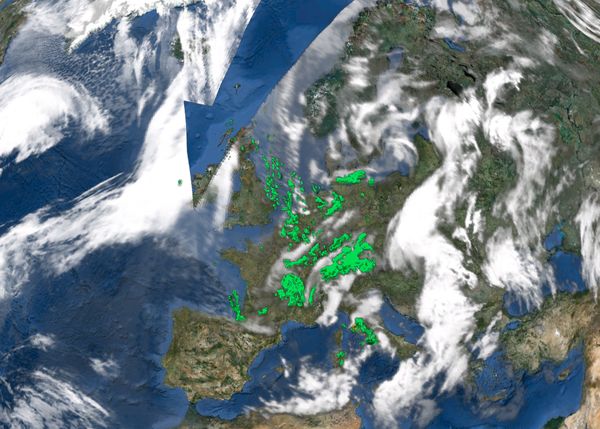
More to come, for sure... Unfortunately, I can't seem to get Google Earth to "fill in" a certain wedge of weather data above the UK, as seen here:
More to come, for sure... Unfortunately, I can't seem to get Google Earth to "fill in" a certain wedge of weather data above the UK, as seen here:
missing weather wedge over europe
Check out True Macro-Photography Forum section of our forum.
Feb 7, 2013 12:25:08 #
Feb 7, 2013 13:40:23 #
TrainNut wrote:
How often is each frame?
The images in Google Earth update at varying rates, with the radar updating more often than the clouds. I just grab the pics when the clouds update, which is roughly once every hour or so.
Feb 7, 2013 13:43:07 #
That is great, Thanks. I am going to start looking at the weather on Google Earth.
Feb 28, 2013 21:19:54 #
Wabbit
Loc: Arizona Desert
jazzplayer wrote:
Thanks! Just today I modified my screencapturing program to take shots over Europe and Australia also. The next batch of captures will be slightly higher resolution and the next video will be 720p (unlike the current funky "XGA" size on Youtube now).
More to come, for sure... Unfortunately, I can't seem to get Google Earth to "fill in" a certain wedge of weather data above the UK, as seen here:
More to come, for sure... Unfortunately, I can't seem to get Google Earth to "fill in" a certain wedge of weather data above the UK, as seen here:
Hey Doc ..... we didn't think that ya could cause you're not smart enough .....ha,ha,ha,ha,
If you want to reply, then register here. Registration is free and your account is created instantly, so you can post right away.
Check out Sports Photography section of our forum.