"GPS" navigation in 1971
Feb 25, 2024 09:09:04 #

Ernie1945 wrote:
I miss road maps, the ones that the gas stations had in a rack, free for the taking. I could look at a map and see how I "might like to go" instead of going how I am be in "told to go". I guess the fastest way to get to your destination is via the GPS, but then you may miss many sights that add to enjoyment of travel. If you're in a hurry, GPS's are a blessing but for enjoying the countryside, get out the map.
WAZE offers several routes and shows advantages and disadvantages of each.
Feb 25, 2024 09:11:37 #

ELNikkor wrote:
If you wanted to order a complete set for a delivery truck to navigate through London and suburbs, there'd be no room for the merchandise, just a whole library of cassette tapes guiding from every possible point to every other possible point.
That's the way I saw it. So if I wanted to go to my friend's house in the next town, I'd have one cassette but if I wanted to visit another friend in that town but the next street over, I'd need a different cassette even though 95% of the route would be the same for both? Nice try!
Feb 25, 2024 09:45:25 #
My first experience was with a rental car. At some point it quit working, so we called in. Told to goto trunk and press a button on a quite large metal box to reset it. It certainly did not take up the space, but it was pretty big as I remember bolted to floor at the back of the trunk.
Feb 25, 2024 10:02:00 #
And to think we used to rely on AAA Trip-Tiks to get us around the country. Now, I’m foolish enough to believe the GPS even when I disagree or think/know it’s wrong.
Feb 25, 2024 10:40:35 #

The first car I had in 1967 had a GPS that gave me driving instructions and watched my speed. It was my bride sitting next to me. 😁
Feb 25, 2024 10:56:42 #
Racmanaz
Loc: Sunny Tucson!
sippyjug104 wrote:
The first car I had in 1967 had a GPS that gave me driving instructions and watched my speed. It was my bride sitting next to me. 😁
Those types of GPS's you never ever question the validity of their directions.
Feb 25, 2024 11:28:32 #
My Prii (both of them) came with GPS built in. The GPS determines the latitude and longitude where you are. That's not really very useful until you actually place it on a map. The smartphone GPS does that nicely, but the built-in car units depended on a map on a disk located somewhere in the car. The problem is that the road system is not a constant. Roads are being modified and new roads are being built (and old roads are probably being abandoned). Consequently, after about 2 years I started to encounter GPS direction problems. For example, going north on I-91 and wanting to get onto I-84 used to be a right exit. The road was transmogrified so it's now a left exit. Also, exits on some interstates used to be numbered sequentially. Now there's a trend to number them by mileage, so the exit numbers have changed. While it is possible to buy a new disk that is 'up to date', the last time I looked the price was north of $250. And 'up to date' does not stay up to date.
The solution, of course, is to use the smartphone to supply the map. The smartphone can keep the map up to date. My Prius has not caught up with that solution (I don't have a new Prius and probably won't because my arthritis makes it hard for me to bend in the right directions needed to get in and out of a sedan. I will have to upgrade to an SUV or pickup). But I will certainly look for that capability in my next vehicle.
The first time I came across a GPS system was probably in the late '80s, where there was some research at MIT that used the GPS signal to keep track of ionospheric changes.
Feb 25, 2024 13:28:40 #
Funny! But very impractical. One has to sit down and plan out every turn and measure distance between each point from along the route and then record a cassette tape for each trip. But should one make a wrong turn, it can't recalculate, so the device becomes useless.
Long live GPS, which became operational as a military navigation system in 1978. President Reagan ordered the military to allow civilian use in the 1980s.
Long live GPS, which became operational as a military navigation system in 1978. President Reagan ordered the military to allow civilian use in the 1980s.
Feb 25, 2024 13:36:38 #

DirtFarmer wrote:
My Prii (both of them) came with GPS built in. The... (show quote)
I'm never willing to pay extra for a navigation system that is always out of date. We have the same useless Nav systems in our Priuses. (We bought the cars gently used, so the original owners were the suckers.)
Instead, we use iPhones with Maps, Waze, MapQuest, and Google Maps. They are great. When one of them lets us down, which is not very often, another one gets us back on track. The verbal turn-by-turn directions are getting so good, it makes us wonder how we ever got anywhere with paper maps!
Feb 25, 2024 13:51:31 #
1Oldnacl
Loc: Chesapeake Bay
f8lee wrote:
I recall seeing a TED Talk years ago where the pre... (show quote)
From; 1oldnacl
I believe you are incorrect in crediting Bell Labs with reverse engineering the concept, and developing the first Navigational satellites.
Drs William Guier, George Weiffenbach, and Frank T McClure of the Johns Hopkins Applied Physics Laboratory created the concept while tracking and observing the Doppler shift of Sputnik.With funding from the US Navy, the JHU/APL developed the "TRANSIT" satellite system for the Navy. It was developed after a few years of research and system development. It was declared operational in late 1962. It was successfully used by the Navy, long before GPS was developed and declared operational. The Transit satellites were launched in low earth polar orbits and weighed a mere 90 pounds. Based on principles of Doppler Navigation, they were much cheaper than GPS,since it required more development, huge satellites and higher orbits. GPS later produced a better, more accurate system for military and public use.
The TRANSIT is documented in "The Journal of the Institute of Navigation,Vol 15, No,, April 1962"
Feb 25, 2024 13:56:53 #
1Oldnacl wrote:
From; 1oldnacl br br I believe you are incorrect ... (show quote)
Thanks for setting the record straight with the true story. Transit was followed by NAVSTAR, which was renamed GPS when it was made available to civilians.
Feb 25, 2024 15:31:42 #
Tote1940
Loc: Dallas
At least you could get free maps at most gas stations!
Had a pile of them in car
In Germany bought a guide book with huge city maps detailed to every street, folded in an amazing way. Once unfolded, never more.
Had a pile of them in car
In Germany bought a guide book with huge city maps detailed to every street, folded in an amazing way. Once unfolded, never more.
Feb 25, 2024 16:47:30 #

ecblackiii wrote:
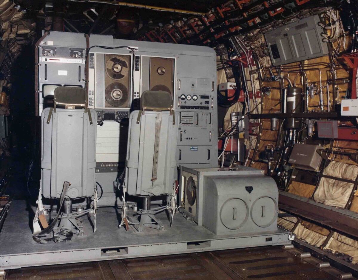
That's PART of the story. In the early spring of 1978 we only had 2 satellites on orbit - the other 2 signals came from ground based transmitters in the 'inverted range' at Yuma Proving Grounds - over which we flew our test-bed aircraft. Soon after when additional satellites were launched (8 satellites in each of 3 orbits) full navigational capabilities became available world-wide. When President Regan opened GPS to the public in 1983 after the Russian shoot-down of a Korean jet liner, we only released the CA-Code signal (clear-acquisition) with an accuracy of about 300 feet. The P (Precision code) signal remained encrypted until in 2000, President Clinton announced a commitment to grant civilians access to un-degraded GPS signals on par with those used by the military, and in 2007, under President Bush, the Department of Defense made that commitment permanent.GPS which became operational as a military navigation system in 1978. President Reagan ordered the military to allow civilian use in the 1980s.
GPS - 1978 - on a 10,000# pallet in the back of our C-141
(Download)
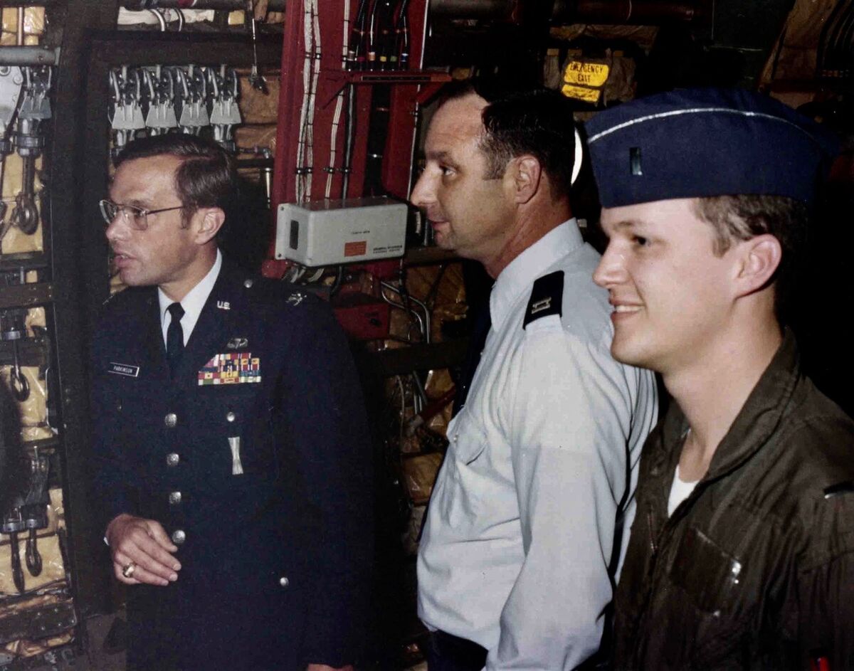
Col Brad Parkinson (the father of GPS), Capt Bud Bruenning, and Lt Merlin - way back then.
(Download)
Feb 25, 2024 16:49:49 #
Feb 25, 2024 21:02:17 #
ecblackiii wrote:
If you want the background - take a look at this:Thanks for the expansion of the story.
https://www.youtube.com/watch?v=Z5N4CqJLAhQ
Though the role I played in this program was small,
It was definitely the most important thing I participated in during my 46 year career.
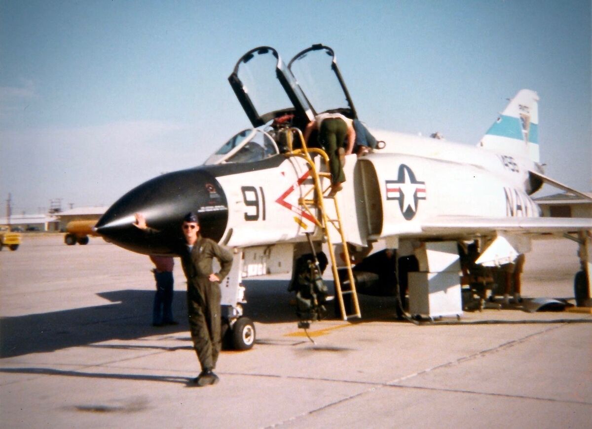
1Lt Merlin with his GPS enabled Jet. Please Ignore Magnavox Tech Gene Mooning you from above the back seat.
(Download)
If you want to reply, then register here. Registration is free and your account is created instantly, so you can post right away.