The Easier Part Of Hell's Revenge
Feb 1, 2023 18:09:04 #
Cany143
Loc: SE Utah
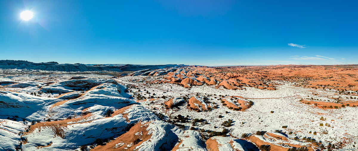
Hell’s Revenge is a challenging 4WD trail located in the Sand Flats Recreation Area immediately east of Moab (Ootha). In the accompanying image, a short portion of a flat, sandy, easy section of the trail can be seen, while elsewhere in view are some of the sandstone fins and domes and general geological features (over which the Revenge proceeds) that stretches out for eighty miles beyond. This view was made possible by getting aloft with my drone, and shooting in one of the panoramic modes it has available.
But neither the trail nor the lay of the land is the actual point of this post. O, hell, no! The point, instead, is the easier --though slightly agonizing-- section of another of Hell’s Revenges altogether, because, in fact, the Devil is entirely in the details. As mentioned above, this is a panorama that’s been stitched together from 21 separately shot images, fiendishly programmed into one of the pano modes in the flight controller and the firmware of the drone, and it’s really something to see in action. Not that you could, though, since in this sequence, to have seen it --since the drone was sufficiently distant from my piloting position that it couldn’t be seen-- you'd have either had to be viewing my controller, or you were, perhaps, some lost (or fallen? Yeah, more likely fallen….) angel, ravaging aimlessly around out there, seeking out the good and the evil, high above Hell’s Revenge.
Should I mention the size of the sensor? Should I state the focal length of the lens? Is the fixed f1.7 aperture a factor? Or is the camera's 12 megapixel sensor –that can, with the tap of a Devil’s Claw—be mysteriously transmogrified, transubstianted! --quadrupled in fact-- into a 48 mpx image, and captured in raw at that, a Hell in itself? I don’t know. And I don’t much care, either, since all I care about is the image, not the seventh circle of Dante’s Hell, that place and state of agony and moaning and toxic malevolence where Optical and Digital engineers (and whatever Digital Doubting Doofuses there be) do dwell.
About now you might be asking: a 48 mp image out of a 12 mp sensor? What fresh Hell is this??? And how many angels actually can twist on the nose of a drone, or would deign to dance a remotely operated dance? Questions like these –and the answers to them—are indeedy-do the true Demons of Hell’s Revenge, and that’s all way beyond me. All I give a rat’s azz about is the image. And your Hell’s Revenge is my place of ‘get ‘er done, Delbert.’
Aside, that is, from the demons, who rule the Intertubes, and force the torture of a gloriously compiled 500Mb, 16 bit, billboard-sized image down into a fiendishly web-able .jpg creature, writhing in reduction, and brought down to the depths of Hell.
Aaaaarrrrrrrggggggghhhhhhhhhhhhhhhh! That for me is Hell’s Revenge! And yup, the road is rough. Even if it is the easier part.
Feb 1, 2023 18:21:05 #

Feb 1, 2023 18:22:50 #

Feb 1, 2023 18:31:15 #
A H of an image! So stark, vivid, sharp. Love the poetic description too, Utah is quite the playground!
Feb 1, 2023 18:45:07 #

Cany143 wrote:
Hell’s Revenge is a challenging 4WD trail located ... (show quote)
Fantastic image!!!!
How do you get the Drone to come back to you ?
Feb 1, 2023 20:49:29 #

Feb 1, 2023 21:33:01 #

Feb 1, 2023 21:55:06 #
Cany143
Loc: SE Utah
Manglesphoto wrote:
Fantastic image!!!!
How do you get the Drone to come back to you ?
How do you get the Drone to come back to you ?
There are basically two (or possibly three) ways. The simplest of those is to initiate a "return to home" command on the controller, and because the drone has already set a home point via gps locking, the drone will automatically return to it's place of departure. Another way is to fly the drone back manually, using its camera to 'see' where it is and where you want it to end up. The way I prefer --but don't often utilize-- incorporates a mix of both the automatic and manual controls my thumbs exert of the joysticks in conjunction with the in-built hardware and software functions programmed into the drone, and sometimes includes profane language and/or laying a particularly tasty morsel of some rare and costly foodstuff out where I want the drone to land. Nothing is foolsafe, of course, and I have a nasty personal habit of eating the rare and costly bit of foodstuff beforehand.
Feb 1, 2023 21:57:27 #
Cany143
Loc: SE Utah
NMGal wrote:
After all that - a really nice photo.
Yabbut.........."it tells a story".
Ack.
Feb 2, 2023 05:46:34 #
Cany143 wrote:
There are basically two (or possibly three) ways. ... (show quote)
Thank you , I have often wondered about that
Feb 2, 2023 08:23:15 #

Cany143 wrote:
Hell’s Revenge is a challenging 4WD trail located ... (show quote)
Nice pano Cany, it sounds like a LOT of work, but I miss the presence of the scrubby tree (your calling card) in the foreground.
Jack Olson
Feb 2, 2023 08:38:54 #

Feb 2, 2023 10:27:39 #

Feb 2, 2023 13:02:51 #
slcarn
Loc: Draper, Utah USA
Cany143 wrote:
Hell’s Revenge is a challenging 4WD trail located ... (show quote)
Cany,
Your drone photographs are as amazing as your still shots, a well captured beautiful setting.
I am planning a 4x4 trip to Moab with a group of neighborhood friends in March. I hope to get some photos of the vehicles, especially mine, crawling over the rocks on these difficult trails. I will do some practicing with my drone and try to get some shots overhead.
Steve
Feb 2, 2023 13:31:59 #
If you want to reply, then register here. Registration is free and your account is created instantly, so you can post right away.