Check out Advice from the Pros section of our forum.
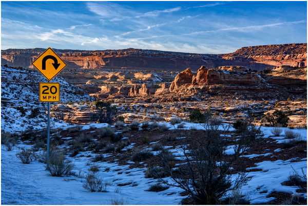
Red Rock, Blue Sky, Tight Curve
Jan 14, 2021 11:10:54 #
Jan 14, 2021 11:17:04 #


Jan 14, 2021 11:18:17 #

Cany143 wrote:
Partway down the switchbacks.
Must be fun when the road has a thin layer of ice!
Check out Printers and Color Printing Forum section of our forum.
Jan 14, 2021 11:26:59 #
Jan 14, 2021 11:27:52 #
Jan 14, 2021 12:28:53 #

You are torturing me, Jim! We are locked down up here and you post this.
Jan 15, 2021 07:43:44 #

Check out Astronomical Photography Forum section of our forum.
Jan 15, 2021 07:47:45 #
Jan 15, 2021 07:48:14 #

Jan 15, 2021 10:44:31 #
Jan 15, 2021 11:18:22 #

Great early morning image, love those old roads never know what's around the bend.
Check out People Photography section of our forum.
Jan 15, 2021 12:04:40 #

Jan 15, 2021 12:05:47 #

Gorgeous scene with glorious lighting🆒 Perfectly captured⭐
Jan 15, 2021 12:20:46 #
I once accidentally went down a set of switchbacks somewhere in the Carolinas...in a semi with a 53' trailer - kind of nerve-racking, but I survived.
Jan 15, 2021 13:16:28 #
Cany143
Loc: SE Utah
planepics wrote:
I once accidentally went down a set of switchbacks somewhere in the Carolinas...in a semi with a 53' trailer - kind of nerve-racking, but I survived.
A couple of years ago, some guy driving a semi (hauling a long-azz trailer, naturally) tried to descend the Shafer Switchbacks. Originally used as a cattle trail, then 'improved' slightly during Moab's mining days by blasting out sections of the canyon wall to make a 'road,' the Shafer Trail is now a minimally maintained 4WD road that drops some 1,400 feet over a mile and a half from the top of the Island Mesa down to what's called the White Rim Trail in the Island in the Sky District of Canyonlands Nat'l Park. Under ordinary conditions, the Switchbacks are not difficult if you're driving a high-clearance 4WD vehicle, but there are places where it isn't possible for one vehicle to pass another, and there are a number of extremely tight U-shaped turns. If there's been any snow --or worse, snow that's fallen, partially melted during the day, then frozen in the night, driving the Switchbacks is impossible. Similarly, if there's been a heavy rain, rocks large and small (and mud as mucky as you've ever seen) erode from the canyon walls, drop onto the road, and block it for days. To get back to the semi driver though, while I never heard an actual explanation for why he thought he could take his rig down that road, the best speculation I ever heard was that some road-finder GPS sort of thing had guided him. GPS or not, a person would have to be blind to fail to see the descent, the narrowness of the 'road,' and some of the tight switchbacks, but he tried it anyhow. Got maybe a fifth of the way down before dropping the driver's side front tire off an edge of the road. Just guessing, the drop from that edge was maybe 4-500 feet straight down --to the talus slope below, where it probably continued dropping another couple hundred feet. He didn't die, of course, but it wouldn't have surprised me if later I'd heard he'd had a stroke when somebody sent him his extrication/rescue/towing bill.
Additional note: The road --Utah Rte. 313-- along which I stopped to shoot this shot is paved. Its the only paved road that allows access to Dead Horse Point State Park and the Island section of Canyonlands N.P. Its got some major curves and bends and switchback sections, but its driven daily by all manner of vehicles, big rigs included. First time I ever drove it --in the mid '80's-- it wasn't paved, but was at least a well maintained gravel road.
If you want to reply, then register here. Registration is free and your account is created instantly, so you can post right away.