Fort Morgan, Alabama
Nov 15, 2020 09:13:30 #

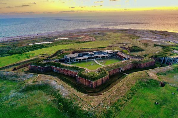
I am intrigued by old forts and military installations. This is an aerial photograph of Fort Morgan taken at sunset on Saturday, November 14, 2020. Fort Morgan sits on the eastern shore of the mouth of Mobile Bay at the Gulf of Mexico. It was actually active through World War II. I took the liberty of removing any items and structures not associated with the fort such as a communications tower, non native structures, paved roads, etc. I wanted to create a picture that I felt would be representative of the way the fort was before the area was modernized.
Photo taken with the DJI Mavic 2 Pro.
Photo taken with the DJI Mavic 2 Pro.
Nov 15, 2020 09:19:44 #


Nov 15, 2020 09:38:54 #
rayclay
Loc: Arab, AL., USA
The first fort was built several hundred feet out in the bay. I suppose global warming has been going on since the last iceage.
Nov 15, 2020 09:42:44 #
Nice rendering of the drone shot. Shows how much fun they can be and also how they can be used for documentary purposes. Please stay well and fly safely.
Nov 15, 2020 10:02:06 #

Nov 15, 2020 10:04:42 #

Great perspective! I've been to this fort, but didn't "understand" where it sits relative to the water until this perspective. Thanks.
Nov 15, 2020 11:35:23 #

Nov 15, 2020 13:15:52 #
Nov 15, 2020 14:40:14 #

The eastern forts as so different than the western (Indian barricades) Forts that when I saw Sumpter for the first time i wasn't sure it was a fort until I got inside and learned the history of it. such an engineering marvel. they are so awesome. Great shot. keep it up.
Nov 15, 2020 20:55:22 #

Terrific shot, John! The drone certainly puts things in a different perspective. I was out with friends last year and he was flying a drone. Every time the drone hit a tree branch or came close to a rock formation I could feel his wife suck in a big breath. She was relieved when he landed it. I’m going to wager you do not have that problem! 😊
Nov 16, 2020 06:47:10 #

Nov 16, 2020 07:21:13 #

Nov 16, 2020 07:31:35 #

Nov 16, 2020 08:15:24 #

Nov 16, 2020 09:46:15 #

That image is very cool. I’ve been there many times, but this image gives me a much better feel of what it was really like.
If you want to reply, then register here. Registration is free and your account is created instantly, so you can post right away.