Check out People Photography section of our forum.
Northern Ireland: East Antrim Landscapes
Jun 28, 2020 15:49:25 #

County Antrim (named after the town of Antrim, from Irish: Aontroim, meaning "lone ridge", is one of six counties that form Northern Ireland. Adjoined to the north-east shore of Lough Neagh, the county covers an area of 3,046 square kilometres (1,176 sq mi) and has a population of about 618,000. County Antrim has a population density of 203 people per square kilometre or 526 people per square mile. It is also one of the thirty-two traditional counties of Ireland, as well as part of the historic province of Ulster.
The Glens of Antrim offer isolated rugged landscapes, the Giant's Causeway is a unique landscape and a UNESCO World Heritage Site, Bushmills produces whiskey, and Portrush is a popular seaside resort and night-life area. The majority of Belfast, the capital city of Northern Ireland, is in County Antrim, with the remainder being in County Down.
According to the 2001 census, it is currently one of only two counties of Ireland in which a majority of the population are from a Protestant background. The other is County Down to the south.
At what date the county of Antrim was formed is not known, but it appears that a certain district bore this name before the reign of Edward II (early 14th century), and when the shiring of Ulster was undertaken by Sir John Perrot in the 16th century, Antrim and Down were already recognised divisions, in contradistinction to the remainder of the province. The earliest known inhabitants were Mesolithic hunter-gatherers of pre-Celtic origin, but the names of the townlands or subdivisions, supposed to have been made in the 13th century, are all of Celtic derivation.
In ancient times, Antrim was inhabited by a Celtic people called the Darini. In the early Middle Ages, southern County Antrim was part of the Kingdom of Ulidia, ruled by the Dál Fiatach clans Keenan and MacDonlevy/McDunlavey; the north was part of Dál Riada, which stretched into what is now western Scotland over the Irish Sea. Dál Riada was ruled by the O'Lynch clan, who were vassals of the Ulidians. Besides the Ulidians and Dál Riada, there were the Dál nAraide of lower County Antrim, and the Cruthin, who were pre-Gaelic Celts and probably related to the Picts of Britain. Between the 8th and 11th centuries Antrim was exposed to the inroads of the Vikings.
In the late 12th century Antrim became part of the Earldom of Ulster, conquered by Anglo-Norman invaders. A revival of Gaelic power followed the campaign of Edward Bruce in 1315, leaving Carrickfergus as the only significant English stronghold. In the late Middle Ages, Antrim was divided into three parts: northern Clandeboye, the Glynnes and the Route. The Cambro-Norman MacQuillans were powerful in the Route. A branch of the O'Neills of Tyrone migrated to Clandeboye in the 14th century, and ruled it for a time. Their family was called O'Neill Clannaboy. A Gallowglass sept, the MacDonnells, became the most powerful in the Glynnes in the 15th century.
During the Tudor era (16th century) numerous adventurers from Britain attempted to colonise the region; many Scots settled in Antrim around this time. In 1588 the Antrim coast was the scene of one of the 24 wrecks of the Spanish Armada in Ireland. The Spanish vessel La Girona was wrecked off Lacana Point, Giant's Causeway in 1588 with the loss of nearly 1,300 lives.
n 1689 during the Williamite War in Ireland, County Antrim was a centre of Protestant resistance against the rule of the Catholic James II. During the developing crisis James' garrison at Carrickfergus successfully repulsed an attempt by local Protestants to storm it. After the advance of the Irish Army under Richard Hamilton, all of County Antrim was brought under Jacobite control. Later in the year a major expedition from England under Marshal Schomberg landed in Belfast Lough and successfully laid siege to Carrickfergus. Having captured most of the largest towns of the area, they then marched southwards towards Dundalk.
https://en.wikipedia.org/wiki/County_Antrim
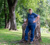
The number of photos I took of this beautiful area in a single day was astounding - even to me! The lush green landscapes were really beautiful. I hope you enjoy this set all of which were taken through the tour bus windows with a Nikon D7500 and Nikkor 18-300 lens at 1/640 sec f5.6 and auto iso.
Mark
The Glens of Antrim offer isolated rugged landscapes, the Giant's Causeway is a unique landscape and a UNESCO World Heritage Site, Bushmills produces whiskey, and Portrush is a popular seaside resort and night-life area. The majority of Belfast, the capital city of Northern Ireland, is in County Antrim, with the remainder being in County Down.
According to the 2001 census, it is currently one of only two counties of Ireland in which a majority of the population are from a Protestant background. The other is County Down to the south.
At what date the county of Antrim was formed is not known, but it appears that a certain district bore this name before the reign of Edward II (early 14th century), and when the shiring of Ulster was undertaken by Sir John Perrot in the 16th century, Antrim and Down were already recognised divisions, in contradistinction to the remainder of the province. The earliest known inhabitants were Mesolithic hunter-gatherers of pre-Celtic origin, but the names of the townlands or subdivisions, supposed to have been made in the 13th century, are all of Celtic derivation.
In ancient times, Antrim was inhabited by a Celtic people called the Darini. In the early Middle Ages, southern County Antrim was part of the Kingdom of Ulidia, ruled by the Dál Fiatach clans Keenan and MacDonlevy/McDunlavey; the north was part of Dál Riada, which stretched into what is now western Scotland over the Irish Sea. Dál Riada was ruled by the O'Lynch clan, who were vassals of the Ulidians. Besides the Ulidians and Dál Riada, there were the Dál nAraide of lower County Antrim, and the Cruthin, who were pre-Gaelic Celts and probably related to the Picts of Britain. Between the 8th and 11th centuries Antrim was exposed to the inroads of the Vikings.
In the late 12th century Antrim became part of the Earldom of Ulster, conquered by Anglo-Norman invaders. A revival of Gaelic power followed the campaign of Edward Bruce in 1315, leaving Carrickfergus as the only significant English stronghold. In the late Middle Ages, Antrim was divided into three parts: northern Clandeboye, the Glynnes and the Route. The Cambro-Norman MacQuillans were powerful in the Route. A branch of the O'Neills of Tyrone migrated to Clandeboye in the 14th century, and ruled it for a time. Their family was called O'Neill Clannaboy. A Gallowglass sept, the MacDonnells, became the most powerful in the Glynnes in the 15th century.
During the Tudor era (16th century) numerous adventurers from Britain attempted to colonise the region; many Scots settled in Antrim around this time. In 1588 the Antrim coast was the scene of one of the 24 wrecks of the Spanish Armada in Ireland. The Spanish vessel La Girona was wrecked off Lacana Point, Giant's Causeway in 1588 with the loss of nearly 1,300 lives.
n 1689 during the Williamite War in Ireland, County Antrim was a centre of Protestant resistance against the rule of the Catholic James II. During the developing crisis James' garrison at Carrickfergus successfully repulsed an attempt by local Protestants to storm it. After the advance of the Irish Army under Richard Hamilton, all of County Antrim was brought under Jacobite control. Later in the year a major expedition from England under Marshal Schomberg landed in Belfast Lough and successfully laid siege to Carrickfergus. Having captured most of the largest towns of the area, they then marched southwards towards Dundalk.
https://en.wikipedia.org/wiki/County_Antrim
The number of photos I took of this beautiful area in a single day was astounding - even to me! The lush green landscapes were really beautiful. I hope you enjoy this set all of which were taken through the tour bus windows with a Nikon D7500 and Nikkor 18-300 lens at 1/640 sec f5.6 and auto iso.
Mark

(Download)

(Download)

(Download)

(Download)

(Download)
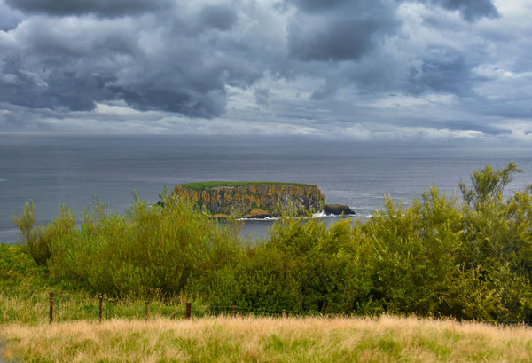
Sheep Island
(Download)

(Download)

(Download)

(Download)

(Download)
Jun 28, 2020 16:01:01 #

Jun 28, 2020 16:42:33 #

Check out Underwater Photography Forum section of our forum.
Jun 28, 2020 17:18:37 #
Jun 28, 2020 17:53:35 #
Jun 28, 2020 17:54:56 #
Jun 28, 2020 17:57:02 #
kpmac wrote:
Might be your best set yet, Mark. I'm still amazed at how you do it.
Thanks Ken. I really appreciate the compliments. Frankly, I can’t believe the results myself sometimes !
Check out Digital Artistry section of our forum.
Jun 28, 2020 22:55:06 #

It sure is green over there Mark! I like that rock/island off the coast with those cliffs and then green pasture on top - wonder if that grass ever gets used?
Jun 29, 2020 02:03:57 #
weberwest wrote:
It sure is green over there Mark! I like that rock/island off the coast with those cliffs and then green pasture on top - wonder if that grass ever gets used?
Thanks Joe. I guess that’s why they call it “the Emerald Isle”. That island is called sheep island so I guess there is a small herd that grazes there or did at one time. I did use the foliage enhancer on Luminar 4 to make the greens a little greener. I love that program!
Jun 29, 2020 05:52:31 #
It's not so much the greens that get me, but the density in the clouds. Wonderful set.
Jun 29, 2020 06:54:57 #
Check out Video for DSLR and Point and Shoot Cameras section of our forum.
Jun 29, 2020 07:07:40 #
I love your photo set and and also the very fascinating history. It may have been a little while ago but I love to know who did what to whom, and when.
Jun 29, 2020 07:11:12 #
srfmhg wrote:
County Antrim (named after the town of Antrim, fro... (show quote)
Been there many times. Giants Causway area is where my ancestors came from.
Jun 29, 2020 07:19:38 #
Jun 29, 2020 07:32:44 #

If you want to reply, then register here. Registration is free and your account is created instantly, so you can post right away.
Check out Black and White Photography section of our forum.