Route 66 near Winslow, Arizona
Sep 3, 2019 00:57:07 #

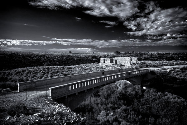
I just returned from Arizona where I came across these Native American ruins and a small portion of Route 66, now completely out of service (at least this portion). I thought of cropping some of the sky, but instead I was hoping to depict the expanse of the countryside. Obviously, the photo was converted to black & white with a touch of selenium toning and small amount of vignetting. There's some evidence that reconstruction of the ruins has taken place, but was given up decades ago from what I could see. Please feel free to comment and share your thoughts. Ken
Sep 3, 2019 02:33:48 #

I like the composition on this one, the B&W adds to the feeling of the lost road! Good job!
Phil
Phil
Sep 4, 2019 07:05:10 #

Sep 4, 2019 07:22:25 #


Sep 4, 2019 08:04:55 #

The download is very impressive. We’ve driven all of old Rte 66 and there are still some sections that have been preserved and are thriving - e.g., nearby Flagstaff. However, most sections are just reminders of how destructive the interstate system was for thousands of local businesses.
Sep 4, 2019 08:19:06 #

Sep 4, 2019 08:53:08 #

Nice, Ken, nice. This is what I had in mind when I commented on your other photo. These work well either way.
Sep 4, 2019 09:16:48 #

Sep 4, 2019 10:44:56 #
cdayton wrote:
The download is very impressive. We’ve driven all of old Rte 66 and there are still some sections that have been preserved and are thriving - e.g., nearby Flagstaff. However, most sections are just reminders of how destructive the interstate system was for thousands of local businesses.
The Interstates were built with the Cold War in mind. To be able to move troops at moment's notice.
Sep 4, 2019 11:35:04 #

Stephan G wrote:
Yep. The original routes were designed to totally bypass any major cities, too, as much as 50 miles apart from them, with spur roads going from the major roads to the cities. Of course, that plan would have eliminated most travel through the cities, and they complained very loudly about that, so the bypass idea was shelved. Of course, later on, the huge flow through the city centers became a problem, so bypass loops aroud them were built. Go Figure.The Interstates were built with the Cold War in mind. To be able to move troops at moment's notice.
Sep 4, 2019 11:52:18 #
Stephan G wrote:
The Interstates were built with the Cold War in mind. To be able to move troops at moment's notice.
The major differences, at least to my mind, is that US Routes were just that. "Routes". If you knew that Route 66 could get you from OK to CA or Route 1 went from Maine to Florida, you followed that number which took you over all kinds of local roads. They were just routes and not a hi way system. You also knew to carry road maps (from the major oil companies) because you could very easily miss a direction change. On the other hand the interstates are a system of hi-ways. Now you jump on I80 in Salt Lake City and stay with it to New York City. Good roads and good accommodations from start to finish.
Sep 4, 2019 11:53:48 #
Really nice shot and B&W is the only media for this one. I drove 66 back in 1963 in a 1962 MGA. No camera but it wouldn't have mattered my girl was in California and I was in kind of a hurry.
Sep 4, 2019 12:51:09 #

Very nice shot. Perhaps lowering the contrast just a bit could benefit this fine image.
Sep 4, 2019 13:33:55 #
camerapapi wrote:
Very nice shot. Perhaps lowering the contrast just a bit could benefit this fine image.
Ok. I'll work on that later this afternoon and see how it looks.
Sep 4, 2019 21:03:41 #

If you want to reply, then register here. Registration is free and your account is created instantly, so you can post right away.