Europe 2022 Trips - Photo Preview 24 - Switzerland: Nufenen Pass & Ticino scenes
Jan 30, 2024 09:55:59 #
An area always close to my heart in Switzerland is the canton Ticino, the only Swiss canton situated entirely on the southern side of the Alps, but reaching far into the Alps, and the only canton solely speaking Italian (which is also spoken in a small part of the canton Grison). When I was a teen, I frequently traveled to this canton for paternal visits, sometimes by train, more often by bicycle, which involved a long drive along Lake Lucerne, then a steep ascent up to the village of Göschenen, followed by a train ride (with the bicycle) through the Gotthard tunnel to Airolo, then a steep descent into Ticino. That was the most glorious part: "Flying" down the road at 50-60km per hour, feeling the breeze in your face and hair, and then a final ride across the hillsides to the town of Tenero near Locarno on the Lago Maggiore. The northern, partially uphill section to the entrance of the Gotthard tunnel was about 90 km long, the mainly downhill southern part about 80 km, thus totaling some 170 km (slightly over 100 miles) - not bad for a 14-year old at the start his travel experiences. The entire trip took about 10 hours, including the tunnel train transit. Once I actually did not take the tunnel, but instead crossed the Gotthard Pass, but that took quite a bit longer because of the substantial extra altitude, and I stayed in the hospice on top of the Gotthard Pass overnight. - Please forgive this old man the lengthy detour down memory lane.
In the fall of 2022 we decided to spend a few days in Ticino, sort of reliving the above-mentioned memories of my youth. But since we were driving in our car, this transit went much faster, so we decided to make a substantial detour: instead of taking the fast road tunnel through the Gotthard, we crossed two mountain passes: first the FURKA PASS (2429m/7969ft) from the town of Andermatt to Gletsch, then a short drive in the "Upper Goms" area to Ulrichen, followed by crossing the NUFENEN PASS (2478m/8130ft) to Airolo in Ticino, and finally driving on to the village of INTRAGNA strategically located at the entrance to the Centovalli valley, which leads to Domodossola in Italy, and also in close proximity to the entrance of the Valle Maggia, the largest valley in Ticino.
The photos in this set include a few glorious vistas from the drive over these two mountain passes (# 1-4) and then images from our drive up the MAGGIA VALLEY to the village of FUSIO high up at the top of this long valley (#5-7), and also a short detour to the BAVONA VALLEY with historic hamlets and Ticino's largest waterfall in FOROGLIO (#8-9). The final image shows the view from a mountain road down towards the town of OLIVONE/BLENIO on our return trip from the Ticino.
A few notes to specific pictures below where I do not have sufficient space in the captions for full description:
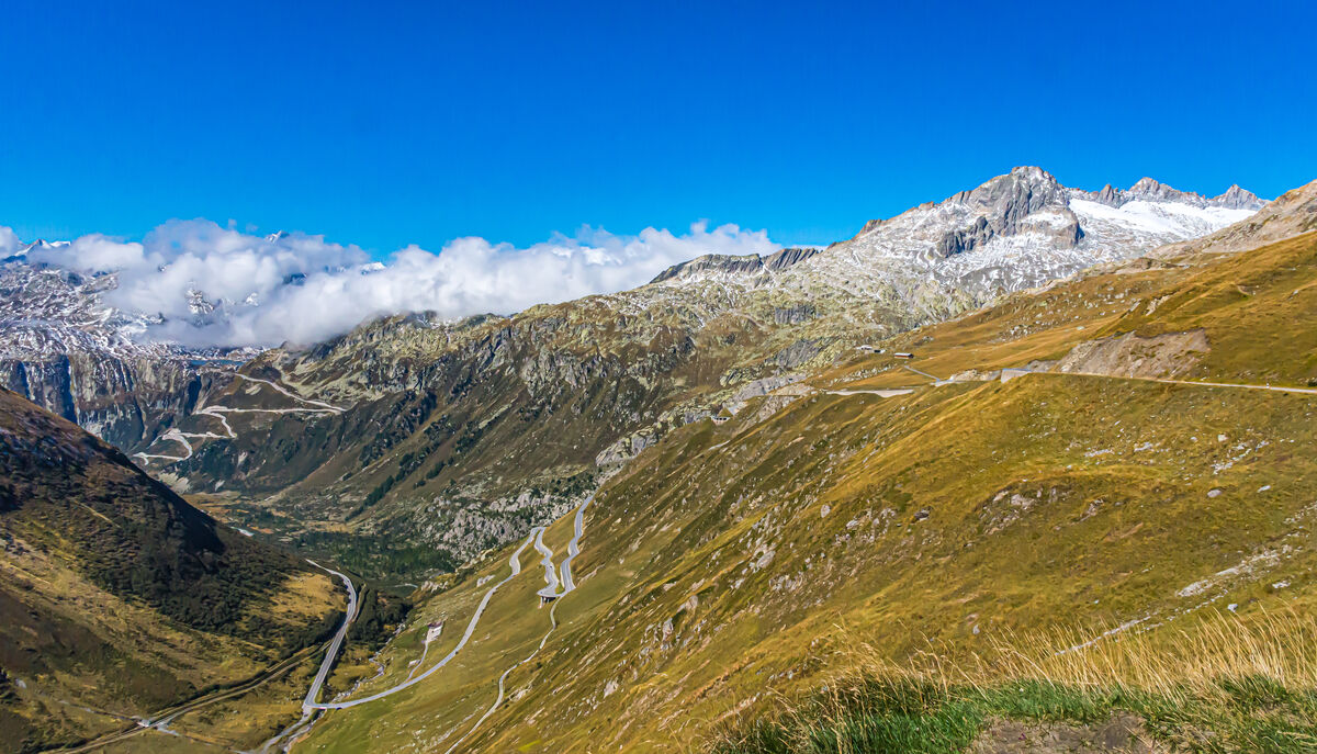
~ Image #1 - This view from the top of the Furka Pass depicts at right/center the Furkapass road descending towards the town of Gletsch, first in a long swoop, then in a number of switchbacks mainly behind the mountain with a few visible at the center of the picture. At upper left we see the serpentines of another pass road, the Grimselpass road ascending from Gletsch towards the Grimsel Pass, which we did not traverse this time. Very faintly visible at the top of the road is the pass at 2164m/7100ft with the blue water of Lake Grimsel.
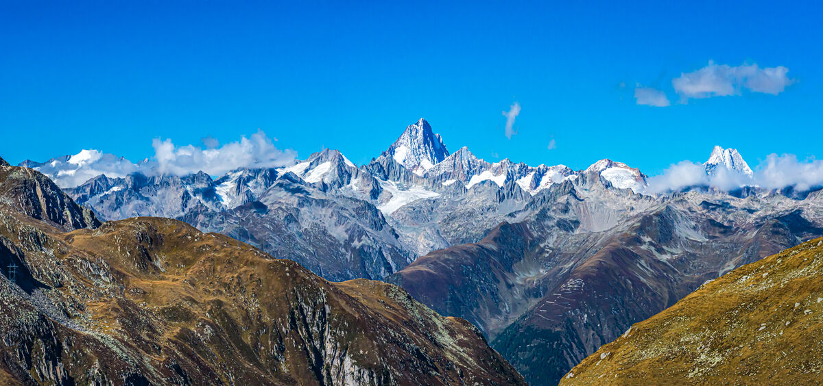
~ Image #2 - View from the top of the Nufenen Pass, the highest Swiss mountain pass at 2478m/8130ft to the glorious Finsteraarhorn peak (4274m/14,022ft) in the Valais/Bernese Alps, at right partially in the clouds another prominent peak: the Schreckhorn (4078m/13,379ft), which we saw in the previous set #23 (images 3 & 4) from the other, Bernese side.
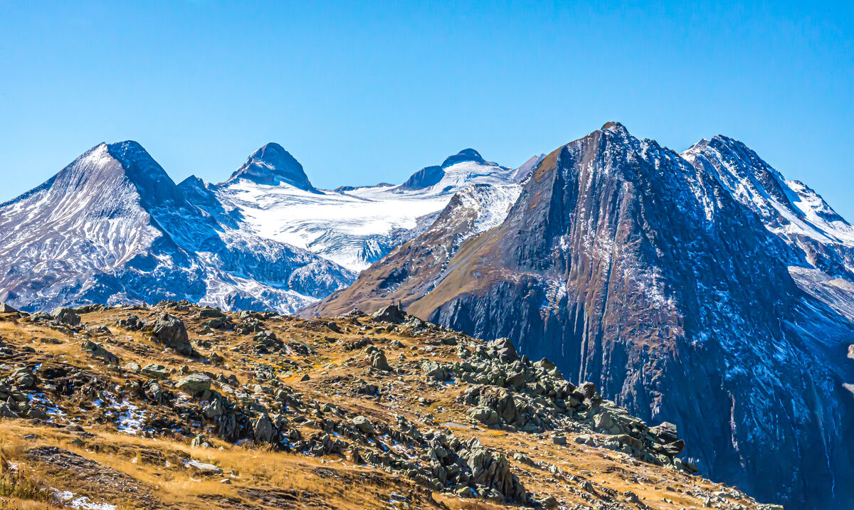
~ Image #3 - A spectacular set of peaks surrounding a glacier viewed from the top of the Nufenen Pass, from left to right: Bättelmatthorn/Punta dei Camosci (3044m/9987ft) - Corno Rosso (3289m/10,791ft) - Blinnenhorn/Corno Cieco (3374m/11,070ft) - Fülhorn (2863m/9393ft) - Ritzhörner (3107m/10,194ft)
~ Image #4 - On top of Nufenenpass: Nufenen Lake below the mountains (l to r): Galmihorn at far left (3506m/11,503ft) and adjacent Mittaghorn (3367m/11,047ft) - the white mountain in center: Pizzo Gallina (3061m/10,043ft) and at right the prominent Chilchhorn (2789m/9150ft).
A few links to further information, if so desired:
FURKA PASS - Info from Swiss Tourism - https://www.myswitzerland.com/en-us/experiences/furka-pass/
NUFENEN PASS - Info from Colcorsa - https://www.colcorsa.com/tour/nufenen-pass/
INTRAGNA - Info from Swiss Tourism - https://www.myswitzerland.com/en-us/destinations/intragna-capital-of-the-centovalli/
MAGGIA VALLEY - Info from Wikipedia - https://en.wikipedia.org/wiki/Valle_Maggia
FUSIO - info from Wikipedia - https://en.wikipedia.org/wiki/Fusio
BAVONA VALLEY & FOROGLIO WATERFALL - info from Swiss Tourism - https://www.myswitzerland.com/en-us/destinations/val-bavona/
Notes
TRIP INFO: Set # 1 provides a brief introduction to this series. Please use the link below if you would like to review this intro:
https://www.uglyhedgehog.com/t-797460-1.html
2022 TRIP INFO: Set # 19 provides more information on the two trips of the year to Europe
https://www.uglyhedgehog.com/t-798237-1.html
EARLIER POSTS of this series: Access my topic list at UHH, the new posts are listed in reverse chronological order:
https://www.uglyhedgehog.com/user-topic-list?usernum=45105
Thanks for visiting, I recommend viewing the downloads and look forward to your comments and questions.
.
In the fall of 2022 we decided to spend a few days in Ticino, sort of reliving the above-mentioned memories of my youth. But since we were driving in our car, this transit went much faster, so we decided to make a substantial detour: instead of taking the fast road tunnel through the Gotthard, we crossed two mountain passes: first the FURKA PASS (2429m/7969ft) from the town of Andermatt to Gletsch, then a short drive in the "Upper Goms" area to Ulrichen, followed by crossing the NUFENEN PASS (2478m/8130ft) to Airolo in Ticino, and finally driving on to the village of INTRAGNA strategically located at the entrance to the Centovalli valley, which leads to Domodossola in Italy, and also in close proximity to the entrance of the Valle Maggia, the largest valley in Ticino.
The photos in this set include a few glorious vistas from the drive over these two mountain passes (# 1-4) and then images from our drive up the MAGGIA VALLEY to the village of FUSIO high up at the top of this long valley (#5-7), and also a short detour to the BAVONA VALLEY with historic hamlets and Ticino's largest waterfall in FOROGLIO (#8-9). The final image shows the view from a mountain road down towards the town of OLIVONE/BLENIO on our return trip from the Ticino.
A few notes to specific pictures below where I do not have sufficient space in the captions for full description:
~ Image #1 - This view from the top of the Furka Pass depicts at right/center the Furkapass road descending towards the town of Gletsch, first in a long swoop, then in a number of switchbacks mainly behind the mountain with a few visible at the center of the picture. At upper left we see the serpentines of another pass road, the Grimselpass road ascending from Gletsch towards the Grimsel Pass, which we did not traverse this time. Very faintly visible at the top of the road is the pass at 2164m/7100ft with the blue water of Lake Grimsel.
~ Image #2 - View from the top of the Nufenen Pass, the highest Swiss mountain pass at 2478m/8130ft to the glorious Finsteraarhorn peak (4274m/14,022ft) in the Valais/Bernese Alps, at right partially in the clouds another prominent peak: the Schreckhorn (4078m/13,379ft), which we saw in the previous set #23 (images 3 & 4) from the other, Bernese side.
~ Image #3 - A spectacular set of peaks surrounding a glacier viewed from the top of the Nufenen Pass, from left to right: Bättelmatthorn/Punta dei Camosci (3044m/9987ft) - Corno Rosso (3289m/10,791ft) - Blinnenhorn/Corno Cieco (3374m/11,070ft) - Fülhorn (2863m/9393ft) - Ritzhörner (3107m/10,194ft)
~ Image #4 - On top of Nufenenpass: Nufenen Lake below the mountains (l to r): Galmihorn at far left (3506m/11,503ft) and adjacent Mittaghorn (3367m/11,047ft) - the white mountain in center: Pizzo Gallina (3061m/10,043ft) and at right the prominent Chilchhorn (2789m/9150ft).
A few links to further information, if so desired:
FURKA PASS - Info from Swiss Tourism - https://www.myswitzerland.com/en-us/experiences/furka-pass/
NUFENEN PASS - Info from Colcorsa - https://www.colcorsa.com/tour/nufenen-pass/
INTRAGNA - Info from Swiss Tourism - https://www.myswitzerland.com/en-us/destinations/intragna-capital-of-the-centovalli/
MAGGIA VALLEY - Info from Wikipedia - https://en.wikipedia.org/wiki/Valle_Maggia
FUSIO - info from Wikipedia - https://en.wikipedia.org/wiki/Fusio
BAVONA VALLEY & FOROGLIO WATERFALL - info from Swiss Tourism - https://www.myswitzerland.com/en-us/destinations/val-bavona/
Notes
TRIP INFO: Set # 1 provides a brief introduction to this series. Please use the link below if you would like to review this intro:
https://www.uglyhedgehog.com/t-797460-1.html
2022 TRIP INFO: Set # 19 provides more information on the two trips of the year to Europe
https://www.uglyhedgehog.com/t-798237-1.html
EARLIER POSTS of this series: Access my topic list at UHH, the new posts are listed in reverse chronological order:
https://www.uglyhedgehog.com/user-topic-list?usernum=45105
Thanks for visiting, I recommend viewing the downloads and look forward to your comments and questions.
.
1 - Valais/Oberwald-Gletsch - View from the top of the Furka Pass to the Furkapass road at right/center and at upper left the serpentines of the Grimselpass road (see further details in the descriptions above)
(Download)
2 - Valais/Ulrichen - View from the top of the Nufenen Pass to the Valais/Bernese Alps (see details above)
(Download)
3 - Valais/Ulrichen - Glacier and peaks view from the top of the Nufenen Pass (see details above)
(Download)
4 - Valais/Ulrichen - On top of Nufenenpass: Nufenen Lake below a series of mountain peaks (see details above)
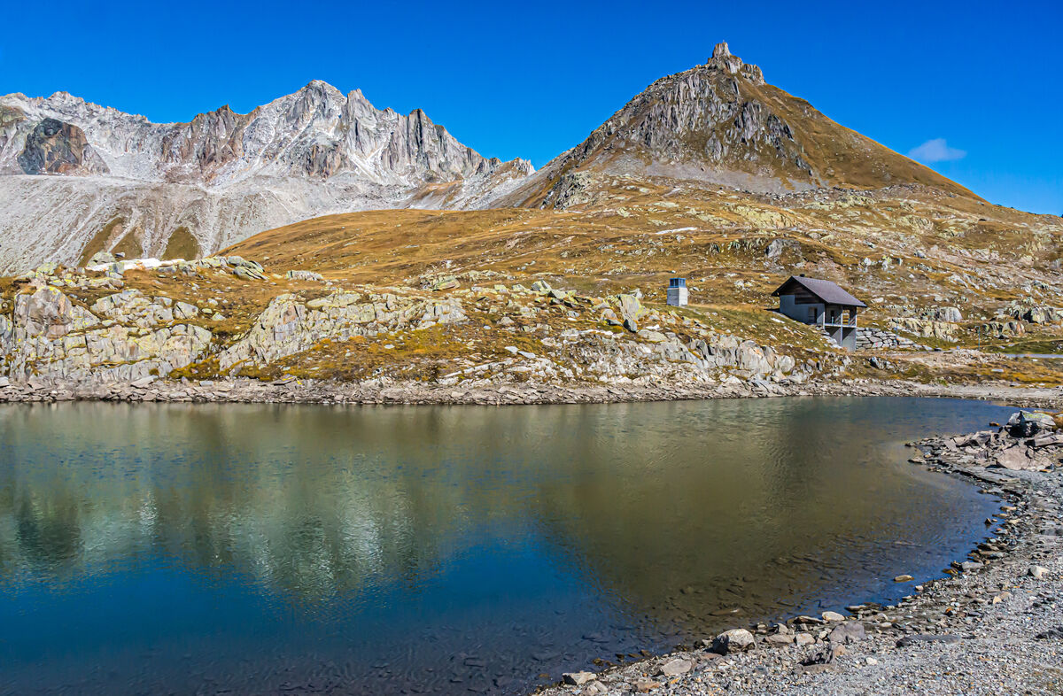
(Download)
5 - Ticino/Lavizzara - Pizzo Castello (2808m/9213ft) seen from Peccia - the bright lines display marble, at right in the distance Mount Poncione di Braga (2864m/9396ft)
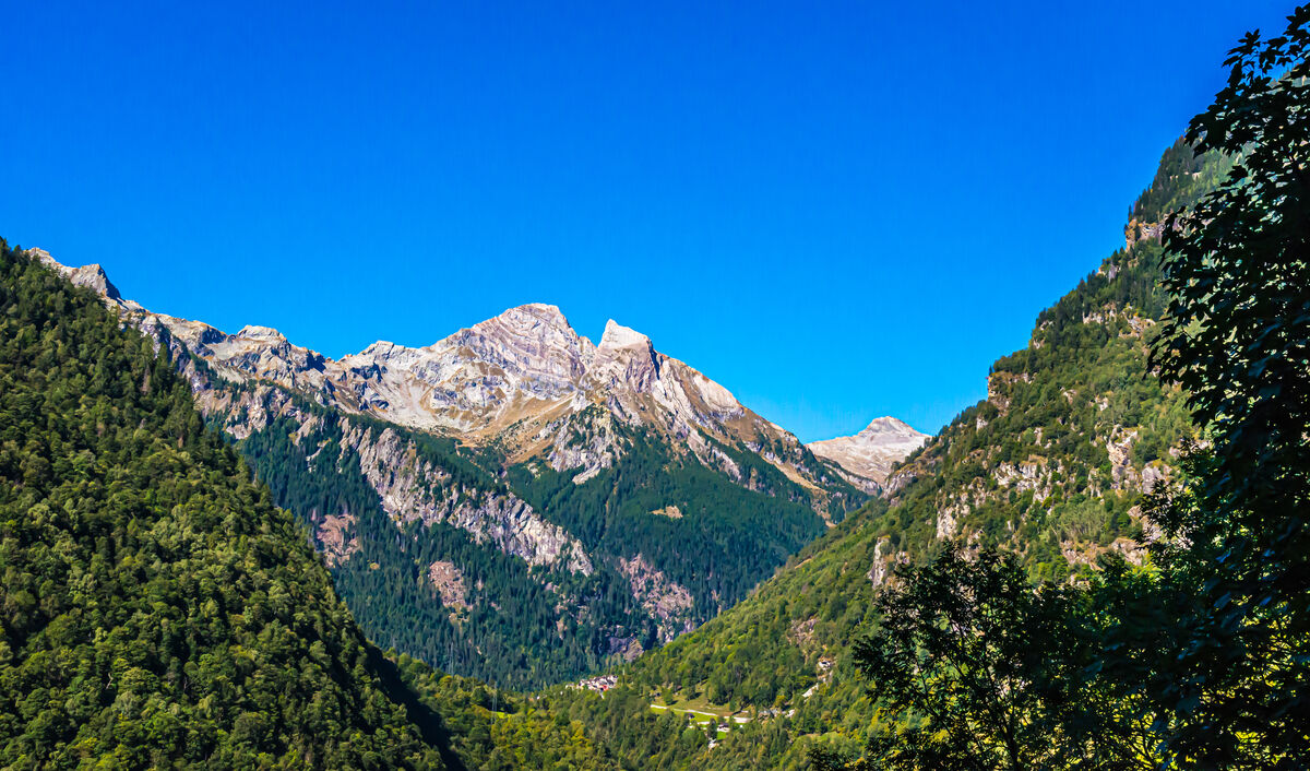
(Download)
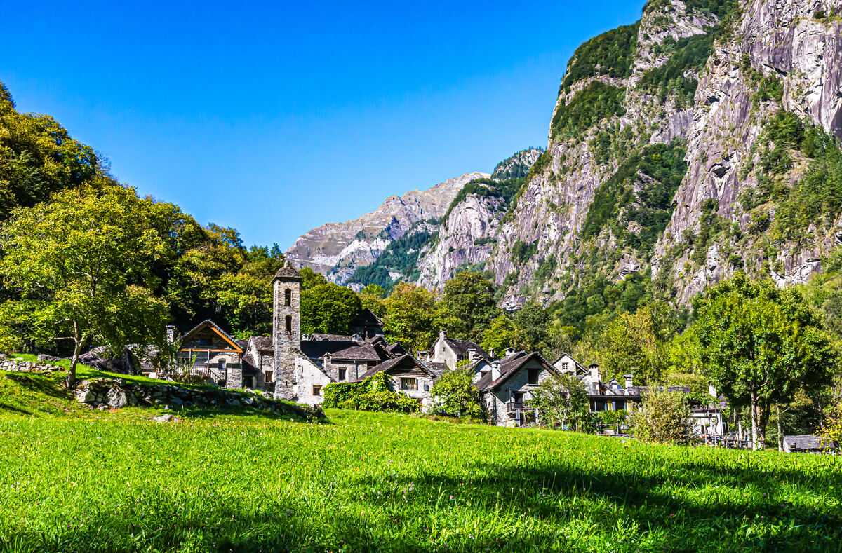
6 - Ticino/Fusio - Typical Ticinesi mountain village located at the uppermost reaches of the Valle Maggia, at center-right the church Santa Maria Assunta (1935)
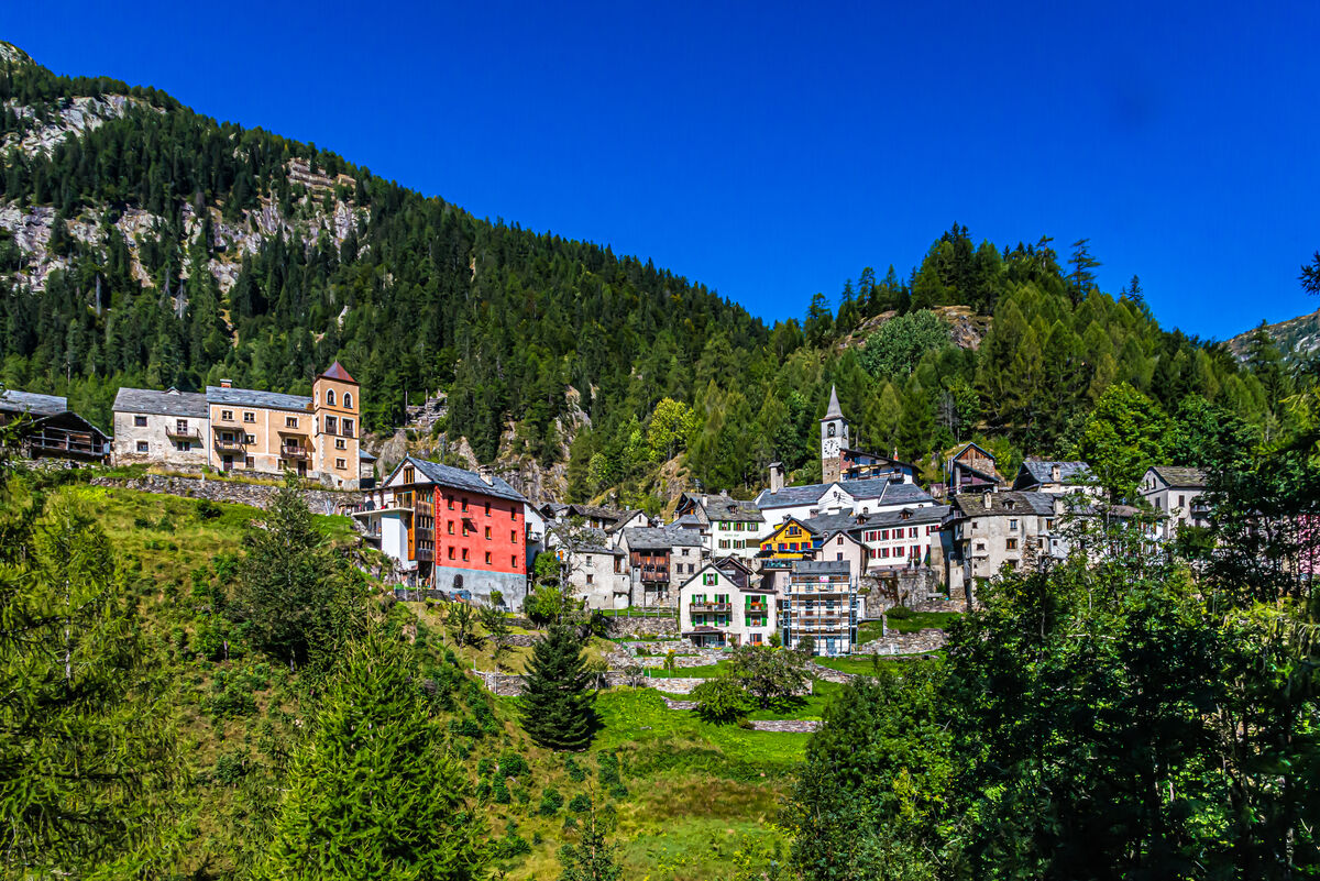
(Download)
7 - Ticino/Fusio - Historic rough-hewn wooden storage houses with slate roofs
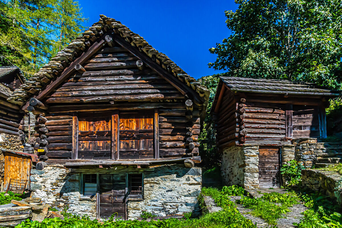
(Download)
8 - Ticino/Cevio - Oratorio Santa Catarina (17c) in the small hamlet Ritorto in the quiet, remote Bavona Valley, at rear left the Foroglio water fall, the most spectacular fall in the Ticino
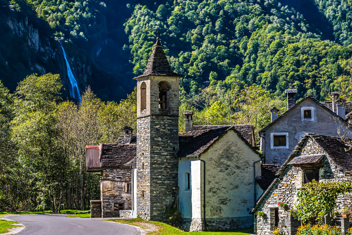
(Download)
9 - Ticino/Cevio - The tiny village of Foroglio in the quiet, remote Bavona Valley, that has given Ticino's most spectacular water fall its name
(Download)
10 - Ticino/Blenio - View of the town of Blenio (formerly Olivone) from the Lucomagno (Lukmanier) Pass route connecting the Italian speaking Ticino with the German speaking Grison with the massive Sosto peak (2221m/7287ft) closing off the valley
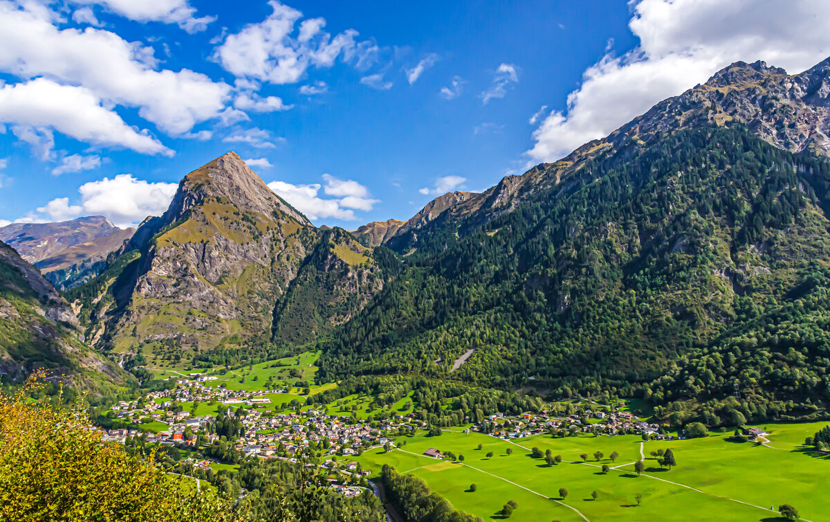
(Download)
Jan 30, 2024 09:56:52 #
For your reference:
Map of Switzerland indicating in the lower center the location of the places shown in this set
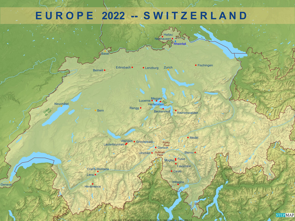
(Download)
Jan 30, 2024 10:23:21 #

Jan 30, 2024 10:25:15 #

Jan 30, 2024 10:51:52 #
Jan 30, 2024 11:17:59 #

Jan 30, 2024 13:13:24 #

Jan 30, 2024 18:19:42 #
NMGal wrote:
Beautiful tour, Joe.
Thank you Barbara, I am happy to hear that you enjoyed this mountain plus old buildings set.
Jan 30, 2024 18:20:22 #
roder10 wrote:
All I can say - Spectacular!!!!
Thank you Rowedean for your kind words of appreciation.
Jan 30, 2024 18:21:10 #
kpmac wrote:
Beautiful.
Thank you Ken - I am happy to hear that you find these images beautiful
Jan 30, 2024 18:21:41 #
Earnest Botello wrote:
Another great and beautiful series, Joe.
Thank you very much Earnest for your kind words.
Jan 30, 2024 18:22:17 #
UTMike wrote:
What a beautiful place to grow up visiting, Joe!
Thanks Mike, yes, I developed a life-long love for that area!
Jan 30, 2024 19:39:09 #
Jan 30, 2024 20:34:03 #
PAR4DCR wrote:
Another awesome set Joe.
Don
Don
Thank you Don, I have to admit I was very happy standing on top of that Nufenen Pass and seeing these mountain peaks so clear. I cannot remember that vista from previous years, but it has been decades since I last crossed that mountain pass - and all it takes is a few clouds in the wrong spot to hide away all that beauty. And I am always very happy to be down in the canton of Ticino with all these ancient stone buildings, it is sort of almost like heaven to me! Thanks for appreciating these shots, Don!
Jan 30, 2024 21:17:21 #
lnl
Loc: SWFL
I can’t imagine letting a 14 year old bike 170 km alone through the mountains. Times surely have changed! Was your grandfather’s native language Italian or Swiss German? (Or something else—your family is very multi-lingual).
The scenery is magnificent. I bet when you were riding your bike you couldn’t even appreciate it. Thanks for the story.
The scenery is magnificent. I bet when you were riding your bike you couldn’t even appreciate it. Thanks for the story.
If you want to reply, then register here. Registration is free and your account is created instantly, so you can post right away.