Help with unknown aerial photo
Nov 20, 2012 14:07:34 #

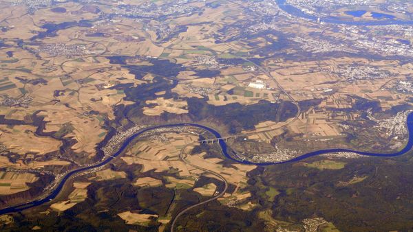
We were on a flight from Paris to Warsaw which is just over two hours flight time. This was taken 30-45 minutes after take off. I was sitting on the left side of the plane so this is looking north. I am trying to identify the bridge. Obviously, I have increased the contrast with Photoshop. Any help would be appreciated. Thanks
Bridge
Nov 21, 2012 09:05:09 #
Never mind. I found it. It is the Moseltalbrucke or Mosel tall bridge over the Mosel river, Dieblick, Germany.
Nov 21, 2012 10:19:37 #

argusfoto wrote:
We were on a flight from Paris to Warsaw which is just over two hours flight time. This was taken 30-45 minutes after take off. I was sitting on the left side of the plane so this is looking north. I am trying to identify the bridge. Obviously, I have increased the contrast with Photoshop. Any help would be appreciated. Thanks
Even though you found the answer yourself, I'll reply anyway.
In cases like this, I have found Google Earth a great resource. Two years ago, we visited Jamaica, and of course ended up with a bunch of photos of which no-one remembered where they were taken.
But if you know an approximate area, as you did here, some landmarks are so visible on Google Earth that, while it may be time-consuming, it is not hard to find them.
EstherP
Nov 21, 2012 12:26:48 #
Nov 25, 2012 22:46:27 #
Botann
Loc: SE of Seattle
I spend hours on Google Earth, but then, I'm a map freak. I can go anywhere I want. It's fun to look up places I've been, just like you argusphoto. ....And places I'd like to go to.
Mike
Mike
Nov 25, 2012 23:17:45 #
Unfortunately, GPS does not work when you are going more than 300mph. ;-)
You will appreciate this, Botann.
We had clear weather all the way from Birmingham to NY. I took many pictures and located them on Google maps. Click "map this" upper right to see where they are.
http://wallyworld.smugmug.com/Travel/United-States/BHM-to-LGA-and-back/10548896_2wqZb5#!i=732619437&k=PRou3
Nov 25, 2012 23:47:38 #
argusfoto wrote:
Never mind. I found it. It is the Moseltalbrucke or Mosel tall bridge over the Mosel river, Dieblick, Germany.
Never noticed this before, call me picky if you like, but the name of the bridge in English is Mosel Valley Bridge.
EstherP
Nov 26, 2012 07:11:07 #
Botann
Loc: SE of Seattle
Argusphoto, that was fun! I spent almost an hour playing with it.
Great pictures of New York City!
I spent a week in lower Manhattan about 12 years ago.
You were very lucky to have such nice weather for taking pictures.
Great pictures of New York City!
I spent a week in lower Manhattan about 12 years ago.
You were very lucky to have such nice weather for taking pictures.
Nov 26, 2012 08:52:43 #
You are right. I should know better. "Tal" is German for valley. Although it is a tall bridge. ;-)
Being accurate is not picky.
Being accurate is not picky.
Nov 26, 2012 09:06:34 #

Botann wrote:
I spend hours on Google Earth, but then, I'm a map freak. I can go anywhere I want. It's fun to look up places I've been, just like you argusphoto. ....And places I'd like to go to.
Mike
Mike
Ah, this addiction can be further poked with this book: Maphead by Jennings.

Nov 26, 2012 09:31:18 #
Even though this is getting somewhat off topic, map freaks should check out http://bigthink.com/blogs/strange-maps
Now let's get back to photography.
Now let's get back to photography.
Nov 26, 2012 10:16:59 #
argusfoto wrote:
....
We had clear weather all the way from Birmingham to NY. I took many pictures and located them on Google maps. Click "map this" upper right to see where they are.
http://wallyworld.smugmug.com/Travel/United-States/BHM-to-LGA-and-back/10548896_2wqZb5#!i=732619437&k=PRou3
We had clear weather all the way from Birmingham to NY. I took many pictures and located them on Google maps. Click "map this" upper right to see where they are.
http://wallyworld.smugmug.com/Travel/United-States/BHM-to-LGA-and-back/10548896_2wqZb5#!i=732619437&k=PRou3
OK, I have not looked at SmugMug for eons and did not know about this feature that combines your photos with the map in "map this." THAT was impressive. What a terrific feature for displaying your pix! And for shots through a plane window, they were pretty clear. Must not have had much dirt on them. Nice travel/pix log. Thanks for sharing this terrific idea for linking pix with maps.
Nov 26, 2012 13:02:13 #
Even if the airplane window is clean, it is necessary to use Photoshop to increase contrast. The location is always manual from a jet plane. The time stamp is a big help in determining the location. From 30K ft you can see about 60 miles so it can be a challenge.
If you have a camera like the Panasonic Lumix ZS7 which has built in GPS or Nikon 1 V1 which has a GPS attachment, the info is in the EXIF data and is automatic on Smugmug.
a couple of examples:
http://wallyworld.smugmug.com/Travel/Spain/Torremolinos-Spain-15-22-Oct/26340909_rrpbXS#!i=2202868973&k=TZbxHKV
http://wallyworld.smugmug.com/Travel/Portugal/Lisbon-Portugal/14315979_2v297P#!i=1059369925&k=nRTvgMC
I wish my 60D had built in GPS
Nov 26, 2012 16:56:28 #
Quote:
I wish my 60D had built in GPS[/quote]
Yes, that is the one thing I compromised on for this sweet camera. Your are right about needing some processing, but yours came out quite nicely and that is a wonderful tool. I often put waypoints in my GPS to correspond with stuff or for total laziness, just take pix of relevant signs. Of course, from way up, ya just gotta know the geography. It is fun, however.
Thanks for sharing.
If you want to reply, then register here. Registration is free and your account is created instantly, so you can post right away.