SE West Virginia Travel Help Needed
Jul 14, 2022 15:43:47 #

I have a trip planned for this October starting in Monroe County (in SE West Virginia), working over to the New River Gorge area before returning to NC. But I need some help deciding on which route has better landscape photo ops getting to Union in Monroe County. Coming up I-77 from NC, there would be the second half of the day to get from either Princeton or Blacksburg to Union, so looking for the most scenic route.
The routes I am trying to decide between include:
1-Take I-77 close to around Princeton, WV, and then east on US #460 continuing onto US #219 at Rich Creek to Union;
2-Leave I-77 and get on I-81 to around Christiansburg, VA, and then get on US #460 north and northwest and go up through Blacksburg to Rich Creek, on the VA/WV line, and then pick up US #219 to Union.
3(?)-or possibly VA #100, from Dublin on I-81 thru Pearisburg to Rich Creek, but it looks really winding and slow--unless there are worthwhile photo ops.
The focus of the trip will be to explore old barns, covered bridges, old general stores, grist mills, waterfalls, and scenic landscapes. So these would be the attractions I'd like to find along whichever route I take.
Any photographers who can share their knowledge of the area would be much appreciated. Thanks in advance for taking time to give this some thought!
Jul 15, 2022 08:02:26 #

This state is full of beautiful winding country roads. If you are at New River Gorge NP, which is a great photo spot, make sure you photograph the Glade Creek Grist Mill too. The tree colors should be beautiful but watch for any early snow in the mountains.
Jul 15, 2022 09:53:13 #
h0grider
Loc: Western MD
For covered bridges, Dale Travis' website http://www.dalejtravis.com/cblist/cblistus.htm is a must for planning. I would obtain a road map of the state(s) of interest, then, using Travis' website, mark the approximate location of the bridges along the route I'm traveling, to avoid driving right past a CB without even knowing it was there! There are several CBs in the southern portion of WV, but overall they are scattered throughout the state, so you'll need to know their locations if they are a priority. There are also a few bridges in the SW portion of VA that "might" be worth a side trip if you are close, the Humpback CB being one for sure; it's west of the grist mill mentioned and US route 60 might meet your criteria for "scenic" views (all I remember was that it was very curvy). This method hasn't failed me yet (300+ bridges and counting, including all the WV ones).
Jul 15, 2022 10:06:52 #
h0grider
Loc: Western MD
P.S. Re waterfalls, WV now has a "West Virginia Waterfall Trail" tourist promotion. They have a state map at their website (you'll have to dig around a bit to find it!) showing all the waterfalls in the program (29) and the locations, along with a picture. It's a "passport" type program; document enough waterfalls, win a prize! Perhaps the best of the waterfalls WV has to offer will be on your route (the one at the grist mill is).
Jul 15, 2022 11:58:40 #
ashriverguy wrote:
This state is full of beautiful winding country roads. If you are at New River Gorge NP, which is a great photo spot, make sure you photograph the Glade Creek Grist Mill too. The tree colors should be beautiful but watch for any early snow in the mountains.
Thanks for the heads-up, ashriverguy. Glade Creek is the main reason for the itinerary--that, and Cook's Mill in Monroe County, and Mabry Mill on the way home. Looking forward to good color between the 22nd and 30th--not so much any snow, though, lol!
Jul 15, 2022 12:26:53 #
h0grider wrote:
For covered bridges, Dale Travis' website http://w... (show quote)
Thank you, h0grider. Dale Travis' list of bridges was one of the first I came across when I started building this trip.
WV was planned for 2019 but got postponed twice--third times a charm--so I've had a lot of time to research, lol!
So far, I have the following list of must-sees:
Mills: Glade Creek, Mabry, Cook's, McClungs's, Reed's, McNeel, The Cotton Hill Mill.
Covered Bridges: Sinking Creek (if we come up #460), Laurel Creek, Indian Creek, Hoke's Mill CB, Locust Creek.
Structural Bridges: New River (of course), Cauley River, Train Trestle at Hawk's Nest SP, Earl M Vickers, Alderson, Thurmond.
Waterfalls...too many to list.
Barns: Mail Pouch Barns known to be standing, plus any others that catch the eye driving the backroads.
The trip is limited to Monroe, Fayette, Summers, plus a bit of Nicholas and Raleigh Counties. If you see a notable omission, would be happy to know how to add it to the routing. Thanks again!
Jul 15, 2022 12:36:46 #
h0grider wrote:
P.S. Re waterfalls, WV now has a "West Virginia Waterfall Trail" tourist promotion. They have a state map at their website (you'll have to dig around a bit to find it!) showing all the waterfalls in the program (29) and the locations, along with a picture. It's a "passport" type program; document enough waterfalls, win a prize! Perhaps the best of the waterfalls WV has to offer will be on your route (the one at the grist mill is).
I have been using 'Waterfalls of Virginia & West Virginia' guidebook by Randall Sanger for planning this itinerary. I have the list down to those that are no mare than 1/4" hike or roadside--my travel buddy and I just can't do the long hikes or scrambling any more. That said, I still have a LOT on the list.

Don't know if you do Facebook, but I follow Bob Bell's 'Driving Backroads' and he has suggested that Hwy.100 up from Dublin to Rich Creek would be the most scenic route to take coming up from NC to Monroe County, WV. Have you ever traveled that road with photography in mind?
Jul 16, 2022 12:40:29 #
h0grider
Loc: Western MD
dmeyer wrote:
...that Hwy.100 up from Dublin to Rich Creek would be the most scenic route to take coming up from NC to Monroe County, WV. Have you ever traveled that road with photography in mind?
Couldn't find the highway (or locations) referenced, but I'm not much into planning "scenic" routes, just bridge hunting, which if I happen to see a nice view, I stop.
I see you plan on visiting the Hoke's Mill CB in Greenbrier county in WV. If it works into your itinerary, you might want to try to pick up the Herns Mill CB in the same county; perhaps the "alligator" that was under the bridge 15 years ago is still there (see crappy pic from a malfunctioning point-and-shoot of that era)!
I think the Laurel Creek CB in Monroe county WV you plan to visit is the "cutest" (and I believe shortest) of all of the WV bridges. As a plus it's out in the country in a scenic area to boot!
FYI, I've never found the GPS coordinates from Dale Travis' website to fail me when navigating to the bridges and use them exclusively when out "bridging."
Jul 16, 2022 15:02:05 #

Jul 16, 2022 19:30:14 #
h0grider wrote:
Couldn't find the highway (or locations) reference... (show quote)
Very good point of having the GPS coordinates from Dale's guide--I have his list printed and in my travel notebook. I forget sometimes that I can enter GPS on my Garmin. I did include Hern's Mill in the itinerary--thanks! If Laurel Creek doesn't prove to be too far from where our lodging is, I would love to do a Milky Way with some illumination in the bridge. By October, the MW will be just after sunset, so a possibility. Getting eager to see these places!
Jul 16, 2022 21:42:26 #
Visit Glade creek for sure but only if there has been enough recent rainfall to flow over the paddle wheel, thats if you want a truly spectacular image. Also, for any scinic vistas in the areas you wish to visit do a fall foilage update report search for those areas. That brings me back to the Glade creek grist mill. I was there in mid April two years ago and the leaves were still mostly green and the creek that normally feeds the paddle wheel was bone dry. Naturally it rained/poured all the way home starting when I crossed into Kentuckey. ARGH!
Jul 17, 2022 05:40:16 #
usnret wrote:
Visit Glade creek for sure but only if there has b... (show quote)
Mid April--or Mid October when you went? Booking reservations for trips is always a game of chance when it comes to weather and foliage. But we have lots of varied subjects to hunt for and hopefully will reel in at least one big fish!
Jul 18, 2022 17:02:24 #
h0grider
Loc: Western MD
dmeyer wrote:
... If Laurel Creek doesn't prove to be too far from where our lodging is, I would love to do a Milky Way with some illumination in the bridge. By October, the MW will be just after sunset, so a possibility. Getting eager to see these places!
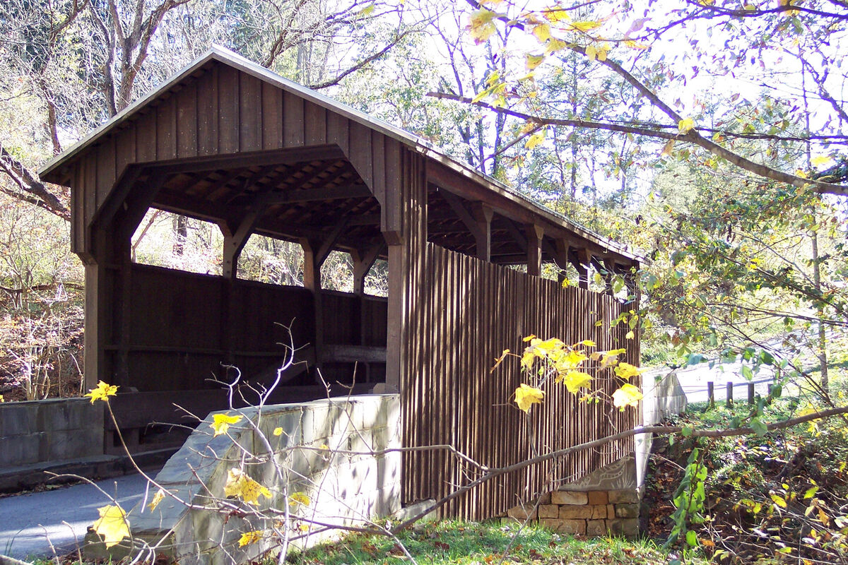
Here's a pic of the Laurel Creek CB, the one you're thinking about for Milky Way shots. This was taken mid-October, around 1:30 in the afternoon, so south would be roughly off the backside corner of the bridge, I would think. This bridge is located in a "bowl," but the higher side is along and over to the your left from this position. Shot was taken standing in someone's yard, as there is, if I recall correctly, only a little space to step off on the other side of the road from the bridge (fence and what not). Also, there are 2 or 3 houses right here, one back behind from where this shot was taken.
Foliage was iffy in mid-October when my bridge trip happened. Some of the trees had color, some had come and gone (as evidenced in the picture), but in lower elevations the trees were still pretty green in a lot of the pics from this same trip.
Can't wait to see some posts of the end result of the road trip!

Jul 18, 2022 17:44:47 #
h0grider wrote:
Here's a pic of the Laurel Creek CB, the one you'r... (show quote)
Thanks so much for sharing the bridge and its orientation--that is really helpful. The MW will be WSW in October, so the trees behind and to the right may interfere with the core as close as they are. Guess I better start pulling up Google Earch on some of the other bridges and barns to find a lower horizon in the background.
Jul 19, 2022 07:57:45 #
skipwv
Loc: West Virginia
dmeyer wrote:
I have a trip planned for this October starting in... (show quote)
My favorite would be 460 and 219 from Princeton. 219 near Union has many nice farm scenes. If you have time, try to spend some time on WV Rt. 12, too. Alderson and Pence Springs are quaint little towns and east of Hinton it passes the Big Bend Tunnel and a memorial to John Henry. Of course, you will want to visit Babcock State Park for the grist mill! Randall Sanger’s books on West Virginia waterfalls are great, offering photos and detailed, specific directions to dozens of photogenic falls. Have a great time in our Mountain State!
If you want to reply, then register here. Registration is free and your account is created instantly, so you can post right away.