S & E Asia 114 - Myanmar 54: Inle Lake 1 - Flying over colorful fields in Shan State
Jun 26, 2022 11:01:55 #

The texts on this page serve as an introduction to the INLE LAKE area and will be referenced on the subsequent post covering the Inle Lake and its surroundings. As usual, these are a substantially condensed version of the information presented mainly on Wikipedia.
SHAN STATE (ရှမ်းပြည်နယ်) also known by the endonyms Shanland, Muang Tai, and Tailong, is a state of Myanmar. It borders CHINA to the north, LAOS to the east, and THAILAND to the south, and five administrative divisions of Myanmar in the west. The largest of the 14 administrative divisions by land area, Shan State covers 155,800 km², almost a quarter of the total area of Myanmar. The state gets its name from Burmese name for the Tai people: "Shan people". The Tai (Shan) constitute the majority among several ethnic groups that inhabit the area. Shanland is largely rural, with only three cities of significant size, including the capital, Taunggyi. Taunggyi is 150 km northeast of the nation's capital Naypyitaw.
Shan state, with many ethnic groups, is home to several ethnic armies. While the military government has signed ceasefire agreements with most groups, vast areas of the state, especially those in the east, remain outside the central government's control, and in recent years have come under heavy ethnic-Han Chinese economic and political influence. Other areas are under the control of military groups such as the Shan State Army.
According to data from the United Nations Office on Drugs and Crime (UNODC), Shan State is the region that produces the most opium in Myanmar, accounting for 82% (331 metric tons) of the country's total output (405 metric tons) in 2020. That said, opium poppy cultivation has declined year-on-year since 2015. In 2020, cultivation in Shan State declined a further 12%.
INLE LAKE (အင်းလေးကန်), a shallow freshwater body located in a part of Shan Hills, is the second largest lake in Myanmar with an estimated surface area of 116 km², (45 sq mi) and one of the highest at an elevation of 880 m (2,900 ft). During the dry season, the average water depth is 2.1 m (7 ft), with the deepest point being 3.7 m (12 ft). During the rainy season, this can increase by 1.5 m (5 ft). The watershed area for the lake lies to the north and west of the lake. The lake drains through the Nam Pilu River on its southern end.
Large sections of the lake are covered by floating plants. Its clear and slightly alkaline waters are home to a diverse fauna and many species found nowhere else in the world (endemics). There are more than 35 native species of fish, including 17 endemics. Some of these are of minor commercial importance for the aquarium trade. Several fish that are not native have been introduced. Additionally, the lake is home to about 45 species of freshwater snails, 30 of them endemic, along with a small endemic freshwater crab. It hosts approximately 20,000 migratory gulls in November to January.
In June 2015, it became Myanmar's first designated place of World Network of Biosphere Reserves. Today the lake's environment is under serious pressure due to pollution, siltation, eutrophication, overfishing and introduced species, including the highly invasive water hyacinth.
People and culture - The people of Inle Lake live in four cities and numerous small villages along the lake's shores, and on the lake itself. The population consists predominantly of Intha, with a mix of other ethnicities. Most are devout Buddhists and live in simple houses of wood and woven bamboo on stilts; they are largely self-sufficient farmers.
Transportation on the lake is traditionally by small boats, or by somewhat larger boats fitted with single cylinder inboard diesel engines. Local fishermen are known for practicing a distinctive rowing style which involves standing at the stern on one leg and wrapping the other leg around the oar. This unique style evolved out of necessity as the lake is covered by reeds and floating plants, making it difficult to see above them while sitting. Standing provides the rower with a view beyond the reeds. However, the leg rowing style is only practiced by the men. Women row in the customary style, using the oar with their hands, sitting cross legged at the stern.
Fish caught from the lake have been a staple of the local diet. The Inle carp has historically been the most abundant but today is seriously threatened. A popular local dish is htamin gyin - 'fermented' rice kneaded with fish and/or potato - served with 'twice-fried Shan tofu'. In addition to fishing, locals grow vegetables and fruit in large gardens that float on the surface of the lake. The floating garden beds are formed by extensive manual labor. The farmers gather up lake-bottom weeds from the deeper parts of the lake, bring them back in boats and make them into floating beds in their garden areas, anchored by bamboo poles. These gardens rise and fall with changes in the water level, and so are resistant to flooding. The constant availability of nutrient-laden water results in these gardens being incredibly fertile. Rice cultivation and consumption is also a significant facet of the local diet and agricultural tradition.
-------------------------------------------------------------------------------------------------------------------------------
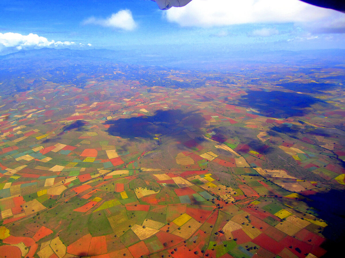
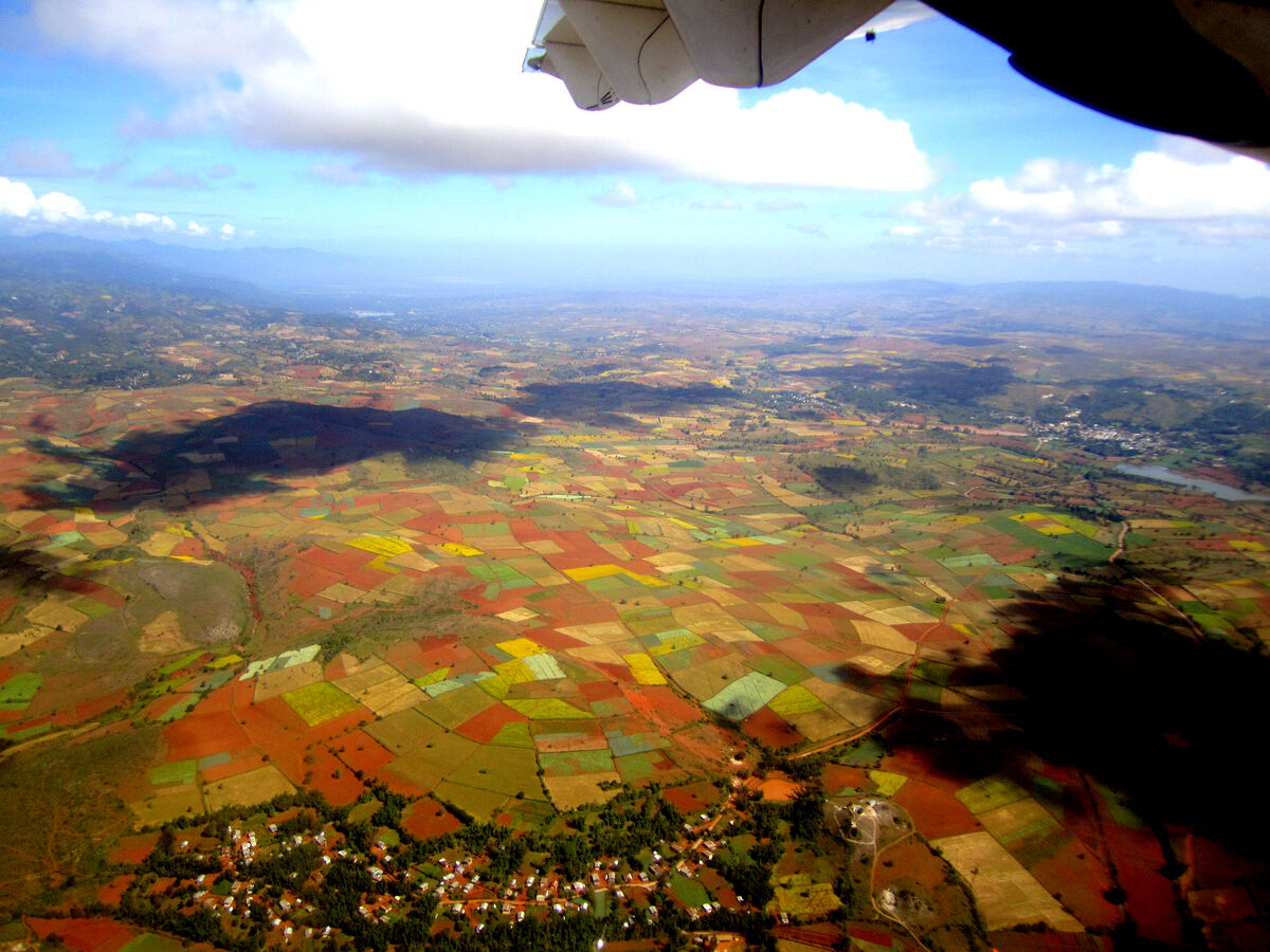
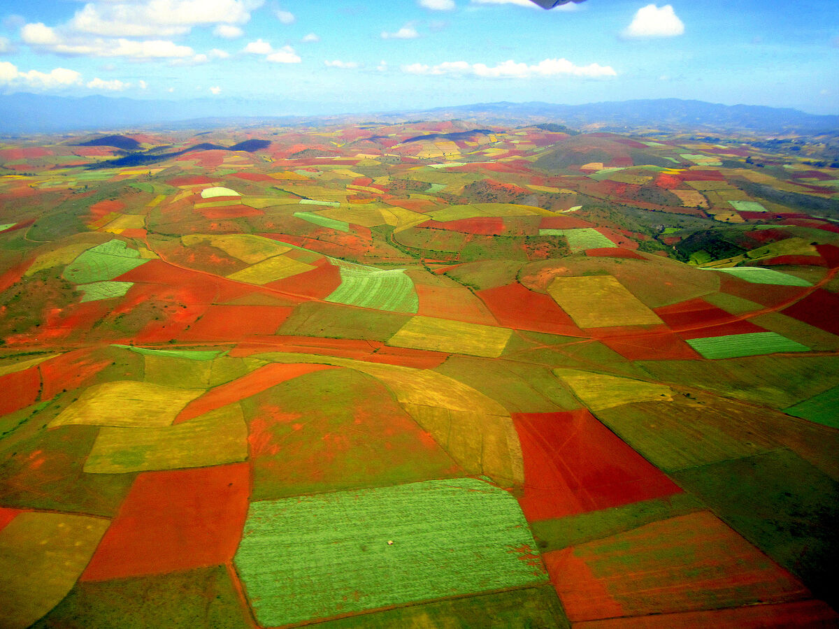
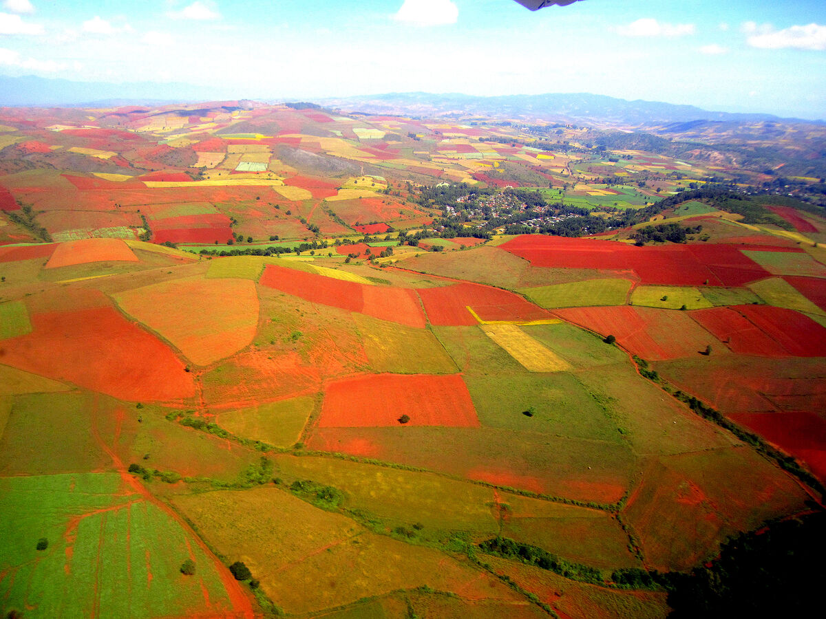
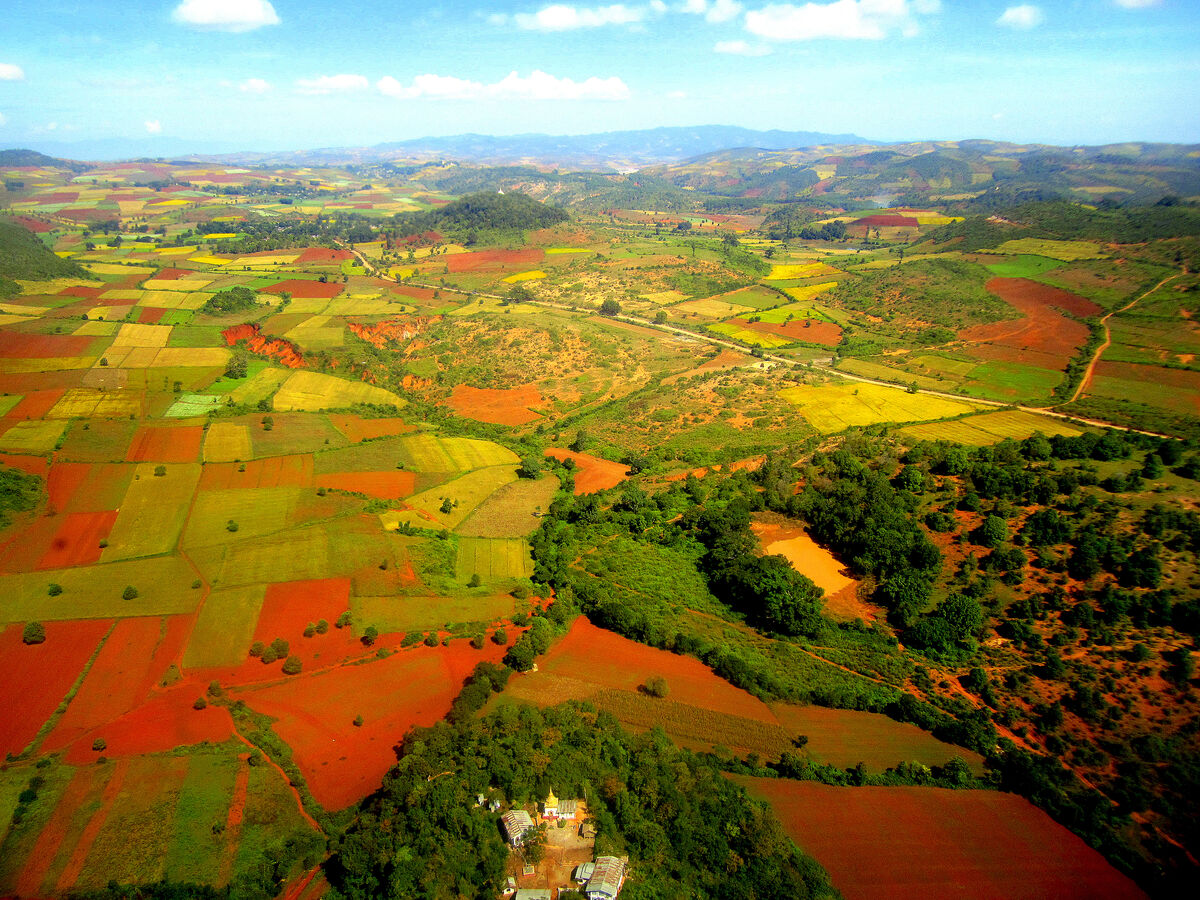
Almost all of the images in this introductory set were taken as we were in a relatively low orbit covering the short distance of 135 km (84 mi) between Mandalay and Heho (airport for the city of Taunggyi) in an ATR 72-600 aircraft of the domestic Air Kanbawza airline. Due to the low orbit, we had a spectacularly close view over the strongly multicolored checkerboard fields, with the dominant red of the local soil adding a striking contrast to the greens and yellows of the crops.
Notes
TRIP INFO: Set # 1 provides a brief introduction to THIS SERIES on SOUTH & EAST ASIA. See it at
https://www.uglyhedgehog.com/t-724330-1.html
MYANMAR COUNTRY INFO in set # 61: https://www.uglyhedgehog.com/t-731087-1.html
EARLIER POSTS of this series: Access my topic list at UHH, the new posts are listed in reverse chronological order:
https://www.uglyhedgehog.com/user-topic-list?usernum=45105
Thanks for visiting, I recommend viewing the downloads and look forward to your comments and questions.
.
SHAN STATE (ရှမ်းပြည်နယ်) also known by the endonyms Shanland, Muang Tai, and Tailong, is a state of Myanmar. It borders CHINA to the north, LAOS to the east, and THAILAND to the south, and five administrative divisions of Myanmar in the west. The largest of the 14 administrative divisions by land area, Shan State covers 155,800 km², almost a quarter of the total area of Myanmar. The state gets its name from Burmese name for the Tai people: "Shan people". The Tai (Shan) constitute the majority among several ethnic groups that inhabit the area. Shanland is largely rural, with only three cities of significant size, including the capital, Taunggyi. Taunggyi is 150 km northeast of the nation's capital Naypyitaw.
Shan state, with many ethnic groups, is home to several ethnic armies. While the military government has signed ceasefire agreements with most groups, vast areas of the state, especially those in the east, remain outside the central government's control, and in recent years have come under heavy ethnic-Han Chinese economic and political influence. Other areas are under the control of military groups such as the Shan State Army.
According to data from the United Nations Office on Drugs and Crime (UNODC), Shan State is the region that produces the most opium in Myanmar, accounting for 82% (331 metric tons) of the country's total output (405 metric tons) in 2020. That said, opium poppy cultivation has declined year-on-year since 2015. In 2020, cultivation in Shan State declined a further 12%.
INLE LAKE (အင်းလေးကန်), a shallow freshwater body located in a part of Shan Hills, is the second largest lake in Myanmar with an estimated surface area of 116 km², (45 sq mi) and one of the highest at an elevation of 880 m (2,900 ft). During the dry season, the average water depth is 2.1 m (7 ft), with the deepest point being 3.7 m (12 ft). During the rainy season, this can increase by 1.5 m (5 ft). The watershed area for the lake lies to the north and west of the lake. The lake drains through the Nam Pilu River on its southern end.
Large sections of the lake are covered by floating plants. Its clear and slightly alkaline waters are home to a diverse fauna and many species found nowhere else in the world (endemics). There are more than 35 native species of fish, including 17 endemics. Some of these are of minor commercial importance for the aquarium trade. Several fish that are not native have been introduced. Additionally, the lake is home to about 45 species of freshwater snails, 30 of them endemic, along with a small endemic freshwater crab. It hosts approximately 20,000 migratory gulls in November to January.
In June 2015, it became Myanmar's first designated place of World Network of Biosphere Reserves. Today the lake's environment is under serious pressure due to pollution, siltation, eutrophication, overfishing and introduced species, including the highly invasive water hyacinth.
People and culture - The people of Inle Lake live in four cities and numerous small villages along the lake's shores, and on the lake itself. The population consists predominantly of Intha, with a mix of other ethnicities. Most are devout Buddhists and live in simple houses of wood and woven bamboo on stilts; they are largely self-sufficient farmers.
Transportation on the lake is traditionally by small boats, or by somewhat larger boats fitted with single cylinder inboard diesel engines. Local fishermen are known for practicing a distinctive rowing style which involves standing at the stern on one leg and wrapping the other leg around the oar. This unique style evolved out of necessity as the lake is covered by reeds and floating plants, making it difficult to see above them while sitting. Standing provides the rower with a view beyond the reeds. However, the leg rowing style is only practiced by the men. Women row in the customary style, using the oar with their hands, sitting cross legged at the stern.
Fish caught from the lake have been a staple of the local diet. The Inle carp has historically been the most abundant but today is seriously threatened. A popular local dish is htamin gyin - 'fermented' rice kneaded with fish and/or potato - served with 'twice-fried Shan tofu'. In addition to fishing, locals grow vegetables and fruit in large gardens that float on the surface of the lake. The floating garden beds are formed by extensive manual labor. The farmers gather up lake-bottom weeds from the deeper parts of the lake, bring them back in boats and make them into floating beds in their garden areas, anchored by bamboo poles. These gardens rise and fall with changes in the water level, and so are resistant to flooding. The constant availability of nutrient-laden water results in these gardens being incredibly fertile. Rice cultivation and consumption is also a significant facet of the local diet and agricultural tradition.
-------------------------------------------------------------------------------------------------------------------------------
Almost all of the images in this introductory set were taken as we were in a relatively low orbit covering the short distance of 135 km (84 mi) between Mandalay and Heho (airport for the city of Taunggyi) in an ATR 72-600 aircraft of the domestic Air Kanbawza airline. Due to the low orbit, we had a spectacularly close view over the strongly multicolored checkerboard fields, with the dominant red of the local soil adding a striking contrast to the greens and yellows of the crops.
Notes
TRIP INFO: Set # 1 provides a brief introduction to THIS SERIES on SOUTH & EAST ASIA. See it at
https://www.uglyhedgehog.com/t-724330-1.html
MYANMAR COUNTRY INFO in set # 61: https://www.uglyhedgehog.com/t-731087-1.html
EARLIER POSTS of this series: Access my topic list at UHH, the new posts are listed in reverse chronological order:
https://www.uglyhedgehog.com/user-topic-list?usernum=45105
Thanks for visiting, I recommend viewing the downloads and look forward to your comments and questions.
.
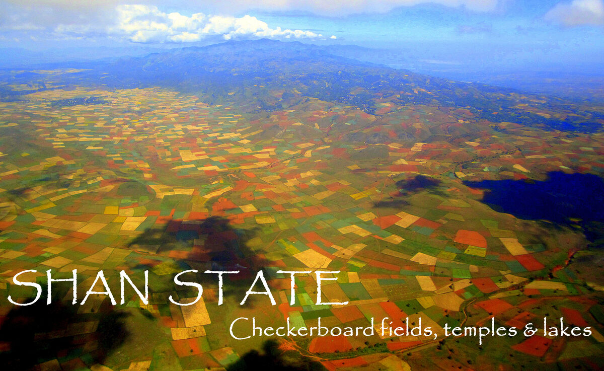
1 - Title page from my album for the Shan State / Inle Lake segment of our tour in Myanmar, showcasing the strong colors of the crops contrasted by the bare patches with its signature red soil
(Download)
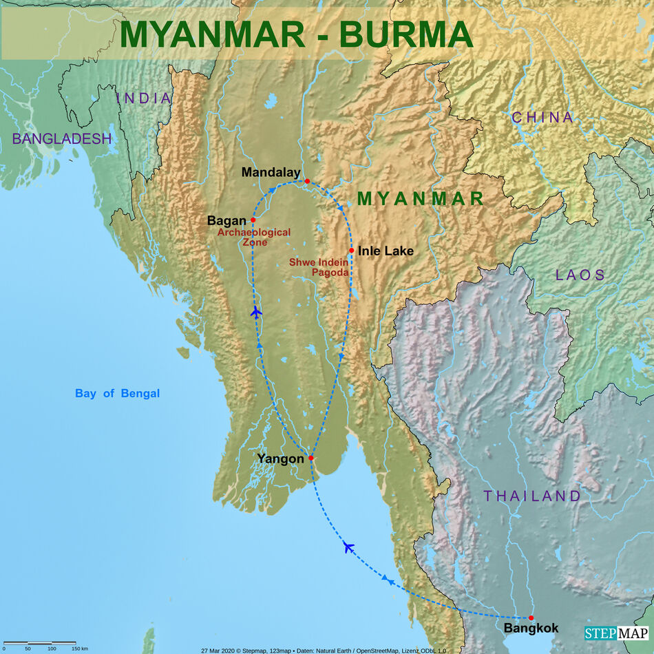
2 - Trip map of the Myanmar segment of our tour
(Download)
3 - Flying over a quiltwork of mainly treeless fields interspersed with villages uniformly set in a treed environment and mountains at the horizon

(Download)
4 - While in the previous image we could not see any trees among the fields, here the area is slightly dotted with trees
(Download)
5 - With the hues slightly subdued, we notice a small lake at right and get a good aerial view of a village at the lower edge
(Download)
6 - Capturing the colors at their strongest expression, we notice that the area is slightly hilly with still higher hills at the horizon
(Download)
7 - Another view with slightly ondulating hills and a distinct village view
(Download)
8 - Our final aerial view as the aircraft descends provides us quite a clear sight of the fields and trees as well as a small compound with a golden pagoda at the lower edge
(Download)
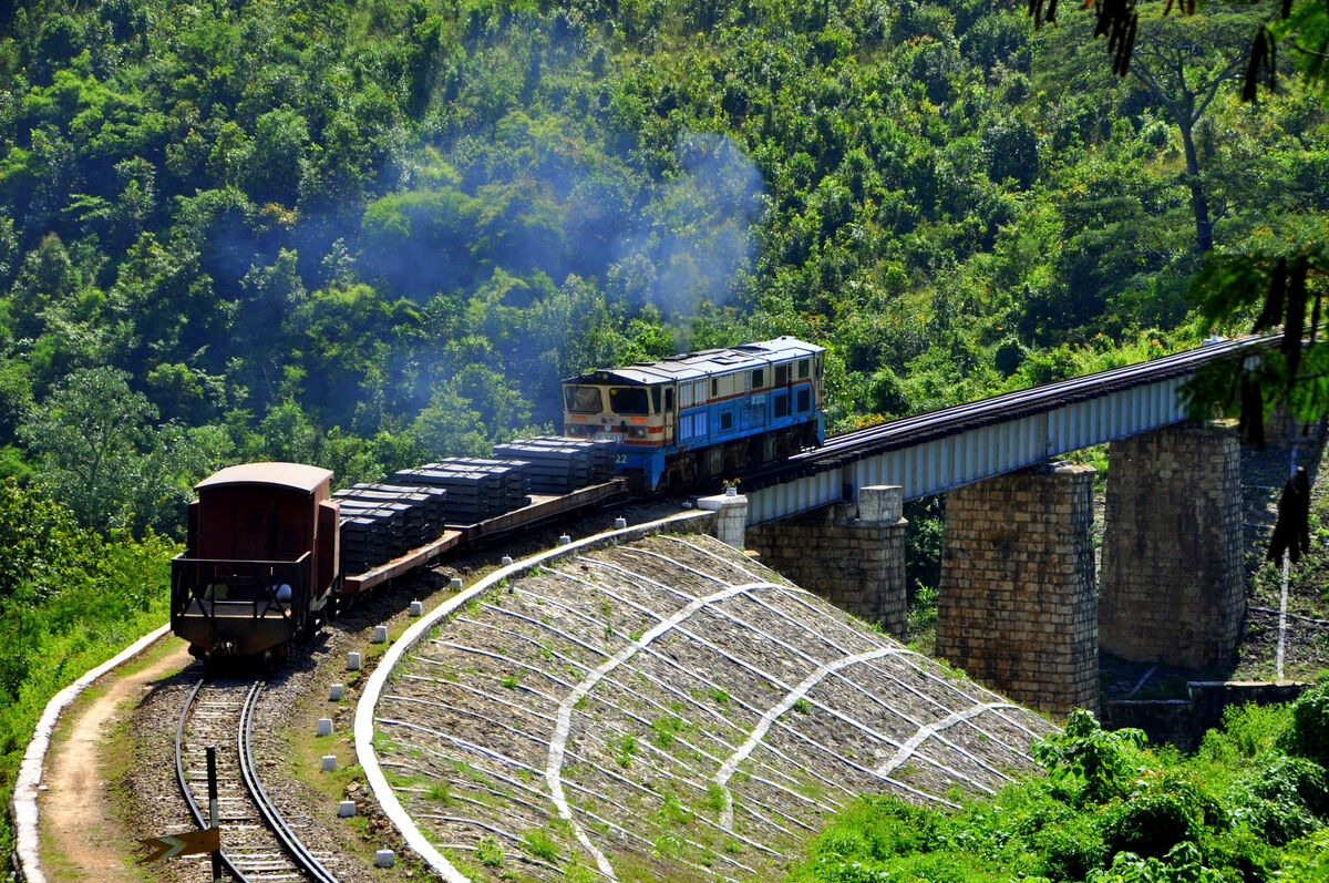
9 - A rickety old train transporting some goods on two flatbed cars is approaching a bridge in a lush green landscape
(Download)
Jun 26, 2022 11:21:06 #

Wow, Joe, this is really a presentation of a "colorful landscape"! Wonderful use of perspective to tell your story.
Jun 26, 2022 11:46:42 #

Great series and great to see you back on the UHH, Joe. I love the colorful landscape.
Jun 26, 2022 11:46:59 #

weberwest wrote:
The texts on this page serve as an introduction to... (show quote)
wow the quilt work pictures are so colorful and beautiful, joe...gorgeous set!
Jun 26, 2022 11:49:42 #

Jun 26, 2022 12:09:46 #
UTMike wrote:
Wow, Joe, this is really a presentation of a "colorful landscape"! Wonderful use of perspective to tell your story.
Thanks Mike, glad to hear that you enjoyed this natural and colorful quilt - I have looked out of plenty aircraft windows but I think this is the most colorful I ever experienced - flying at low altitude due to the short distance definitely also helped.
Jun 26, 2022 12:10:45 #
Earnest Botello wrote:
Great series and great to see you back on the UHH, Joe. I love the colorful landscape.
Thanks you Earnest for your kind comment and the welcome back to UHH - I really appreciate this!
Jun 26, 2022 12:11:40 #
merrytexan wrote:
wow the quilt work pictures are so colorful and beautiful, joe...gorgeous set!
Thank you merry, I am happy to hear that you liked this explosion of colors.
Jun 26, 2022 12:13:27 #
Jun 26, 2022 13:02:44 #

Jun 26, 2022 13:09:29 #
kpmac wrote:
A unique and nicely done set.
Thank you Ken, glad to hear that you like this set.
Jun 26, 2022 14:10:55 #

Jun 26, 2022 14:58:59 #
NMGal wrote:
Colorful, interesting series, Joe.
Thank you Barbara, I am happy to hear that you enjoyed this set.
Jun 27, 2022 06:44:09 #

Jun 27, 2022 07:24:56 #

weberwest wrote:
The texts on this page serve as an introduction to... (show quote)
Outstanding set Joe
If you want to reply, then register here. Registration is free and your account is created instantly, so you can post right away.