My trek within the Grand Canyon
May 15, 2022 11:29:21 #

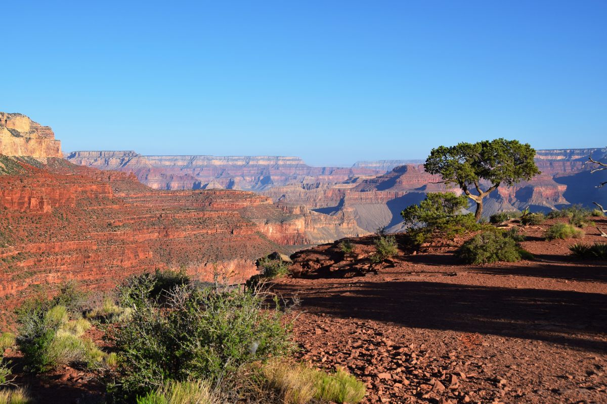
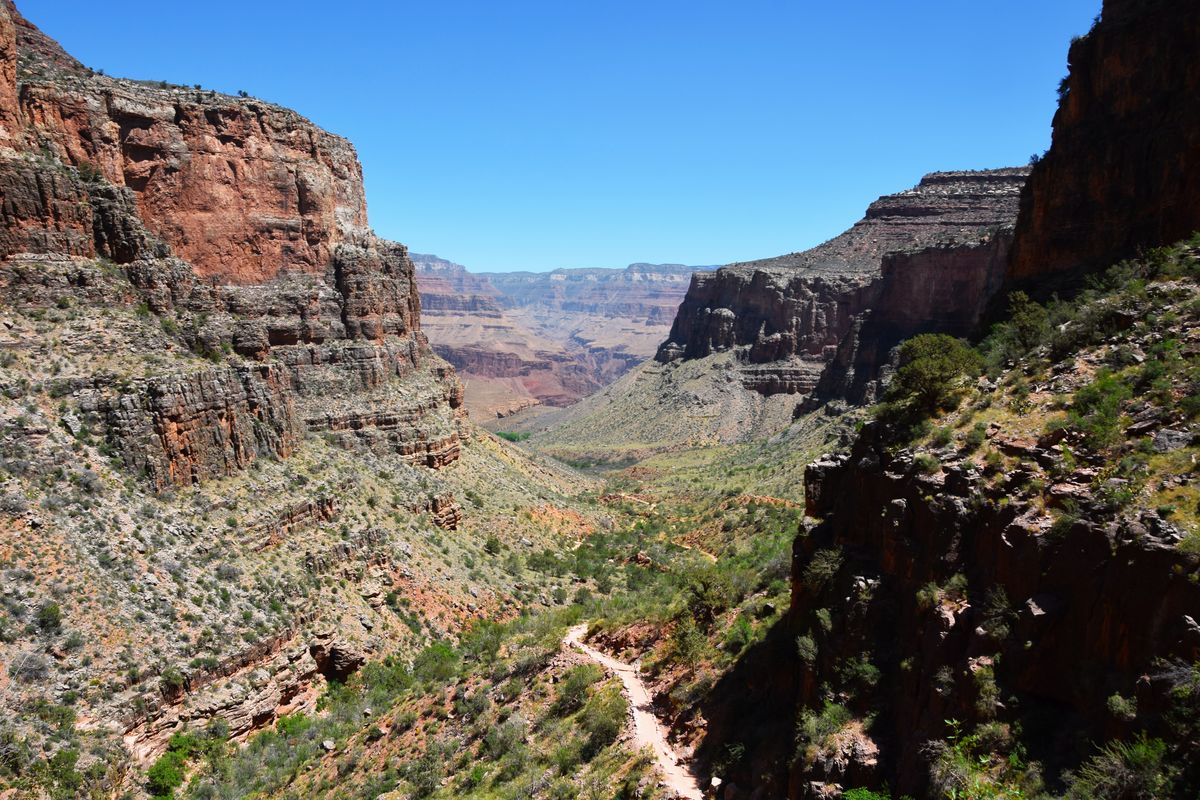
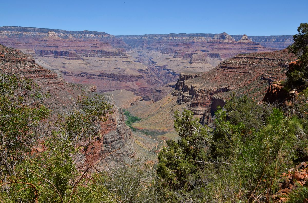
Last week I did the 18 mile loop- started down the South Kaibab trail at 6 A.M., made it to the Colorado River by 9:15, ate lunch, then up the Bright Angel trail. Roughly 9500 feet of elevation change. Took me 7 hours and extremely exhausting, but as many of you know, the views are incredible! Here are a few.
May 15, 2022 11:30:12 #

May 15, 2022 12:10:35 #

May 15, 2022 12:23:22 #

May 15, 2022 12:33:42 #
bikinkawboy
Loc: north central Missouri
Years ago my sister, her fiancé, his three teenage daughters and the girls’ boyfriends hiked to the bottom of the canyon, camped the night and hiked out the next day. Not only did the boyfriends have to carry all of the camping gear, but each girl also had to bring along a mess of cosmetics, several changes of clothes and so on.
The moral of the story is that bringing your daughter’s boyfriend along on vacation may be a pain, but it’s far cheaper than renting a pack mule at the Grand Canyon.
The moral of the story is that bringing your daughter’s boyfriend along on vacation may be a pain, but it’s far cheaper than renting a pack mule at the Grand Canyon.
May 15, 2022 16:12:53 #
May 15, 2022 17:01:16 #

MWojton wrote:
Last week I did the 18 mile loop- started down the South Kaibab trail at 6 A.M., made it to the Colorado River by 9:15, ate lunch, then up the Bright Angel trail. Roughly 9500 feet of elevation change. Took me 7 hours and extremely exhausting, but as many of you know, the views are incredible! Here are a few.
Breathtakingly, eye-catchingly beautiful scenics 💙🧡💛🧡💙
May 15, 2022 22:34:33 #

I've done that trip several times. The South Kaibab Trail is much steeper than the Bright Angel Trail, but somewhat shorter. The nice thing about it is that you aren't completely committed to either one up or down. The Tonto Trail connects horizontally between the two vertical Trails should you change your mind mid-stream, so to speak. I camped at the junction of the Tonto and the South Kaibab one night. At dawn the Mule Train woke us up on the way down. Beautiful, but pretty noisy! Very nice photos BTW!
That green stripe in the bottom of the side canyon with the trail on the left is Indian Gardens on the Bright Angel Trail unless it's been renamed to Indigenous Persons Gardens or some such thing in the last few years.
That green stripe in the bottom of the side canyon with the trail on the left is Indian Gardens on the Bright Angel Trail unless it's been renamed to Indigenous Persons Gardens or some such thing in the last few years.
May 16, 2022 05:39:05 #

MWojton wrote:
Last week I did the 18 mile loop- started down the South Kaibab trail at 6 A.M., made it to the Colorado River by 9:15, ate lunch, then up the Bright Angel trail. Roughly 9500 feet of elevation change. Took me 7 hours and extremely exhausting, but as many of you know, the views are incredible! Here are a few.

May 16, 2022 06:26:55 #

May 16, 2022 07:02:03 #

May 16, 2022 07:54:40 #

Wow! Great landscapes from down in the canyon. I’d love to do that, but can’t. I have photographed from both rims.
May 16, 2022 08:04:55 #

MWojton wrote:
Last week I did the 18 mile loop- started down the South Kaibab trail at 6 A.M., made it to the Colorado River by 9:15, ate lunch, then up the Bright Angel trail. Roughly 9500 feet of elevation change. Took me 7 hours and extremely exhausting, but as many of you know, the views are incredible! Here are a few.
Nice shooting. Less on the way back up! I know a family here in the Atlanta area that did this trip with two kids under 12. The next week, a woman died. Congratulations to you!
May 16, 2022 08:21:14 #

May 16, 2022 08:47:51 #
Retired CPO wrote:
I've done that trip several times. The South Kaiba... (show quote)
It's still called Indian Gardens.
If you want to reply, then register here. Registration is free and your account is created instantly, so you can post right away.