Switzerland: Around Lake Geneva
Jun 18, 2021 17:20:21 #

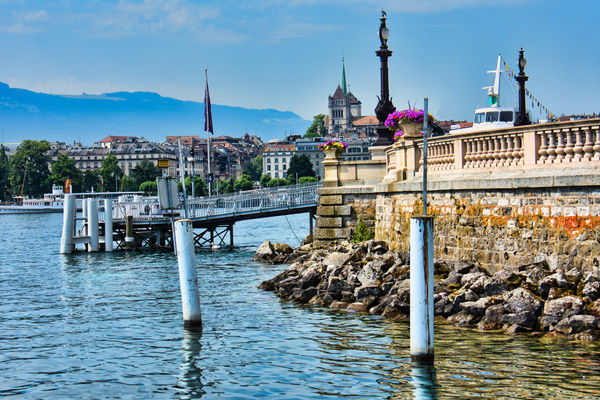
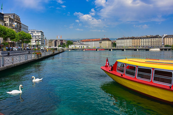
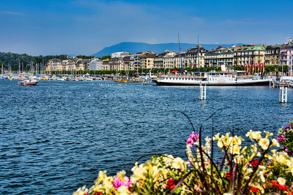
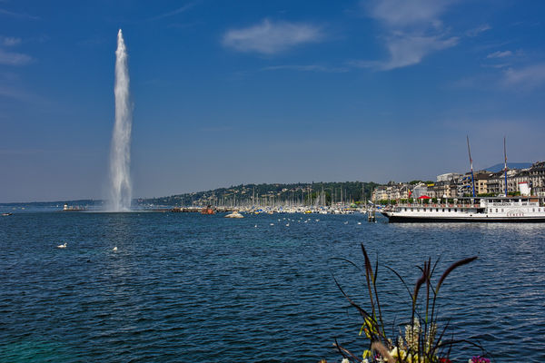
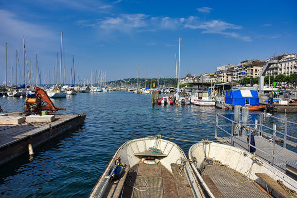
We crossed beautiful Lake Geneva by boat and visited Old Town, then walked back to our hotel, The President Wilson, which is located on the west side of the lake near the United Nations Building. Public transport by boat is provided by the Mouettes Genevoises, which link the two banks of the lake within the city, and by the Compagnie Générale de Navigation sur le lac Léman which serves more distant destinations such as Nyon, Yvoire, Thonon, Évian, Lausanne and Montreux using both modern diesel vessels and vintage paddle steamers.
Lake Geneva (French: le Léman [lə lemɑ̃] (rarely lac de Genève [lak də ʒ(ə)nɛv], lac Léman [lak lemɑ̃]); Italian: Lago Lemano; German: Genfersee [ˈɡɛnfərˌzeː]; Romansh: Lai da Genevra) is a deep lake on the north side of the Alps, shared between Switzerland and France. It is one of the largest lakes in Western Europe and the largest on the course of the Rhône. Sixty per cent (345.31 km2 or 133.32 sq mi) of the lake belongs to Switzerland (the cantons of Vaud, Geneva, and Valais), and forty per cent (234.71 km2 or 90.62 sq mi) to France (the department of Haute-Savoie).
While the exact origins of the name are unknown, the name Lacus Lemanus was in use during the time of Julius Caesar. Lemannus comes from Ancient Greek Liménos Límnē (Λιμένος Λίμνη) meaning "port's lake"; it became Lacus Lausonius, although this name was also used for a town or district on the lake, Lacus Losanetes, and then the Lac de Lausanne in the Middle Ages. Following the rise of Geneva it became Lac de Genève[5] (translated into English as Lake Geneva), but Le Léman was the common name on all local maps and is the customary name in the French language. In contemporary English, the name Lake Geneva has become predominant.
Lake Geneva is divided into three parts because of its different types of formation (sedimentation, tectonic folding, glacial erosion):
Haut Lac (Upper Lake), the eastern part from the Rhône estuary to the line of Meillerie–Rivaz
Grand Lac (Large Lake), the largest and deepest basin with the lake's largest width
Petit Lac (Small Lake), the most south-west, narrower and less deep part from Yvoire–Promenthoux next Prangins to the exit in Geneva
According to the Swiss Federal Office of Topography, Swisstopo, Lac de Genève designates that part of the Petit Lac, which lies within the cantonal borders of Geneva (excluding the cantonal exclave Céligny), so about from Versoix–Hermance to the Rhône outflow in Geneva.
The Chablais Alps border is its southern shore, the western Bernese Alps lie over its eastern side. The high summits of Grand Combin and Mont Blanc are visible from some places. Compagnie Générale de Navigation sur le lac Léman (CGN) operates boats on the lake.
The lake lies on the course of the Rhône. The river has its source at the Rhône Glacier near the Grimsel Pass to the east of the lake and flows down through the canton of Valais, entering the lake between Villeneuve and Le Bouveret, before flowing slowly towards its egress at Geneva. Other tributaries are La Dranse, L'Aubonne, La Morges, La Venoge, La Vuachère, and La Veveyse.
Lake Geneva is the largest body of water in Switzerland, and greatly exceeds in size all others that are connected with the main valleys of the Alps. It is in the shape of a crescent, with the horns pointing south, the northern shore being 95 km (59 mi), the southern shore 72 km (45 mi) in length. The crescent form was more regular in a recent geological period, when the lake extended to Bex, about 18 km (11 mi) south of Villeneuve. The detritus of the Rhône has filled up this portion of the bed of the lake, and it appears that within the historical period the waters extended about 2 km (1.2 mi) beyond the present eastern margin of the lake. The greatest depth of the lake, in the broad portion between Évian-les-Bains and Lausanne, where it is just 13 km (8.1 mi) in width, has been measured as 310 m (1,020 ft), putting the bottom of the lake at 62 m (203 ft) above sea level. The lake's surface is the lowest point of the cantons of Valais and Vaud. The culminating point of the lake's drainage basin is Monte Rosa at 4,634 metres above sea level.
The beauty of the shores of the lake and of the sites of many of the places near its banks has long been celebrated. However, it is only from the eastern end of the lake, between Vevey and Villeneuve, that the scenery assumes an Alpine character. On the south side the mountains of Savoy and Valais are for the most part rugged and sombre, while those of the northern shore fall in gentle vine-covered slopes, thickly set with villages and castles.[7]
The snowy peaks of the Mont Blanc are shut out from the western end of the lake by the Voirons mountain, and from its eastern end by the bolder summits of the Grammont, Cornettes de Bise and Dent d'Oche, but are seen from Geneva, and between Nyon and Morges. From Vevey to Bex, where the lake originally extended, the shores are enclosed by comparatively high and bold mountains, and the vista terminates in the grand portal of the defile of St. Maurice, cleft to a depth of nearly 2,700 m (8,900 ft) between the opposite peaks of the Dents du Midi and the Dent de Morcles.
The shore between Nyon and Lausanne is called La Côte because it is flatter. Between Lausanne and Vevey it is called Lavaux and is famous for its hilly vineyards.
The average surface elevation of 372 m (1,220 ft) above sea level is controlled by the Seujet Dam [fr] in Geneva.
https://en.wikipedia.org/wiki/Lake_Geneva
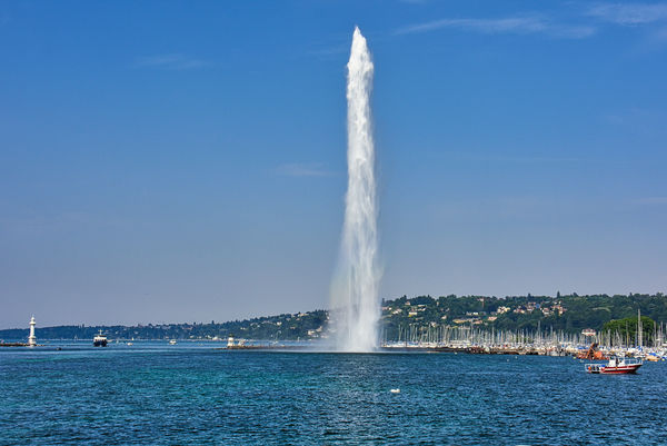
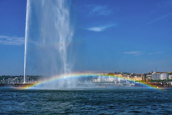
THE JET D'EAU(French pronunciation: [ʒɛ do], Water-Jet) is a large fountain in Geneva, Switzerland and is one of the city's most famous landmarks, being featured on the city's official tourism web site and on the official logo for Geneva's hosting of group stage matches in the 2008 UEFA Euro. Situated where Lake Geneva exits as the Rhône, it is visible throughout the city and from the air, even when flying over Geneva at an altitude of 10 kilometres (33,000 ft).
Five hundred litres (110 imp gal; 130 US gal) of water per second are jetted to an altitude of 140 metres (460 ft) by two 500 kW pumps, operating at 2,400 V, consuming one megawatt of electricity.[2][3][4] The water leaves the 10 centimetres (3.9 in) nozzle at a speed of 200 kilometres per hour (120 mph). At any given moment, there are about 7,000 litres (1,500 imp gal; 1,800 US gal) of water in the air. Unsuspecting visitors to the fountain—which can be reached via a stone jetty from the left bank of the lake—may be surprised to find themselves drenched after a slight change in wind direction.
The first Jet d'Eau was installed in 1886 at the Usine de la Coulouvrenière, a little further downstream from its present location. It was used as a safety valve for a hydraulic power network and could reach a height of about 30 metres (98 ft). In 1891, its aesthetic value was recognised and it was moved to its present location to celebrate the Federal Gymnastics Festival and the 600th anniversary of the Swiss Confederation, when it was operated for the first time. Its maximum height was about 90 metres (295 feet). The present Jet d'Eau was installed in 1951 in a partially submerged pumping station to pump lake water instead of city water.
Since 2003, the fountain has operated during the day all year round, except in case of frost or particularly strong wind. It also operates in the evenings between spring and autumn, when it is lit by a set of 21 lights totaling 9 kW. On 25 August 2016, the fountain celebrated its 125th anniversary at its present location.
https://en.wikipedia.org/wiki/Jet_d%27Eau
I hope you enjoy these. For more about Geneva and additional images, please see my previous post: https://www.uglyhedgehog.com/t-701071-1.html
Mark
Lake Geneva (French: le Léman [lə lemɑ̃] (rarely lac de Genève [lak də ʒ(ə)nɛv], lac Léman [lak lemɑ̃]); Italian: Lago Lemano; German: Genfersee [ˈɡɛnfərˌzeː]; Romansh: Lai da Genevra) is a deep lake on the north side of the Alps, shared between Switzerland and France. It is one of the largest lakes in Western Europe and the largest on the course of the Rhône. Sixty per cent (345.31 km2 or 133.32 sq mi) of the lake belongs to Switzerland (the cantons of Vaud, Geneva, and Valais), and forty per cent (234.71 km2 or 90.62 sq mi) to France (the department of Haute-Savoie).
While the exact origins of the name are unknown, the name Lacus Lemanus was in use during the time of Julius Caesar. Lemannus comes from Ancient Greek Liménos Límnē (Λιμένος Λίμνη) meaning "port's lake"; it became Lacus Lausonius, although this name was also used for a town or district on the lake, Lacus Losanetes, and then the Lac de Lausanne in the Middle Ages. Following the rise of Geneva it became Lac de Genève[5] (translated into English as Lake Geneva), but Le Léman was the common name on all local maps and is the customary name in the French language. In contemporary English, the name Lake Geneva has become predominant.
Lake Geneva is divided into three parts because of its different types of formation (sedimentation, tectonic folding, glacial erosion):
Haut Lac (Upper Lake), the eastern part from the Rhône estuary to the line of Meillerie–Rivaz
Grand Lac (Large Lake), the largest and deepest basin with the lake's largest width
Petit Lac (Small Lake), the most south-west, narrower and less deep part from Yvoire–Promenthoux next Prangins to the exit in Geneva
According to the Swiss Federal Office of Topography, Swisstopo, Lac de Genève designates that part of the Petit Lac, which lies within the cantonal borders of Geneva (excluding the cantonal exclave Céligny), so about from Versoix–Hermance to the Rhône outflow in Geneva.
The Chablais Alps border is its southern shore, the western Bernese Alps lie over its eastern side. The high summits of Grand Combin and Mont Blanc are visible from some places. Compagnie Générale de Navigation sur le lac Léman (CGN) operates boats on the lake.
The lake lies on the course of the Rhône. The river has its source at the Rhône Glacier near the Grimsel Pass to the east of the lake and flows down through the canton of Valais, entering the lake between Villeneuve and Le Bouveret, before flowing slowly towards its egress at Geneva. Other tributaries are La Dranse, L'Aubonne, La Morges, La Venoge, La Vuachère, and La Veveyse.
Lake Geneva is the largest body of water in Switzerland, and greatly exceeds in size all others that are connected with the main valleys of the Alps. It is in the shape of a crescent, with the horns pointing south, the northern shore being 95 km (59 mi), the southern shore 72 km (45 mi) in length. The crescent form was more regular in a recent geological period, when the lake extended to Bex, about 18 km (11 mi) south of Villeneuve. The detritus of the Rhône has filled up this portion of the bed of the lake, and it appears that within the historical period the waters extended about 2 km (1.2 mi) beyond the present eastern margin of the lake. The greatest depth of the lake, in the broad portion between Évian-les-Bains and Lausanne, where it is just 13 km (8.1 mi) in width, has been measured as 310 m (1,020 ft), putting the bottom of the lake at 62 m (203 ft) above sea level. The lake's surface is the lowest point of the cantons of Valais and Vaud. The culminating point of the lake's drainage basin is Monte Rosa at 4,634 metres above sea level.
The beauty of the shores of the lake and of the sites of many of the places near its banks has long been celebrated. However, it is only from the eastern end of the lake, between Vevey and Villeneuve, that the scenery assumes an Alpine character. On the south side the mountains of Savoy and Valais are for the most part rugged and sombre, while those of the northern shore fall in gentle vine-covered slopes, thickly set with villages and castles.[7]
The snowy peaks of the Mont Blanc are shut out from the western end of the lake by the Voirons mountain, and from its eastern end by the bolder summits of the Grammont, Cornettes de Bise and Dent d'Oche, but are seen from Geneva, and between Nyon and Morges. From Vevey to Bex, where the lake originally extended, the shores are enclosed by comparatively high and bold mountains, and the vista terminates in the grand portal of the defile of St. Maurice, cleft to a depth of nearly 2,700 m (8,900 ft) between the opposite peaks of the Dents du Midi and the Dent de Morcles.
The shore between Nyon and Lausanne is called La Côte because it is flatter. Between Lausanne and Vevey it is called Lavaux and is famous for its hilly vineyards.
The average surface elevation of 372 m (1,220 ft) above sea level is controlled by the Seujet Dam [fr] in Geneva.
https://en.wikipedia.org/wiki/Lake_Geneva
THE JET D'EAU(French pronunciation: [ʒɛ do], Water-Jet) is a large fountain in Geneva, Switzerland and is one of the city's most famous landmarks, being featured on the city's official tourism web site and on the official logo for Geneva's hosting of group stage matches in the 2008 UEFA Euro. Situated where Lake Geneva exits as the Rhône, it is visible throughout the city and from the air, even when flying over Geneva at an altitude of 10 kilometres (33,000 ft).
Five hundred litres (110 imp gal; 130 US gal) of water per second are jetted to an altitude of 140 metres (460 ft) by two 500 kW pumps, operating at 2,400 V, consuming one megawatt of electricity.[2][3][4] The water leaves the 10 centimetres (3.9 in) nozzle at a speed of 200 kilometres per hour (120 mph). At any given moment, there are about 7,000 litres (1,500 imp gal; 1,800 US gal) of water in the air. Unsuspecting visitors to the fountain—which can be reached via a stone jetty from the left bank of the lake—may be surprised to find themselves drenched after a slight change in wind direction.
The first Jet d'Eau was installed in 1886 at the Usine de la Coulouvrenière, a little further downstream from its present location. It was used as a safety valve for a hydraulic power network and could reach a height of about 30 metres (98 ft). In 1891, its aesthetic value was recognised and it was moved to its present location to celebrate the Federal Gymnastics Festival and the 600th anniversary of the Swiss Confederation, when it was operated for the first time. Its maximum height was about 90 metres (295 feet). The present Jet d'Eau was installed in 1951 in a partially submerged pumping station to pump lake water instead of city water.
Since 2003, the fountain has operated during the day all year round, except in case of frost or particularly strong wind. It also operates in the evenings between spring and autumn, when it is lit by a set of 21 lights totaling 9 kW. On 25 August 2016, the fountain celebrated its 125th anniversary at its present location.
https://en.wikipedia.org/wiki/Jet_d%27Eau
I hope you enjoy these. For more about Geneva and additional images, please see my previous post: https://www.uglyhedgehog.com/t-701071-1.html
Mark
(Download)
(Download)
(Download)
(Download)
(Download)

(Download)

(Download)
(Download)

(Download)
(Download)
Jun 18, 2021 17:21:00 #

Jun 18, 2021 17:24:41 #
Jun 18, 2021 17:27:48 #
Fotoartist wrote:
Eye-popping colors! Appreciate the map.
Thanks so much Fotoartist. It really is a colorful city. More to come.
Jun 18, 2021 18:11:03 #

Jun 18, 2021 18:38:59 #

Jun 18, 2021 18:40:09 #

Jun 18, 2021 19:21:49 #
srfmhg wrote:
We crossed beautiful Lake Geneva by boat and visit... (show quote)
Another beautiful set Mark, along with informative narrative. BTW, those two pumps at 500 KW each total 1,340 horsepower (746W = 1 HP).
Jun 18, 2021 20:56:16 #
newsguygeorge wrote:
Love the sailboats with the spinnakers. Reminds me of my youth.
Thanks George. They were quite impressive and raced every day.
Jun 18, 2021 20:56:38 #
UTMike wrote:
You know that I like water, Mark, well done!
Thanks so much Mike.
Jun 18, 2021 20:57:10 #
Jun 18, 2021 21:01:23 #
DJphoto wrote:
Another beautiful set Mark, along with informative narrative. BTW, those two pumps at 500 KW each total 1,340 horsepower (746W = 1 HP).
Thanks so much Dennis and thanks for the conversion to HP.
Jun 18, 2021 21:45:54 #
Outstanding, Mark. I visited there when I was in the Army and stationed in Germany.
Jun 18, 2021 23:52:20 #
srfmhg wrote:
We crossed beautiful Lake Geneva by boat and visit... (show quote)
Wonderful work ...the accompaniment of the monologue is fantastic .....
Jun 19, 2021 00:56:37 #
shangyrhee
Loc: Nashville TN to Sacramento CA
Wow, another gorgeous series !!! Thank you, Mark. Shang
If you want to reply, then register here. Registration is free and your account is created instantly, so you can post right away.