Switzerland: Cruising To Gandria On Lake Lugano
May 26, 2021 15:30:55 #

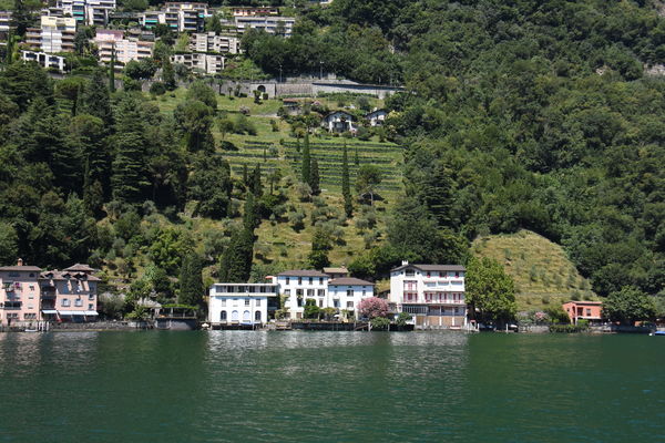
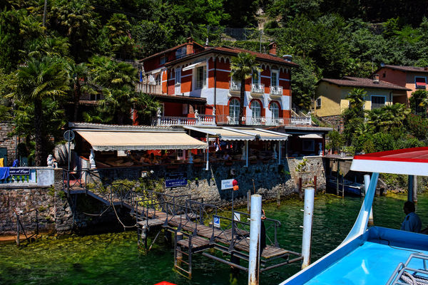
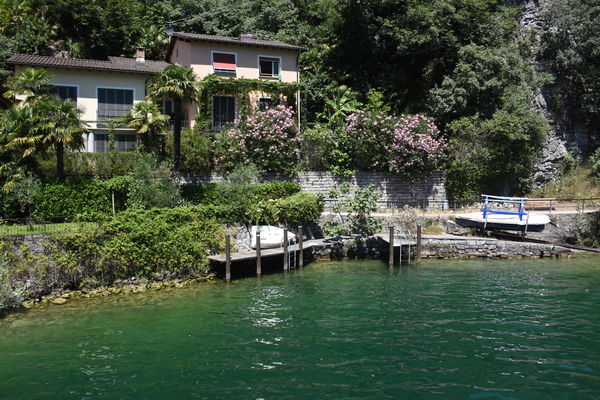
One of the highlights of our stay in Lugano was a cruise on Lake Lugano on one of the many passenger boats to the small lakeshore town of Gandria for lunch.
Lake Lugano (Italian: Lago di Lugano or Ceresio, from Latin: Ceresius lacus; Lombard: Lagh de Lugan; German: About this soundLuganersee) is a glacial lake which is situated on the border between southern Switzerland and northern Italy. The lake, named after the city of Lugano, is situated between Lake Como and Lago Maggiore. It was cited for the first time by Gregory of Tours in 590 with the name Ceresio, a name which is said to have derived from the Latin word cerasus, meaning cherry, and refers to the abundance of cherry trees which at one time adorned the shores of the lake. The lake appears in documents in 804 under the name Laco Luanasco.
There are various mountains and tourist destinations on the shores of the lake including Monte Brè to the east, Monte San Salvatore west of Lugano, and Monte Generoso on the south-eastern shore. The World Heritage Site Monte San Giorgio is situated south of the lake. Also located to the south is the Cinque Vette Park. The lake is drained by the Tresa, which empties into Lake Maggiore, the latter being drained by the Ticino and the Po.
The first certain testimony of a political body governing the shores of the lake is from 818. Occupying an area of strategic importance, the lake was then part of the feudal dominion of the County of Sperio. Circa 1000, it came under the control of the Bishop of Como. The region was the site of the war between Como and Milan over control of Alpine traffic from 1218 to 1227. As the lake and its shores became progressively incorporated into the Duchy of Milan they became the subject of political and territorial contention during the 15th century, and Lugano became the lake's main town.
The lake definitively ceased to belong to a single sovereign political entity following the establishment of the transalpine bailiwicks of the Swiss cantons at the beginning of the 16th century. The Italian-Swiss border was fixed in 1752 by the Treaty of Varese, and has since remained virtually unchanged.
In 1848, the Melide causeway was built on a moraine between Melide and Bissone, in order to carry a road across the lake and provide a direct connection between Lugano and Chiasso. Today the causeway also carries the Gotthard railway and the A2 motorway.
The lake is 48.7 km2 (18.8 sq mi) in size, 63% of which is in Switzerland and 37% in Italy, has an average width of roughly 1 km (0.62 mi), a maximum depth of 288 m (945 ft) found in the northern basin. The culminating point of the lake's drainage basin is the Pizzo di Gino summit in the Lugano Prealps (2,245 m, 7,365 ft).[3] Bathing in the lake is allowed at any of the 50 or so bathing establishments located along the Swiss shores.
The lake is navigable, and used by a considerable number of private vessels. Passenger boats of the Società Navigazione del Lago di Lugano (SNL) provide services on the lake, principally for tourist purposes, but also connecting Lugano with other lakeside communities, some of which have no road access. Fishery in the lake (and Lake Maggiore) is regulated by a 1986 agreement between Switzerland and Italy. The current agreement on navigation dates from 1992.
https://en.wikipedia.org/wiki/Lake_Lugano
I hope you enjoy these images. Please try the downloads for color and clarity.
Mark

(Download)

(Download)

(Download)

(Download)
(Download)

(Download)

(Download)
A stop at one of the small villages along the lakeshore
(Download)
Not a bad place to live
(Download)

(Download)
May 26, 2021 15:38:33 #


May 26, 2021 15:54:48 #

May 26, 2021 16:09:18 #
May 26, 2021 16:15:36 #
srfmhg wrote:
One of the highlights of our stay in Lugano was a ... (show quote)
Beautiful photos of a beautiful place Mark. We'll be "one lake over" at Lake Como for 3 days in about a year and can't wait.
May 26, 2021 16:20:15 #

May 26, 2021 17:51:14 #
May 26, 2021 17:51:37 #
May 26, 2021 17:52:02 #
Vince68 wrote:
Very nice set Mark. Beautiful scenery.
Thanks very much Vince.
May 26, 2021 17:53:17 #
DJphoto wrote:
Beautiful photos of a beautiful place Mark. We'll be "one lake over" at Lake Como for 3 days in about a year and can't wait.
Thanks so much for your comments Dennis. I will post a few sets from Lake Como soon.
May 26, 2021 17:53:42 #
May 26, 2021 18:23:12 #
May 26, 2021 18:25:08 #
kpmac wrote:
Excellent, Mark. You captured the beauty of the place so well.
Thanks so much Ken. I appreciate your saying that!
May 26, 2021 19:19:02 #

Fabulous set, Mark. The downloads are beautiful. It was great that you got some shots from the boat, I love #6. Thanks for the history also.
May 26, 2021 19:27:08 #
joehel2 wrote:
Fabulous set, Mark. The downloads are beautiful. It was great that you got some shots from the boat, I love #6. Thanks for the history also.
Thanks so much Joe. The scenery from the boat was awesome and I'll post more. My wife did get a few of me in action.

If you want to reply, then register here. Registration is free and your account is created instantly, so you can post right away.