Switzerland: Jungfrau Region
Feb 9, 2021 17:52:16 #

The Jungfrau (transl. "maiden, virgin"), at 4,158 meters (13,642 ft) is one of the main summits of the Bernese Alps, located between the northern canton of Bern and the southern canton of Valais, halfway between Interlaken and Fiesch. Together with the Eiger and Mönch, the Jungfrau forms a massive wall of mountains overlooking the Bernese Oberland and the Swiss Plateau, one of the most distinctive sights of the Swiss Alps.
The summit was first reached on August 3, 1811, by the Meyer brothers of Aarau and two chamois hunters from Valais. The ascent followed a long expedition over the glaciers and high passes of the Bernese Alps. It was not until 1865 that a more direct route on the northern side was opened.
The construction of the Jungfrau railway in the early 20th century, which connects Kleine Scheidegg to the Jungfraujoch, the saddle between the Mönch and the Jungfrau, made the area one of the most-visited places in the Alps. Along with the Aletsch Glacier to the south, the Jungfrau is part of the Jungfrau-Aletsch area, which was declared a World Heritage Site in 2001.
The name Jungfrau ("maiden, virgin"), which refers to the highest of the three prominent mountains overlooking the Interlaken region, along with the Mönch ("monk") and the Eiger ("ogre"), is most likely derived from the name Jungfrauenberg given to Wengernalp, the alpine meadow directly facing the huge northern side of the Jungfrau, across the Trummelbach gorge. Wengernalp was so named for the nuns of Interlaken Monastery, its historical owner. Contrary to popular belief, the name did not originate from the appearance of the snow-covered mountain, the latter looking like a veiled woman.
The "virgin" peak was heavily romanticized as "goddess" or "priestess" in late 18th to 19th century Romanticism. Its summit, considered inaccessible, remained untouched until the 19th century. After the first ascent in 1811 by Swiss alpinist Johann Rudolf Meyer, the peak was jokingly referred to as "Mme Meyer" (Mrs. Meyer).
Politically, the Jungfrau (and its massif) is split between the municipalities of Lauterbrunnen (Bern) and Fieschertal (Valais). It is the third-highest mountain of the Bernese Alps after the nearby Finsteraarhorn and Aletschhorn, respectively 12 and 8 km (7.5 and 5 mi) away. But from Lake Thun, and the greater part of the canton of Bern, it is the most conspicuous and the nearest of the Bernese Oberland peaks; with a height difference of 3,600 m (11,800 ft) between the summit and the town of Interlaken. This, and the extreme steepness of the north face, secured for it an early reputation for inaccessibility.
The Jungfrau is the westernmost and highest point of a gigantic 10 km (6.2 mi) wall dominating the valleys of Lauterbrunnen and Grindelwald. The wall is formed by the alignment of some of the biggest north faces in the Alps, with the Mönch (4,107 m or 13,474 ft) and Eiger (3,967 m or 13,015 ft) to the east of the Jungfrau, and overlooks the valleys to its north by a height of up to 3 km (1.9 mi). The Jungfrau is approximately 6 km (3.7 mi) from the Eiger; with the summit of the Mönch between the two mountains, 3.5 km (2.2 mi) from the Jungfrau. The Jungfraujoch is the saddle between the Jungfrau and the Mönch and the Eigerjoch is the saddle between the Mönch and the Eiger. The wall is extended to the east by the Fiescherwand and to the west by the Lauterbrunnen Wall, although it follows different directions from the Jungfrau and the Eiger.
The difference of altitude between the deep valley of Lauterbrunnen (800 m or 2,600 ft) and the summit is particularly visible from the area of Mürren. From the valley floor, west of the massif, the altitude gain is more than 3 km (1.9 mi) for a horizontal distance of 4 km (2.5 mi). The landscapes around the Jungfrau are extremely contrasted. In contrast to the vertiginous precipices of its northwest, the mountain's southeastern side emerges from the upper snows of the Aletsch Glacier at around 3,500 meters (11,500 ft). The 20-kilometer-long (12 mi) valley of Aletsch on the southeast is completely uninhabited, and is surrounded by neighboring valleys with similar landscapes. The area as a whole constitutes the largest glaciated area not just in the Alps, but also well as in Europe.
While the mountain peak was once difficult to access, the Jungfraubahn cog railway now goes to the Jungfraujoch railway station at 3,454 m (11,332 ft), the highest in Europe. The Jungfraujoch is the lowest pass between the Jungfrau and Mönch. In 1893, Adolf Guyer-Zeller conceived of the idea of a railway tunnel to the Jungfraujoch to make the glaciated areas on its south side more accessible. The building of the tunnel took 16 years and the summit station was not opened before 1912. The goal was in fact to reach the summit of the Jungfrau with an elevator from the highest railway station, located inside the mountain. The complete project was not realized because of the outbreak of the World War I.
The train into the mountain leaves from Kleine Scheidegg, which can be reached by trains from Grindelwald and Lauterbrunnen via Wengen. The train enters the tunnel running eastward through the Eiger shortly above Kleine Scheidegg. Before arriving at the Jungfraujoch, it stops for a few minutes at two other stations, Eigerwand (on the north face of the Eiger) and Eismeer (on the south side), where passengers can see through the holes excavated from the mountain. The journey from Kleine Scheidegg to Jungfraujoch takes approximately 50 minutes including the stops; the downhill return journey taking only 35 minutes.
A large complex of tunnels and buildings has been constructed at the Jungfraujoch, mostly into the south side of the Mönch. There is a hotel, two restaurants, an observatory, a research station, a small cinema, a ski school, and the "Ice Palace", a collection of elaborate ice sculptures. Another tunnel leads outside to a flat, snow-covered area, where one can walk around and look down to the Konkordiaplatz and the Aletsch Glacier, as well as the surrounding mountains.
Apart from the Jungfraujoch, many facilities have been built in the two valleys north of the Jungfrau (the commonly named Jungfrau Region), including numerous mountain railways. In 1908, the first public cable car in the world opened at the foot of the Wetterhorn, but was closed seven years later. The Schilthorn above Mürren or the Männlichen above Wengen offer good views of the Jungfrau and other summits.
https://en.wikipedia.org/wiki/Jungfrau
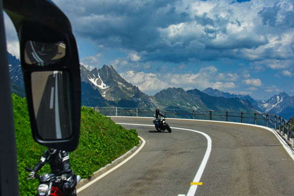
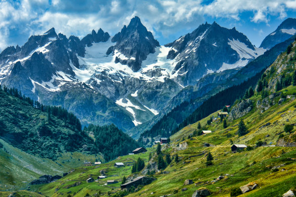
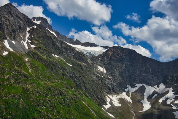
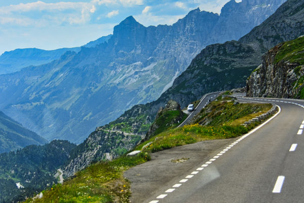
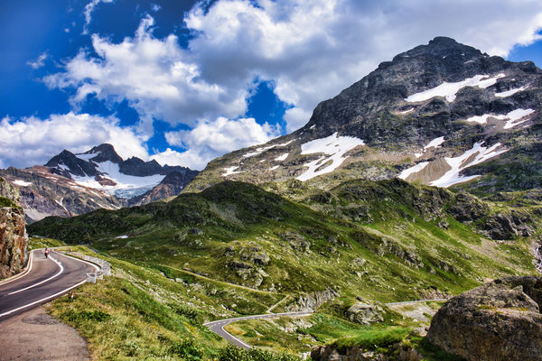
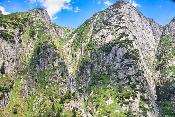
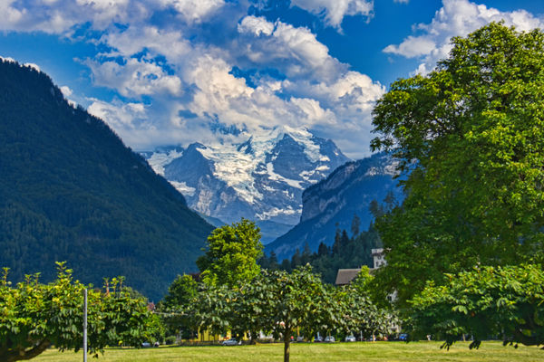
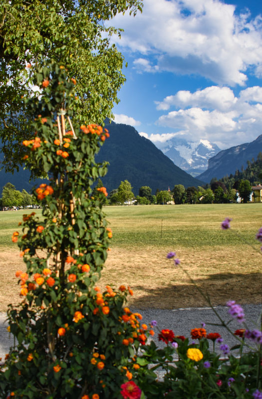
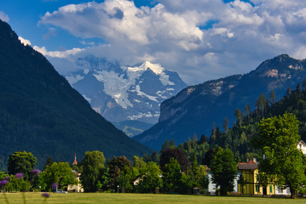
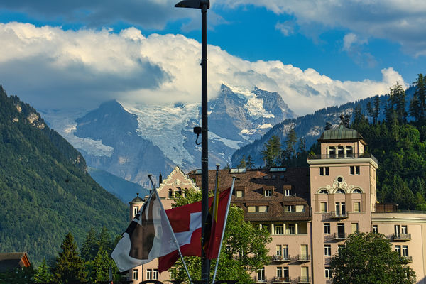
Our drive through the Alps to Interlaken, our base for exploring the region, was breathtaking. Images 1-6 were taken through the tour bus window with a Nikon D7200 and a Nikkor 18-300 lens at f8, 1/400m sec. auto ISO. Images 7-10 were taken from in front of our hotel, The Victoria, in Interlaken. I hope you enjoy them.
Mark
The summit was first reached on August 3, 1811, by the Meyer brothers of Aarau and two chamois hunters from Valais. The ascent followed a long expedition over the glaciers and high passes of the Bernese Alps. It was not until 1865 that a more direct route on the northern side was opened.
The construction of the Jungfrau railway in the early 20th century, which connects Kleine Scheidegg to the Jungfraujoch, the saddle between the Mönch and the Jungfrau, made the area one of the most-visited places in the Alps. Along with the Aletsch Glacier to the south, the Jungfrau is part of the Jungfrau-Aletsch area, which was declared a World Heritage Site in 2001.
The name Jungfrau ("maiden, virgin"), which refers to the highest of the three prominent mountains overlooking the Interlaken region, along with the Mönch ("monk") and the Eiger ("ogre"), is most likely derived from the name Jungfrauenberg given to Wengernalp, the alpine meadow directly facing the huge northern side of the Jungfrau, across the Trummelbach gorge. Wengernalp was so named for the nuns of Interlaken Monastery, its historical owner. Contrary to popular belief, the name did not originate from the appearance of the snow-covered mountain, the latter looking like a veiled woman.
The "virgin" peak was heavily romanticized as "goddess" or "priestess" in late 18th to 19th century Romanticism. Its summit, considered inaccessible, remained untouched until the 19th century. After the first ascent in 1811 by Swiss alpinist Johann Rudolf Meyer, the peak was jokingly referred to as "Mme Meyer" (Mrs. Meyer).
Politically, the Jungfrau (and its massif) is split between the municipalities of Lauterbrunnen (Bern) and Fieschertal (Valais). It is the third-highest mountain of the Bernese Alps after the nearby Finsteraarhorn and Aletschhorn, respectively 12 and 8 km (7.5 and 5 mi) away. But from Lake Thun, and the greater part of the canton of Bern, it is the most conspicuous and the nearest of the Bernese Oberland peaks; with a height difference of 3,600 m (11,800 ft) between the summit and the town of Interlaken. This, and the extreme steepness of the north face, secured for it an early reputation for inaccessibility.
The Jungfrau is the westernmost and highest point of a gigantic 10 km (6.2 mi) wall dominating the valleys of Lauterbrunnen and Grindelwald. The wall is formed by the alignment of some of the biggest north faces in the Alps, with the Mönch (4,107 m or 13,474 ft) and Eiger (3,967 m or 13,015 ft) to the east of the Jungfrau, and overlooks the valleys to its north by a height of up to 3 km (1.9 mi). The Jungfrau is approximately 6 km (3.7 mi) from the Eiger; with the summit of the Mönch between the two mountains, 3.5 km (2.2 mi) from the Jungfrau. The Jungfraujoch is the saddle between the Jungfrau and the Mönch and the Eigerjoch is the saddle between the Mönch and the Eiger. The wall is extended to the east by the Fiescherwand and to the west by the Lauterbrunnen Wall, although it follows different directions from the Jungfrau and the Eiger.
The difference of altitude between the deep valley of Lauterbrunnen (800 m or 2,600 ft) and the summit is particularly visible from the area of Mürren. From the valley floor, west of the massif, the altitude gain is more than 3 km (1.9 mi) for a horizontal distance of 4 km (2.5 mi). The landscapes around the Jungfrau are extremely contrasted. In contrast to the vertiginous precipices of its northwest, the mountain's southeastern side emerges from the upper snows of the Aletsch Glacier at around 3,500 meters (11,500 ft). The 20-kilometer-long (12 mi) valley of Aletsch on the southeast is completely uninhabited, and is surrounded by neighboring valleys with similar landscapes. The area as a whole constitutes the largest glaciated area not just in the Alps, but also well as in Europe.
While the mountain peak was once difficult to access, the Jungfraubahn cog railway now goes to the Jungfraujoch railway station at 3,454 m (11,332 ft), the highest in Europe. The Jungfraujoch is the lowest pass between the Jungfrau and Mönch. In 1893, Adolf Guyer-Zeller conceived of the idea of a railway tunnel to the Jungfraujoch to make the glaciated areas on its south side more accessible. The building of the tunnel took 16 years and the summit station was not opened before 1912. The goal was in fact to reach the summit of the Jungfrau with an elevator from the highest railway station, located inside the mountain. The complete project was not realized because of the outbreak of the World War I.
The train into the mountain leaves from Kleine Scheidegg, which can be reached by trains from Grindelwald and Lauterbrunnen via Wengen. The train enters the tunnel running eastward through the Eiger shortly above Kleine Scheidegg. Before arriving at the Jungfraujoch, it stops for a few minutes at two other stations, Eigerwand (on the north face of the Eiger) and Eismeer (on the south side), where passengers can see through the holes excavated from the mountain. The journey from Kleine Scheidegg to Jungfraujoch takes approximately 50 minutes including the stops; the downhill return journey taking only 35 minutes.
A large complex of tunnels and buildings has been constructed at the Jungfraujoch, mostly into the south side of the Mönch. There is a hotel, two restaurants, an observatory, a research station, a small cinema, a ski school, and the "Ice Palace", a collection of elaborate ice sculptures. Another tunnel leads outside to a flat, snow-covered area, where one can walk around and look down to the Konkordiaplatz and the Aletsch Glacier, as well as the surrounding mountains.
Apart from the Jungfraujoch, many facilities have been built in the two valleys north of the Jungfrau (the commonly named Jungfrau Region), including numerous mountain railways. In 1908, the first public cable car in the world opened at the foot of the Wetterhorn, but was closed seven years later. The Schilthorn above Mürren or the Männlichen above Wengen offer good views of the Jungfrau and other summits.
https://en.wikipedia.org/wiki/Jungfrau
Our drive through the Alps to Interlaken, our base for exploring the region, was breathtaking. Images 1-6 were taken through the tour bus window with a Nikon D7200 and a Nikkor 18-300 lens at f8, 1/400m sec. auto ISO. Images 7-10 were taken from in front of our hotel, The Victoria, in Interlaken. I hope you enjoy them.
Mark
(Download)
(Download)
(Download)
(Download)
(Download)
(Download)
Jungfraujoch in the background
(Download)
(Download)
(Download)
(Download)
Feb 9, 2021 17:58:13 #
Feb 9, 2021 18:02:56 #

Feb 9, 2021 18:08:15 #
Susan yamakawa wrote:
Loved the contrast of flowers and the mountains 👍👍😊😊
Spectacular and well photographed Mark!

Feb 9, 2021 18:41:34 #
Feb 9, 2021 18:56:20 #
domcomm
Loc: Denver, CO
Wow! Gorgeous shots! Does that ever bring back memories! I used to work for a large publishing company, and they sent me on a 3-month trip around the world, which included Switzerland. I took 15,000 pictures on that trip. When I tried to get a good shot of Jungfrau Falls, I parked and walked across the road, then over a little 2-board bridge into a field to get the angle I wanted. On the way back over the bridge, one of the boards broke, and I went straight down into the little stream. I was able to get the film out safely, so I got the pictures, but it destroyed my Hassleblad.
Feb 9, 2021 18:57:18 #
Susan yamakawa wrote:
Loved the contrast of flowers and the mountains 👍👍😊😊
Thanks very much Susan.
Feb 9, 2021 18:57:42 #
Feb 9, 2021 18:58:22 #
DJphoto wrote:
Spectacular and well photographed Mark!
Thanks so much Dennis. I always appreciate your generous comments.
Feb 9, 2021 18:58:59 #
Ourspolair wrote:
Another great travelogue! Thanks for sharing. Please stay safe.
Thanks so much for following and for your kind comments George.
Feb 9, 2021 19:00:49 #
domcomm wrote:
Wow! Gorgeous shots! Does that ever bring back mem... (show quote)
Sad story and too bad about the classic camera Dom. Thanks so much for commenting.
Feb 9, 2021 19:46:09 #

Feb 9, 2021 20:03:39 #
Beautiful, Mark. A place I actually have visited. I only have some faded photos of my time there, unfortunately.
Feb 9, 2021 22:24:49 #
UTMike wrote:
A gorgeous set, Mark! I have only seen the area during ski season.
Thanks so much Mike. I’m sure it has a whole other beauty in Winter.
Feb 9, 2021 22:27:33 #
kpmac wrote:
Beautiful, Mark. A place I actually have visited. I only have some faded photos of my time there, unfortunately.
Thanks very much Ken. Hopefully these will refresh your memory. I was going over the entire Switzerland folder today and realized that there were several good shots that I haven’t posted so you’ll see more over the next few weeks.
If you want to reply, then register here. Registration is free and your account is created instantly, so you can post right away.