Change topo lines in map photo with Photoshop
Dec 30, 2020 18:36:35 #
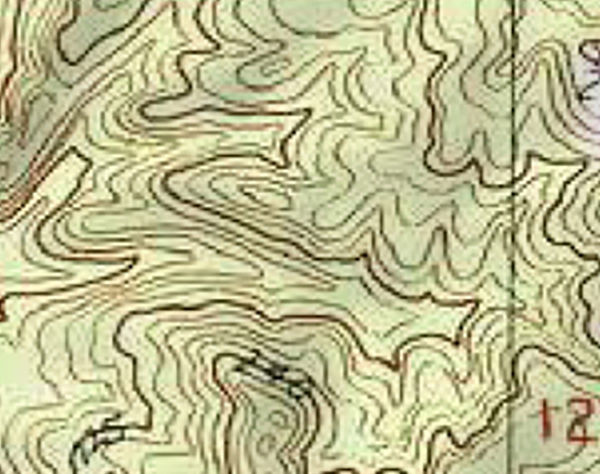
I have a digital image of topo map that is being used at a big increase in size causing the topo lines to be fuzzy. I would like to be able to fix them in Photoshop so that they look more like an in focus line. The attached sample image is 7.493 inches wide and 5.917 inches tall and 300 pixels/inch. That is the size I want when it is printed out on paper. Also, because the map is enlarged so much, I would like to have the topo lines be thinner and more sharp.
I am thinking that I can open a new layer and trace the lines onto the new layer with the brush tool. I would like the line to be in the 10-15 pixel width. I could use the clone stamp tool to block out the existing lines on the background of the map so the existing lines would not be visible.
The thing about doing it this way is that tracing all those lines will take a lot of time and it would be difficult to accurately trace the lines. Also, clone stamping the existing lines out would take a lot of cloning. Does anyone have an easier way to accomplish my task?
Dec 30, 2020 19:02:13 #
Dec 30, 2020 21:52:57 #

I'll say right from the start that I can't help you with Photoshop, but I have done exactly what you want to do.
However, I had the luxury of doing it in AutoCad with the Civil Engineering add-on. I imported a jpg scan of a topo map into a blank AutoCad file and traced the lines of the scan. I then turned the traced contours into polylines which allowed me to smooth them and assign an elevation to each line.
I imagine it would be a more tedious exercise in Photoshop....good luck.
Dec 31, 2020 06:07:17 #

Don't really see what you want to acheive, but if I were trying to do that here (U.K.) I'd just go to the map publishers page and buy a copy in the scale I want for the area I want.
Dec 31, 2020 07:24:05 #
A lot of maps are available online in GIS databases. They should be scalable to the size you want.
Dec 31, 2020 07:45:31 #
Powergroove75
Loc: Coeur d'Alene, ID
Find a larger resolution picture of the map. Easiest option. Or.... Take a photo of one yourself.
Making pixels unpixelate is pretty much impossible.
Making pixels unpixelate is pretty much impossible.
Dec 31, 2020 08:31:51 #
pnorman4345
Loc: Massachustts
Adobe Illustrator has a tool to convert a file to vector graphics which is what you need. It may not work well for your file.
Dec 31, 2020 11:14:50 #
I would access the US geological survey's online database of scanned Topo quads, basically everything in the country is available at the seven and a half minute to 15 minutes scale. Download a new jpeg from that site, and crop out what you need. I do this frequently for college-level exercises for students, especially these days!
Jan 1, 2021 16:39:20 #
Geologist here. If you get the USGS maps, the contour lines don't get thinner when you enlarge the image. I often include re-drafted topo maps from an enlarged original in my consulting reports. I enlarge the scanned original to the proper scale, then print it out. Put a sheet of single-sided, frosted Mylar on top (translucent) and trace the middle of the contour line by hand using Micron PN (dense, India ink) pens. These come in a variety of thicknesses for the index and intermediate contours. Then scan the Mylar and make any corrections or additions of text or elevation values in Photoshop (actually, I use PowerPoint for most of my technical drafting). I find hand drawing the contours to be much quicker and the contours smoother than trying to do the whole thing in Photoshop. Pens and Mylar are available at any good art supply store. Good luck.
Jan 1, 2021 17:20:09 #
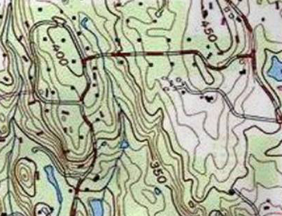
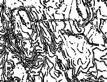
I downloaded a topo map and played around with it. I made the image into a layer and added an empty layer on top. I then went to the topo layer and did a Select -> Color Range on one of the lines. The selection depends on the "fuzziness" which is the range of colors that it will use for the selection. You have to play around with that to get selected lines without too many breaks. You then switch from Layer to Path and make the selection into a path. Using the pencil with a fairly narrow point (1 pixel was too small, 2 pixels was not too bad, 3 pixels was probably too large) I then switched to the empty layer and stroked the path. That gave me lines along the selection.
The problem is that the color of the topo lines is somewhat variable and other lines on the map use similar colors so the topo lines are mixed with roads and streams and other map marks. Note from the images below that not only are there breaks in the topo lines, the roads complicate the image and make it hard to follow the topo lines.
I did not find this to be a viable technique without a lot of handwork.
I did a quick search for GIS databases and could not find anything near this location that I could download easily.
.
Topo image
Topo image with stroked paths

Stroked paths without underlying image
Jan 1, 2021 19:36:13 #
dat2ra wrote:
Geologist here. If you get the USGS maps, the cont... (show quote)
I didn't think of tracing the lines by hand on a sheet and then scanning the sheet. It certainly would be much easier than tracing the lines in Photoshop. You are correct that the topo lines don't stay thin when enlarging the map. The other suggestions of using the USGS maps were not helpful because I was using an image that was greater in size than the available USGS maps, and that is what I was starting from.
Can you get the frosted Mylar and Micron PN pens at Staples or Office Max or Hobby Lobby? I am not familiar with them.
I'm thinking that using the Healing brush might be better than using the Clone Stamp tool to remove the topo lines from the map background.
Jan 5, 2021 21:18:16 #
I'm don't know if Office Max or Hobby Lobby carry art supplies but I would think they would (in the "Drafting" section); all Art Supply stores have these items, though. The "tracing" method is particularly handy if the area you need falls on more than one quadrangle because often the colors of the contours and "vegetation" are not uniform so direct scanning is not optimal.
If you want to reply, then register here. Registration is free and your account is created instantly, so you can post right away.