Into the Midnight Sun: Through the Thames Barrier at night
Sep 30, 2020 17:50:15 #

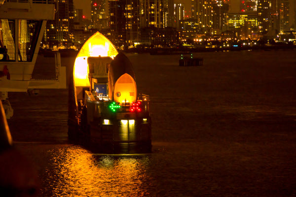
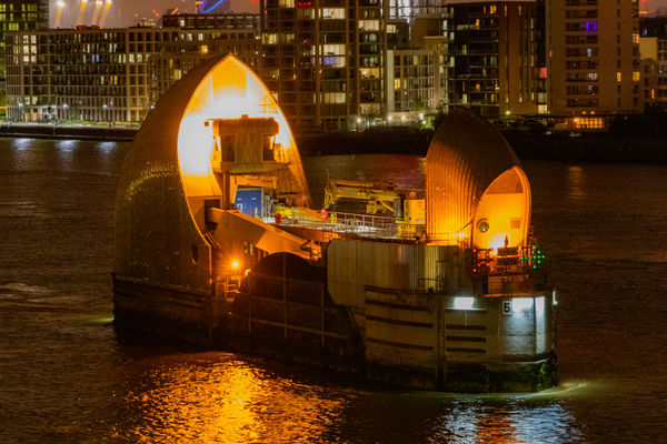
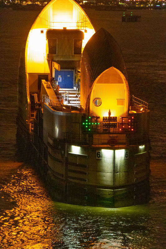
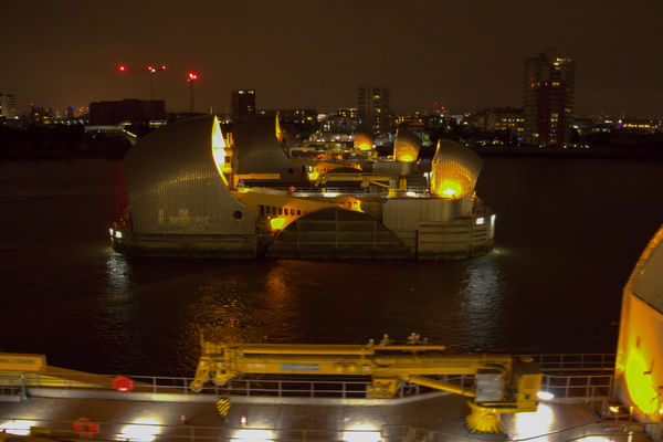
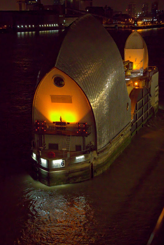
This is the third of four parts of this series; the second part can be found at https://www.uglyhedgehog.com/t-667656-1.html We were cruising up the River Thames from Edinburgh to Greenwich (London) on the Viking Star. The first two photos were taken at ISO 5000, the remainder at 6400 as we approached and cruised through the Thames Barrier. These photos were taken between 11:48 PM and 11:59 PM. The following information is from Wikipedia.
The Thames Barrier is a movable barrier system that is designed to prevent the floodplain of most of Greater London from being flooded by exceptionally high tides and storm surges moving up from the North Sea. It has been operational since 1982. When needed, it is closed (raised) during high tide; at low tide, it can be opened to restore the river's flow towards the sea. Built approximately 3 km (1.9 mi) due east of the Isle of Dogs, its northern bank is in Silvertown in the London Borough of Newham and its southern bank is in the New Charlton area of the Royal Borough of Greenwich.
Flooding in London has been a problem since the city was first established in Roman times. In 1954 the Waverley Committee, established to investigate the serious North Sea flood of 1953 which affected parts of the Thames Estuary and parts of London, recommended that "as an alternative to raising the banks, the possibility and cost of erecting a structure across the Thames which could be closed in a surge should be urgently investigated". A large number of designs were put forward, ranging from a huge road viaduct with two 500 foot (150 m) sluice gates crossing the Thames at Crayfordness to flap gates lying on the river bed and floated up by compressed air. By 1965, when the Greater London Council (GLC) took over responsibility, two major schemes were under consideration, costed at £24 million and £41 million respectively (£500 million and £800 million at 2020 prices).
In 1966 Sir Hermann Bondi was asked to take an independent view of the situation. He considered the estimated construction costs and the probability of a flood and of damage if the barrier was not built. He strongly recommended that a barrier should be built in order to avoid the catastrophe of flooding central London, and a site was agreed at Woolwich.
The barrier protects central London against a storm surge, caused when a deep depression forms to the north of Scotland and progresses across the North Sea and south-easterly towards southern Scandinavia. When such a surge coincides with a high spring tide, the high winds associated with the depression can funnel the water up the Thames Estuary and cause surges of up to 3.5 metres. The planners assessed that in the absence of a barrier, such a surge could inundate 45 square miles (117 km2) of land, put hospitals, powers stations and the London Underground out of action and cause damage estimated in 1966 at £2.0 billion (about £50 billion at 2020 prices). The barrier was designed to provide a flood defence capable of resisting a once in 1000 year surge tide at a base date of 2030.
The concept of the rising sector gates was devised by (Reginald) Charles Draper. In 1969, from his parents' house in Pellatt Grove, Wood Green, London, he constructed a working model. The novel rotating cylinders were based on the design of the taps on his gas cooker. The barrier was designed by Rendel, Palmer and Tritton for the Greater London Council and the concept tested at the Hydraulics Research Station, Wallingford. The site at New Charlton was chosen because of the relative straightness of the banks, and because the underlying river chalk was strong enough to support the barrier.
Work began at the barrier site in 1974 and progressed in two phases. Delays to the civil works required changes to the construction and installation sequence, but commissioning was relatively uneventful and the first trial operation of all the gates together was carried out on 31 October 1982. The barrier was officially opened on 8 May 1984 by Queen Elizabeth II. The barrier cost £461 million (£1.16 billion now). Total construction cost was around £534 million (£1.6 billion at 2016 prices) with an additional £100 million for river defences.
Built across a 520-metre (1,710 ft) wide stretch of the river, the barrier divides the river into four 61-metre (200 ft) and two approximately 30-metre (100 ft) navigable spans. There are also four smaller non-navigable channels between nine concrete piers and two abutments. The flood gates across the openings are circular segments in cross section, and they operate by rotating, raised to allow "underspill" to allow operators to control upstream levels and a complete 180 degree rotation for maintenance. All the gates are hollow and made of steel up to 40 millimetres (1.6 in) thick. The gates are filled with water when submerged and empty as they emerge from the river. The four large central gates are 20.1 metres (66 ft) high and weigh 3,700 tonnes each. Four radial gates by the river banks, also about 30 metres (100 ft) wide, can be lowered. These gate openings, unlike the main six, are non-navigable.
A Thames Barrier flood defence closure is triggered when a combination of high tides forecast in the North Sea and high river flows at the tidal limit at Teddington weir indicate that water levels would exceed 4.87 metres (16.0 ft) in central London. During the barrier's entire history up to June 2020, there have been 193 flood defence closures. The barrier was closed twice on 9 November 2007 after a storm surge in the North Sea which was compared to the one in 1953. The main danger of flooding from the surge was on the coast above the Thames Barrier, where evacuations took place, but the winds abated a little and, at the Thames Barrier, the 9 November 2007 storm surge did not completely coincide with high tide.
These are best viewed in download.

(Download)
(Download)

(Download)
(Download)
(Download)

(Download)

(Download)

(Download)
(Download)
(Download)
Sep 30, 2020 18:17:21 #

A most interesting set and narrative. It sounds like it was written by an engineer!
Sep 30, 2020 18:24:30 #
srfmhg wrote:
A most interesting set and narrative. It sounds like it was written by an engineer!
Thanks Mark; I resemble that! I'm an aerospace engineer, and there is an old saying: aero engineers build weapons, civil engineers build targets. The barrier certainly qualifies as a target, though I hope that is never the case in reality.
Oct 2, 2020 06:56:57 #
Heather Iles
Loc: UK, Somerset
DJphoto wrote:
This is the third of four parts of this series; th... (show quote)
Firstly thanks for showing us the night spots of London. Very well taken and are beautiful.
Secondly, do you approve of the construction of the barrier being an engineer?
Oct 2, 2020 09:03:43 #
Heather Iles wrote:
Firstly thanks for showing us the night spots of London. Very well taken and are beautiful.
Secondly, do you approve of the construction of the barrier being an engineer?
Secondly, do you approve of the construction of the barrier being an engineer?
I really appreciate your compliments Heather. I posted another set yesterday of between the barrier and our berth in Greenwich at https://www.uglyhedgehog.com/t-667900-1.html#11617494 if you are interested.
Regarding the barrier, it seems to serve a useful purpose, so I would approve of it. The aesthetics are good as well for such a thing IMO.
Oct 2, 2020 12:54:39 #
Heather Iles
Loc: UK, Somerset
DJphoto wrote:
I really appreciate your compliments Heather. I posted another set yesterday of between the barrier and our berth in Greenwich at https://www.uglyhedgehog.com/t-667900-1.html#11617494 if you are interested.
Regarding the barrier, it seems to serve a useful purpose, so I would approve of it. The aesthetics are good as well for such a thing IMO.
Regarding the barrier, it seems to serve a useful purpose, so I would approve of it. The aesthetics are good as well for such a thing IMO.
I am glad you approve as I would have no idea.
You showed photos that I will not get to see as I am not a night person and it is only the tourists who are usually so fortunately, so I appreciated seeing that side of London at night.
I have seen your other thread and I am following it. I did make a comment as a member suggested that you tone the lighting down a bit and I asked if it wouldn't make the photos dark and he explained what he would do.
I realised that I haven't commented on those photos, but preferred these.
Hopefully, you have some more to come such as the markets. Just as well that you took them when you did. Who would have thought that 2020 would be a washout regards travelling. We look forward to better times and your lovely photos.
H
Oct 2, 2020 14:03:03 #
Heather Iles wrote:
I am glad you approve as I would have no idea. br ... (show quote)
Thank you Heather. I have 6 sets of our day in Greenwich, the second one with photos of the markets; sets 2-4 are in and around Greenwich. The final two sets are of a tour of the Tower of London in the evening. Then I have the final 4 sets of our two days in London. As I noted in a previous post, I was glad that our cruise up the Thames was in the evening rather than during the day as it allowed the unique views I was able to capture.
We are ready to get back to traveling too! We had 11 nights reserved in Spain in March-April of this year and a 2 week cruise from Venice to Barcelona in June. We also had a week reserved in Oregon in July. All got cancelled of course, and my weekend at the sports car races became a non-spectator event. We are hoping it's safe to travel next summer, as we have 11 nights reserved in Hawaii with 16-18 of our family. We moved our cruise to 2022 and added a Rhine River cruise to it; hope it happens.
Oct 2, 2020 16:41:19 #
Heather Iles
Loc: UK, Somerset
DJphoto wrote:
Thank you Heather. I have 6 sets of our day in Gr... (show quote)
Wow! You will be worn out travelling, but hey, you have probably just retired and want to see it all now. Anyhow, your UK photos will keep you busy for a while and I will check your other photos out too.
Thanks for your response.
H
Oct 2, 2020 17:26:56 #
Heather Iles wrote:
Wow! You will be worn out travelling, but hey, you have probably just retired and want to see it all now. Anyhow, your UK photos will keep you busy for a while and I will check your other photos out too.
Thanks for your response.
H
Thanks for your response.
H
Actually, I semi-retired in 2009 from my full time engineering position. However, I started teaching about half time at a local university about 6 months before "retiring" and am still doing it. I do "want to see it all" though. I plan to teach as long as I continue to enjoy it.
Oct 14, 2020 00:13:53 #

Interesting shots of the Thames barrier - even though I have been to London countless times (as our daughter lives there), I have never seen it - of course I knew it existed but these are the first images I have seen. Actually I just looked at the map of London and realize that it is quite close to Canary Wharf, where our daughter used to live and right adjacent to the London City airport from where I frequently fly - got to go down there one of the next times. Thanks.
Oct 14, 2020 00:37:05 #
weberwest wrote:
Interesting shots of the Thames barrier - even though I have been to London countless times (as our daughter lives there), I have never seen it - of course I knew it existed but these are the first images I have seen. Actually I just looked at the map of London and realize that it is quite close to Canary Wharf, where our daughter used to live and right adjacent to the London City airport from where I frequently fly - got to go down there one of the next times. Thanks.
I'm glad you enjoyed it Joe. When you go, send photos.
If you want to reply, then register here. Registration is free and your account is created instantly, so you can post right away.