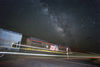
Sullivan's Curve, Cajon Pass Access
Oct 26, 2018 12:34:51 #
bpulv
Loc: Buena Park, CA
Has anyone been up to Sullivan's Curve who can give me detailed information on the dirt road that the topo on https://www.trainmaster.ch/XC-10-2.htm shows and answer these questions questions for me:
1) Is the dirt road passable for an automobile or would I need something more rugged?
2) Is the dirt road well maintained or are there a lot of potholes and large rocks to dodge?
3) How close does the road get you to the curve and how much hiking is there to get to the best photo locations?
4) What is the distance to drive from the access point off Highway 138 and what is the hiking distance to the photo locations at the end of the road?
5) Do I need a day pass from the US Forest Service to legally be on the road?
Thank you
Oct 30, 2018 00:35:04 #
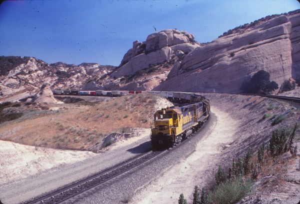
First of all, the access road from 138 is well maintained as it should be given the maintenance crews use it all the time. As to a day pass,? When I was up there no permission was needed, but that was before 9/11. Now you will probably have to contend with the Rangers and the "cinder dicks" AKA railroad police of the BNSF. I remember back in the 80s when a friend of mins and myself went up on the hill late at night. A brace of GP-30 and 35s went around the curve and started small fires along trackside. We stopped at 138 just before the bridge and I went across and down a slight incline to get to the fire. I managed to put out the fire. When I returned to my truck, there were two uniformed cars and one unmarked car parked behind me. They were the Santa Fe police and they wanted to know what we were doing on thier property. I calmly told them that I put out a small brush fire that one od their trains started. Well that deflated their arrogance a few notches and they finally thanked me for putting out the fire. There have been at least three or four times on the hill and curve that we put out fires. We had the Calfire crews thank us for keeping the fires small until they got there. This story give strength to the idea that railfans are not welcome there. Ever since 9/11, we railfains have had a jaundiced eye cast to us as we photograph trains on the hill.
If you do want to go to the curve, take the road from 138, don't go by Cleghorn road. There is a small stream there. We know, we got stuck in it with my friend's Pinto. It is hidden behind the trees. Cleghorn road is the entrance to Sullivan's Curve, but you cannot see the entire curve from there. Now remember that I have not been to the top of the curve since the early 80s, so thing have surely changed. BTW, Summit Pass is pretty much useless to photograph trains form since the state put in a new road. There is no longer a pull-off point to park. I remember when Milepost 57 was a great place to park and shoot both the up and down lines and the SP on their tracks to the Central Valley. RFB
If you do want to go to the curve, take the road from 138, don't go by Cleghorn road. There is a small stream there. We know, we got stuck in it with my friend's Pinto. It is hidden behind the trees. Cleghorn road is the entrance to Sullivan's Curve, but you cannot see the entire curve from there. Now remember that I have not been to the top of the curve since the early 80s, so thing have surely changed. BTW, Summit Pass is pretty much useless to photograph trains form since the state put in a new road. There is no longer a pull-off point to park. I remember when Milepost 57 was a great place to park and shoot both the up and down lines and the SP on their tracks to the Central Valley. RFB
Oct 30, 2018 01:48:48 #
bpulv
Loc: Buena Park, CA
Railfan_Bill wrote:
First of all, the access road from 138 is well mai... (show quote)
Thanks for the info Bill. I sounds daunting. Is there any hiking path in there? If so, how far in and out?
Oct 30, 2018 23:29:02 #
Hey, bp, If I was to hike to Sullivan's Curve, I would start out at Cleghorn road where it turns right to the BNSF access road a few yards from the actual exit. That is where I would hike following the trail to the curve. It looks like it may be driven on, but my experience shows that the wash is very sandy and probably only a 4 by can get across. Hiking should not be a problem except the grade over this terrain can be troublesome. This curve is mainly for Westbound(northerly) trains headed to Barstow, but sometimes there will be an Eastbound (southernly) train going down the curve heading to Los Angeles via San Berdoo. There are many places to photograph train not just at the curve, but also at Mormon Rocks, Blue Cut, and the entrance to the hill going up to the curve. Everyone is great and you will b impressed by the scenery. I remember going up the access road in my Toy PU at 138. We went up to the first tunnel, but I don't recommend that trip now. Too many crazy people there. I was there 30 years ago and the crazies would go to the hill to practice shooting. Crazy! Well good luck and watch out for any nasty things along the trail. RFB
Oct 30, 2018 23:51:09 #
bpulv
Loc: Buena Park, CA
The tunnels are no more. They were bulldozed when they added the extra mainline tracks not too many years back. Where the tunnels were there is now cuts.
If you want to reply, then register here. Registration is free and your account is created instantly, so you can post right away.