Montezuma Pass (PL)
Jan 5, 2018 14:05:21 #

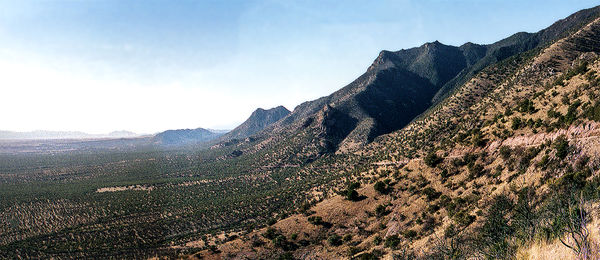
Montezuma Pass overlook southern Cochise County Arizona
This image was stitched from 2, 20 year old(+) negatives. Although the negatives were in sleeves they still took a hit. The road up, down and around the mountains is a narrow dirt cow path that looks like only one vehicle can get through. Not so but deep breaths are required.
google coordinates for the curious 31.352212, -110.286963
Anyway, looking west with Mexico to the left.
Jan 6, 2018 07:48:56 #

On the one hand, attractive image; on the other would hate to work in that land.
Jan 6, 2018 10:21:07 #
BboH wrote:
On the one hand, attractive image; on the other would hate to work in that land.
Thank you. working with those negatives (and some others) has given me renewed appreciation for digital. As to the land there, like every thing else, you can "adjust"

Jan 6, 2018 14:46:47 #
brucebc
Loc: Tooele, Utah
I went over the pass many times cutting fire wood for sale. I lived in Miller Canyon part of the time. The road was pretty good back then, we drove cars over it all the time. Thanks for the photo and the memories that it brought back.
Jan 6, 2018 15:23:57 #
brucebc wrote:
I went over the pass many times cutting fire wood for sale. I lived in Miller Canyon part of the time. The road was pretty good back then, we drove cars over it all the time. Thanks for the photo and the memories that it brought back.
I'm happy that brought you back to the good ol days. When I was working with it I kept wishing I was there right now! (we had a high today of 7°)
If you want to reply, then register here. Registration is free and your account is created instantly, so you can post right away.