Finger Mountain
Oct 19, 2017 06:05:26 #

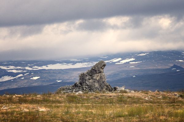
Located Along the Dalton Highway from Fairbanks to Dead horse Alaska. Finger Mountain is a topographical formation in interior Alaska. Not actually a mountain, it is a wide broad hill, with an altitude of around 1312 ft. It is named for Finger Rock, a distinctive granite protrusion on its surface. Back in the early days of aviation, it was used as a location marker that pointed to Fairbanks.
Oct 19, 2017 06:33:23 #
Thanks for the photo! I went whizzing by there in a big Western Star in '88. The trucker pointed it out, but no way was going to slow down for me to get a picture. Just curious, back then, only truckers or oil company vehicles were allowed, what mode of travel did you take, and did you go all the way to Dead Horse?
Oct 19, 2017 06:55:37 #
Actually we were in a van with 12 other people going up to the Artic Circle. It was a tour that went out of Fairbanks. Didn't go all the way, but next time I plan on flying up to Dead Horse. Way too long in a car. That's a scary road, cant imagine doing that in a snow storm.
Oct 19, 2017 07:16:47 #

Alyeska built the "North Slope Haul Road" in 1974 to get materials and supplies to the oil facilities on the North Slope. It was then a private road and you didn't get much past Coldfoot without a permit. However, Alyeska grew weary of maintaining the road so, turned it over to the State, who re-named it the Dalton Highway and it is now a public road and I've been up it many times... in fact, one of my yearly adventures was to drive up and camp at least one night, above the Arctic Circle, during winter.
Oct 19, 2017 07:16:56 #

Oct 20, 2017 08:21:32 #
Oct 20, 2017 13:01:02 #
Oct 21, 2017 00:01:29 #

If you want to reply, then register here. Registration is free and your account is created instantly, so you can post right away.