Posts for: Crichmond
May 8, 2013 22:22:21 #
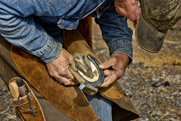
I went to the horse farm over the weekend to capture some images of horses. I was delighted to see the farrier.
A farriers sole trade is shoeing and caring for animals. The job requires the skills of a blacksmith, veterinarian, and an animal psychologist all rolled into one.
Hopefully this image captures a fraction of that story.
Shot with a Canon 60D and Canon 28-200mm Zoom at 145mm, at 1/125, f8.0, ISO 100, and no flash.
Skilled Hands
May 8, 2013 08:30:30 #
Irontruck wrote:
I will do that, I hadn't discovered that feature yet.
Awesome! Have fun!
May 7, 2013 22:42:55 #
Irontruck wrote:
I have not been able to get the frame behind part of the picture. I haven't had much time today to work with the program but I won't give up until I figure the program out.
Cool pics!
Have you viewed the tutorial under help?
May 7, 2013 19:23:02 #
Irontruck wrote:
I did download the app, is there any written tutorials to use the program? I seem to be missing something in using it. I have had partial results like getting the subject to go out of bounds of the frame. If you have other information on using the app it would be appreciated.
Hi Irontruck!
By app do you mean "OutColor2"?
Thanks!
Crichmond
May 6, 2013 22:26:42 #
pageva wrote:
beautiful lighted statue at the hospital, but could not shoot detail. As I said in previous post, didn't have my tripod.
I would try HDR.
May 6, 2013 17:36:04 #
May 6, 2013 17:23:51 #
Puglover wrote:
Have fun! I downloaded a few OOB pictures if you want to see them
Hi Terri!
I would love to see your photos, where may I find them?
thanks!
crichmond
May 6, 2013 10:24:56 #
Puglover wrote:
I looked up OOB CS5 on the computer and lots of info came up. If you have an ipad there is an app called OutColor 2. That is what I mainly use to make my pictures. I warn you it is addictive. Have fun.
Hi Puglover!
Thanks for the tip. I downloaded the app. It is way cool! Much easier than PS.
Thanks!!!
Crichmond
May 4, 2013 12:45:03 #
BrettOssman wrote:
If anyone is interested, I'm dabbling with a new blog (Average Joe Photography). It's my personal photography experiences using my, not so high-end, equipment; as well as mainly local trips. Hoping to show folks what can be done, as well as learn what I can do, without high-end equipment and expensive photo excursions.
http://averagejoephotography.blogspot.com
http://averagejoephotography.blogspot.com
Hi Brett!
Thanks for the link - I bookmarked & plan to follow your blog. Interesting concept - thanks!
Crichmond
May 3, 2013 23:57:21 #
bdo wrote:
Crichmond,
It's hard to thank you enough for the detailed information. It's exactly what I need to get me started in the right directions.
I'll be sure to post some photos when I get back, mid-June. It's going to be hard to wait that long.
It's hard to thank you enough for the detailed information. It's exactly what I need to get me started in the right directions.
I'll be sure to post some photos when I get back, mid-June. It's going to be hard to wait that long.
bdo
I'm glad you are pleased.
Travel well, have a good time, and be safe.
Crichmond
May 3, 2013 20:03:29 #
bdo wrote:
I have a chance to head out into NW Colorado the first week of June, around Craig, Meeker, Rifle, Dinosaur National Monument, etc.
I'm looking for suggestions for photo opportunities, especially landscape and wildlife, but also historic sites, or anything interesting in that neck of the woods
Short off-road hikes are OK, but I'm getting too old to get too far off a road. Back roads are fine, as I have an AWD vehicle.
So let me know what you all suggest.
Thanks.
Hi!
The DeLorme map book for Colorado is an excellent choice. You definitely will have a need for it. Moffat County has vast acres of Government land - BLM, Forest Service, etc. Delorme will help identify the government land from the private land as well as provide directions to get to your destination.
I would suggest, upon entering Craig, stopping by the Chamber of Commerce right on the main drag (Victory Way) and spend a few minutes to pick up any brochures you have interest in and maybe chatting with someone to glean any information that might be of help.
Right across from the Chamber is the Marcia train car, and the entrance into the city park. Both the train car and the wood carvings in the park might provide some photo ops.
I'd like to mention two other spots in Craig that may be worth your time. The first is Loudy Simpson Park. It is located on south Ranney Street just across the Yampa River. You can drive through the park to within 50 feet of the river. That might provide an opportunity for an evening shot of the Yampa River, trees, sizable hills in the background and a sunset. You might get lucky and see some deer crossing the river.
Another place in Craig for sunset shots would be up on the sand rocks. Take Yampa Ave north to 13th. Hang a left (west) until 13th dead ends. Take the gravel road up the hill and you are on the sand rocks. This will give you a vista of Craig. You can literally see for miles. However, be warned, we lived just below the sand rocks and had mountain lion tracks in our yard, so keep an eye for a big cat.
Craig is at the junction of Co Hwy 40 and Co Hwy 13. I've already addressed going south out on Hwy 13 to Meeker, and you have already entered Craig from the east on Hwy 40, so I will concentrate on going west on Hwy 40, and going north on Hwy 13.
My guess would be that you will travel west at least two of the days. Two days will not allow you to cover everything west of Craig, but you will probably be able to take in the major areas.
As you head west out of Craig on Hwy 40 you will approach a spot on the map called "Lay." Across the road from lay is a small buffalo ranch/farm. Its not spectacular, but at least worth mentioning.
A little further down the road on the right is a small red building. It is an historical site for some politician that grew up in Moffat County - Gov Edwin Johnson. I never found it of much interest, you might.
Further down the road you'll cross over the Yampa River just before you get to Maybell. Depending on the time of day, and the lushness of the grass there may be a photo op. You can easily determine that as you drive along. Maybell isn't much. A small general store, a park, cemetery, maybe a diner, and it is the last chance for gas until you get to Utah. So if you haven't topped your tank off, you might want to stop and do so.
Shortly out of Maybell you will have to decide on going on to Elk Springs and the main entrances to Dinosaur National Monument, or taking 318 through Sunbeam to Brown's Park.
For now we are going to take 318 and head through Sunbeam on towards Brown's Park. Sunbeam is a small collection of homes and a post office. That's it - no more, however as you drive along you may see wildlife, and the scenery isn't to shabby either.
Later, you will cross the Little Snake River, and head towards Irish Canyon. This area is rife with cowboy and outlaw history. Back in Craig you could visit the Craig Museum (its free) and learn a little of its history. I think Dan Davidson is the curator, and upstairs there is quite an interesting gun collection (photo op). Anyway, back to Irish Canyon. Check the maps, if I remember correctly there are petro-glyphs at the entrance of the Canyon. They are quite easy to access.
Points of interest in Browns Park:
Gates of Ladore - definite photo op
Ladore Hall - possible photo op
Vermillian Falls - creek might not be running, so there may or may not be a water fall
Coke Ovens - photo op
Swinging Bridge - photo op
and on down the road - Jarve Ranch - definite photo op
I would pick up the brochure on Brown's Park at the Craig Chamber of Commerce. It has a detailed map of the area - it is more inclusive than Delorme.
It will probably take the better part of a day to get to all of the above places.
You have a choice for your return to Craig. You can return the way you came, or if you are a bit adventuress you could head back east and take county road 25 south to twelve mile gulch. That will put you at the confluence of the Little Snake River and the Yampa. South of the confluence is Cross Mountain - another definite photo op, and right of the confluence the road dead ends at Deer Park Lodge. South of Cross Mountain, just a couple of miles is Hwy 40. Take a left (east ) to get back to Craig.
Another day trip might be to Dinosaur National Monument. Take Hwy 40 east past Lay, Maybell, Elk Springs, Blue Mountain and then just before you get to the town of Dinosaur take a right the monuments' entrance. There are some spectacular views of the Green River Canyon
from this entrance. If you want to get down to Echo park and Steamboat Rock you will need a little more than what Delorme has to offer. Again the Craig Chamber of Commerce can help you with a BLM map or maps to get to them. This will a pretty full day. If you are interested in Dinosaur bones you'll have to proceed west on Hwy 40 into Utah to that Park entrance. I believe there is a fee to do that..
Another day might be spent on Black mountain. Look on page 15 of the Delorme Map. Head north of Craig on Hwy 13. Take a right at the saw mill (County Road 27). Co Rd 27 turns into FR 110. Follow FR 110 to FR 116. That will take you to Bears Ears. Go back to FR 110, take a right and you will end up on Slater Creek Road (Routt County Road 82 which turns into Moffat County Road 1.) If you go right you will being heading north and will wind up on Wyoming Hwy 70. At Hwy 70 you can turn right to get to Savery, Wy, or Left to Bags. By now you're probably a little tired, so you should head to Bags, which takes you to Wy Hwy 789. Take a left (heading south). This will turn into Hwy 13 and take you to Craig.
At the right time of year, one of the prettiest areas around Bags is CC Road 702. It is located north on Hwy 789. It will do a loop and bring you back to Hwy 70.
So if you go to Brown's Park, Dinosaur National Monument, Black Mountain and Meeker that will be four very full days.
Two other trips to consider are:
The loop along Elkhead Reservoir (back east on Hwy 40 to county road 29, to county road 18, to Hwy then back to Craig. This is mostly Moffat County Farm ground. There are some interesting old buildings along the way, a view of Bears Ears and Sugar Loaf Mountain.
Or Great Divide which is north and west of Craig on county road 7 which turns into county road 3. There is no guarantee but I seem to always run into antelope on county road 3 near Great Divide. Great Divide isn't much. Just a spot on the road, and maybe an old building or two.
Godiva Rim is another one to mention as well. It is on page 13 of the Delorme Map Book. To get there you take the Sunbeam road to the Little Snake River. Turn right on County Road 21. The access rood to Godiva is maybe a mile and half from the intersection on the right. Godiva is a ridge with vast expansive views back towards the south and east.
Last but not least, the best two places to eat in Craig are the OP (Other Place) located on the east side of Craig on Victory Way, and the Golf Course - located at the golf course.
Well that's enough information to get you thoroughly lost.
Have a good trip and stay safe.
Thanks!
Crichmond
May 2, 2013 23:47:00 #
bdo wrote:
Wow!! br br From what I have learned just surfing... (show quote)
Hi!
Travel time from Boulder to Craig will be a minimum of four hours maybe more, depending on the traffic on I70.
The drive from Boulder to Craig will also provide many photo ops.
In your travel to and from Boulder you might consider going over Berthoud pass to Winter Park, and returning via CO 9 out of Kremmling to Silverthorn and through the tunnel.
Either way you will pass through Steamboat where you could take a short jaunt up to Fish Creek Falls. Definitely worth the time. (It does involve a short walk, and you have to pay to park)
Oh, and don't forget Rabbit Ears - a rock formation to the north of Hwy 40 on Rabbit Ears Pass. (another photo op)
Oh, and you might be interested in the George Town Loop - a steam engine/train outside of Georgetown. There is a pull off the interstate. You just might catch the train puffing smoke as it pulls the load up the hill.
I'll put a list together of suggested areas based out of Craig, and your stay being around four days. I should have it for you in a couple of days.
By the way, Old town Meeker would definitely be worth your time. Meeker is an easy 45 minute drive out of Craig. Just have to watch for deer and elk on the highway. If I were to go to Meeker I would also consider the White River east out of Meeker. Its beautiful scenery with plenty of photo ops. Actually you could make a loop out of it. The trip would be 45 minutes from Craig on the highway 13 to Meeker. An hour or two in Meeker, then east on county road 8 up the canyon. County road turns up a switch back towards pyramid peak (definite photo op) and runs into CO 317 which ends at Hamilton, however four or five miles (maybe six or seven) before Hamilton you could take the Knez Divide to the north and go over the ridge to Craig. There is an old cabin - ranch house on the east side of the road just before you crest the ridge - another photo op.
You should have fun.
Talk to you soon.
Thanks!
Crichmond
May 2, 2013 22:34:50 #
bdo wrote:
I have a chance to head out into NW Colorado the first week of June, around Craig, Meeker, Rifle, Dinosaur National Monument, etc.
I'm looking for suggestions for photo opportunities, especially landscape and wildlife, but also historic sites, or anything interesting in that neck of the woods
Short off-road hikes are OK, but I'm getting too old to get too far off a road. Back roads are fine, as I have an AWD vehicle.
So let me know what you all suggest.
Thanks.
I'm looking for suggestions for photo opportunities, especially landscape and wildlife, but also historic sites, or anything interesting in that neck of the woods
Short off-road hikes are OK, but I'm getting too old to get too far off a road. Back roads are fine, as I have an AWD vehicle.
So let me know what you all suggest.
Thanks.
Hi BDO!
I spent over 24 years living and working for the electric utility out of Craig. I know the area well.
There are tons of photo opportunities in the area including landscapes, historical sites, and sunrise and sunset options as well.
There is a plethora of wildlife - antelope, deer, elk, wild horses, bald eagles, golden eagles, hawks, rattlesnakes, bobcats, mountain lions, and a horde of small animals as well. And don't forget the fishing.
Craig, Meeker, Rifle, and the Dinosaur National Monument covers a vast area.
I would be delighted to give you a list of places you might be interested in. It would be helpful to know the approximate length of time you plan on spending in the area, and where you intend stay. The list I would provide should you choose Craig as your base would differ from Rifle, Meeker, or Dinosaur. Yes, there is a town called Dinosaur outside of the Monument.
You will be able to drive to most of my suggestions. There would be very little hiking.
I would suggest that each day you top the gas tank off because of the distances you will likely travel with no opportunity to acquire gas. Always have plenty of drinking water. The best cell phone coverage for the area is Verizon or Union (aka Union Cellular). All other carriers have very sparse coverage.
Looking forward to hearing from you.
Crichmond
Apr 26, 2013 10:09:43 #
EPT wrote:
I have a Canon 7d and a wide variety of equipment. However, there are times I would like to just carry a small (shirt pocket), high quality point and shoot camera. I have been doing some research, but does anyone have some recommendations, cost is not a significant barrier.
I would vote for a Canon G1X, or the SX50.
Apr 26, 2013 10:07:30 #
plewislambert wrote:
Have you found that taking pictures using a tripod and delayed action release gives you a sharper picture?
Philip
Philip
Do you mean mirror lockup? (Canon terminology)?