Question about Geo-tagged images
Nov 17, 2021 06:48:05 #

I understand there is software available to allow you to locate and replay geo-tagged images on a geographical map. Any suggestions? Your input will be appreciated.
Nov 17, 2021 06:59:13 #
Chemwood
Loc: UK
Hi, I used to have a Canon 6D which had this facility via Lightroom . Now changed totally over to Olympus and my only regret is the lack of this function. Debating about getting another 6D as back up just for the GPS.
Nov 17, 2021 07:05:28 #
Chemwood wrote:
Hi, I used to have a Canon 6D which had this facility via Lightroom . Now changed totally over to Olympus and my only regret is the lack of this function. Debating about getting another 6D as back up just for the GPS.
Thank you. I believe the software available is not camera dependent as long as the location coordinates are included in the image information. Perhaps a Google Map feature?
Nov 17, 2021 07:34:52 #

Julian wrote:
I understand there is software available to allow you to locate and replay geo-tagged images on a geographical map. Any suggestions? Your input will be appreciated.
To have a real geotag, it needs to be done at the camera level, either integrated or an accessory. Anything else must be done by hand.
There is no if/but here.
Google allows drop/drag of an image to a location if it has no geotag. Google requires you to have an account. This by the way does not create a geotag.
Nov 17, 2021 07:41:58 #
On Windows, IrfanView (freeware) can do that.
Open an image file. Press "i" for Image Properties. On the dialog that appears click on the "EXIF" button. The EXIF dialog will appear and if there is geotag information in the file it will display two buttons: "Show in Google Earth" and "Show in Google Maps"
I don't have a Mac so I don't know what software will do that.
Nov 17, 2021 13:41:39 #
Rongnongno wrote:
To have a real geotag, it needs to be done at the camera level, either integrated or an accessory. Anything else must be done by hand.
There is no if/but here.
Google allows drop/drag of an image to a location if it has no geotag. Google requires you to have an account. This by the way does not create a geotag.
There is no if/but here.
Google allows drop/drag of an image to a location if it has no geotag. Google requires you to have an account. This by the way does not create a geotag.
I asked the question because I already have a GPS device connected to the camera; the location coordinates as well as altitude appear on exif information for that particular image. So again, is there a software available that can pinpoint the location a a map?
Nov 17, 2021 14:36:03 #
Nov 17, 2021 14:46:45 #
Julian wrote:
I asked the question because I already have a GPS device connected to the camera; the location coordinates as well as altitude appear on exif information for that particular image. So again, is there a software available that can pinpoint the location a a map?
ACDSee
Nov 17, 2021 14:55:41 #
ronWA
Loc: Western Washington
Rongnongno wrote:
ACDSee
I use an iPhone and Sony a55 to take coordinates and Lightroom plots them on a map.
Ron
Nov 17, 2021 15:52:40 #
Nov 17, 2021 17:21:18 #
I’m not a Mac guy but Lightroom will do what you want in the map module. Don’t know about any other software.
Nov 18, 2021 09:27:03 #
gvarner
Loc: Central Oregon Coast
Chemwood wrote:
Hi, I used to have a Canon 6D which had this facility via Lightroom . Now changed totally over to Olympus and my only regret is the lack of this function. Debating about getting another 6D as back up just for the GPS.
Use a cellphone to geo-tag a location.
Nov 18, 2021 09:43:50 #

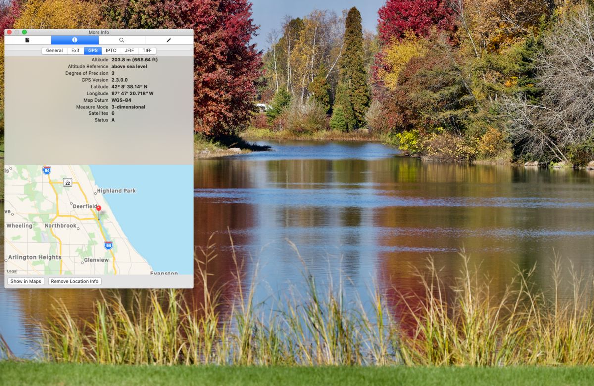
If your photo is in your "Photos" Library go to image>Edit with> Preview>Tools>show inspector>GPS
Nov 18, 2021 11:01:25 #
If you have LR Classic, then use Map tab. All photos with geotags will be displayed on the map accordingly. If you need to correct the location or assign/reassigned of a photo just drag it within the map.
Nov 18, 2021 11:05:16 #
Hsch39 wrote:
If your photo is in your "Photos" Library go to image>Edit with> Preview>Tools>show inspector>GPS
Your example appears to be on a Mac.
Windows also has a program called "Photos" but I don't see a way to use the GPS metadata within that program.
Windows File Explorer can show you properties of the image file and the details tab will show you the GPS data if it is there, but there is no link to automatically use those data.
(Using Win10)
If you want to reply, then register here. Registration is free and your account is created instantly, so you can post right away.