Taking a trip to lake Tahoe and then down to Mono lake the end of October.
Sep 29, 2016 13:23:32 #

We're driving from Alberta to Crater Lake, over to Lake Tahoe, then down the eastern side of the Sierras to Mono Lake area. We're going to leave home the last week of October. After Mono we plan to drive through Death Valley and on over to Vegas on our way to Mesa, AZ where we spend the winter months.
Any routing tips or not to miss photo ops would be appreciated.
Any routing tips or not to miss photo ops would be appreciated.
Sep 29, 2016 13:26:51 #
Bodie Ghost Town, a few miles south of Bridgeport and 13 miles in on a dirt road. Worth every bump.
Sep 29, 2016 13:28:27 #
Definitely go to Bodie, an excellent place to take pics - an old ghost town. It's not far from Mono Lake. Expect a dirt road and no cell service.
Sep 29, 2016 13:56:17 #

After Mono Lake, I would suggest that you keep going south on US 395, past Mammoth Lakes, through Bishop, Big Pine, Independence, and Lone Pine. At Lone Pine you can turn east to get to Death Valley. If you are driving
There are a lot of photo opportunities along this route. Stop by a Visitor Center, somewhere along 395 and get a free publication on US 395.
If you will be pulling a trailer or driving a Motorhome, I would suggest that you stay on 396 until you get to Ridgecrest then cut over to Death Valley.
There are a lot of photo opportunities along this route. Stop by a Visitor Center, somewhere along 395 and get a free publication on US 395.
If you will be pulling a trailer or driving a Motorhome, I would suggest that you stay on 396 until you get to Ridgecrest then cut over to Death Valley.
Sep 29, 2016 14:01:24 #
Before you turn left to Death Valley at Lone Pine, turn right and explore the Alabama Hills area. It's just a bit off the highway and is a photographers playground.
Sep 29, 2016 16:31:00 #
Depending on the weather, it's possible to get snow, so be flexible at that time of year.
Bodie is pretty high up too.
Also if the pass is still open, you're only a few hours from Yosemite. Probably one of the biggest photo ops on the planet!
You'll be in bristlecone country as well. Lots of options, depending on what you like to photograph. :-)
SS
Bodie is pretty high up too.
Also if the pass is still open, you're only a few hours from Yosemite. Probably one of the biggest photo ops on the planet!
You'll be in bristlecone country as well. Lots of options, depending on what you like to photograph. :-)
SS
Sep 29, 2016 19:25:57 #
There is also the Manzanar Historic Site near Lone Pine, Ca. If there ever was a place that despair pervaded the air this would be it.
Sep 29, 2016 19:58:54 #
Sep 30, 2016 02:16:46 #
choward_ab wrote:
We're driving from Alberta to Crater Lake, over to Lake Tahoe, then down the eastern side of the Sierras to Mono Lake area. We're going to leave home the last week of October. After Mono we plan to drive through Death Valley and on over to Vegas on our way to Mesa, AZ where we spend the winter months.
Any routing tips or not to miss photo ops would be appreciated.
Any routing tips or not to miss photo ops would be appreciated.
A relatively unused route, but one of my favorites for scenery is Kingsbury Grade (Nevada Route 207) IF the roads are clear AND you have good brakes (dynamic braking highly recommended).
PM Harvey; he lives up there and knows the area like the back of his hand!
Sep 30, 2016 11:32:29 #
choward_ab wrote:
We're driving from Alberta to Crater Lake, over to Lake Tahoe, then down the eastern side of the Sierras to Mono Lake area. We're going to leave home the last week of October. After Mono we plan to drive through Death Valley and on over to Vegas on our way to Mesa, AZ where we spend the winter months.
Any routing tips or not to miss photo ops would be appreciated.
Any routing tips or not to miss photo ops would be appreciated.
apologize for the typos...hope this helps you a bit...took about 5 hours to assemble this for ya....
There are an amazing amount of things to see and photograph in this area. Added bonus is you are going at a time of year when you will get areas of fall colors as well!!
...Bodie Ghost Town as somebody mentioned already...paved road for a bit east of 395, then turns into a dirt road...kind of slow going for about the last 4 miles or so but well worth it...There are some good possibilities for fall colors as you first start up the road to Bodie after you turn off 395 as well as some areas to the west of 395 in that area..
http://www.parks.ca.gov/?page_id=509
After Bodie as you go south on 395 towards Lee Vining...make a stop on the overlook before you go down to Mono Lake....pretty nifty view of Mono Lake, the Mono Craters, and the June Lake Loop area...clouds if any...
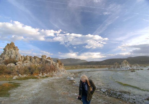
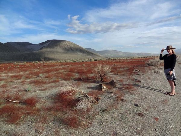
Then there are the tufa formations of Mono Lake...two places to see it..one at Lee Vining .and then another turnoff via HWY 120 for about 6 miles east of 395 to the biggest tufa viewing area ....and before you get there on your right are some fantastic brown colored shrubs with the Mono Craters in the backdrop just to the right of road 120 as you go towards the tufa formation parking lot ..... Cloud formations in the June Lake and Mono Lake area can be spectacular..
http://www.monolake.org/about/geotufa
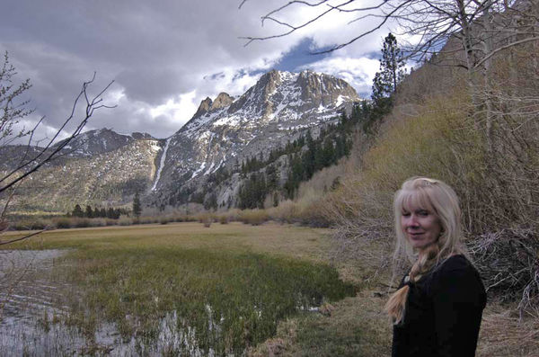
Of course right there west of 395 is HWY 158 which is the June Lake Loop road with June Lake and Silver Lake being my favorites.. At Silver Lake on the NW corner...kind of mid lake area... is a large parking area pullout that you have to get out of your car and walk about 50 yards for a just spectacular photo area with the Sierra Nevadas in the background... the north perimeter of Silver Lake has some boats usually stored that can make a good subject matter stop...and just a tiny bit further up as you go on 158 back east towards 395, between Silver Lake and Grant Lake , is a cattle/ranch photo op on the left side that has a dramatic western flavor to it with the high mountains in the background and at this time of year seams of trees changing colors on the sides of the cliffs where there are gullies (where water flows)...Again this will be in deep shadows in the afternoon so the sun angle become critical for good overall exposures...things can get pretty constrasty if you are not mindful of when the best hours are to photograph the east side of the Sierra Nevadas.......
Again...the best time to generally photograph that entire area is the morning in October through about 1 or 2 PM at the latest since it all can get into shadows pretty fast since the Sierras run N/S ....you want good eastern type of light or suffer the consequences of shadows in the late afternoon hours this time of year.... You might luck out and get some snow up on the Sierras...which in the Spring for example can really punch of the photos in this region.. If you miss the good hours, you may have to do in camera HD stuff to capture everything properly exposed...
http://junelakeloop.com/
The next area to consider is just 25 minutes away to the south on 395 and that would be the Mammoth Lakes .....this area is spectacular in the Spring due to the snow on the Sierras....keep in mind during the winter, a lot of these roads can be closed due to the snow.. Gorgeous scenery on the roads that go along the east side of the lake complex there...NOT TO BE MISSED...I have kind of short changed this but it is as worthy as anything else along this route!!!
http://www.allmammoth.com/scenic_drives/minaret_summit_road.php
http://www.cityconcierge.com/mammoth-lakes/activities/june-lake-loop.asp
As you come back to 395 and go further south you descend into Bishop...on your right side with fall leaves this time of year is a huge valley pastor land with the Sierras in the background..OMG...This is so beautiful...horses and cattle and trees changing colors....lots of people just zip on past this area and into the town of Bishop....at the top of the grade if you can find the turnoff... ..is Old Sherwin Grade Road....so instead of going down 395, you descend into this pastoral setting on Old Sherwin Grade Road....it eventually goes through a residential area on the north side as you descend and then down into this enormous valley ......Best time for this area in OCT would be 10 AM to about 2 PM or so though the evening sunlight on the trees changing colors with the horses and cattle is OK too but the Sierras will be in shadows ...If you miss Old Sherwin Grade Road ...which is EASY to do if you do not have GPS ... simply go down 395 and turn off Pine Creek Road and enter this farm land area that way..... If there are fall colors, they start immediately after you leave 395 into this pastor land.... Jaw dropping western scenery..but it needs strong midday light at least!!!! If you have the hours in the day.....you can time this pretty good with sunlight hitting these fall leaves and have a dark backdrop of the High Sierras for a while since the sun will be more to the south over toward the Lake Sabrina area......You just have to kind of figure it out but there are some dramatic possibilities .....You just have to check it out but doing drive by photography in this region would not be recommended....
https://www.google.com/maps/place/Bishop,+CA+93514/@37.3664996,-118.4153651,14z/data=!3m1!4b1!4m5!3m4!1s0x80be16019ea66407:0x13cd1e4d95e98916!8m2!3d37.3614238!4d-118.3996636
https://www.mapquest.com/us/ca/bishop-282033231
Also if you have time ....out of Bishop is a rare road that penetrates into the Sierra Nevadas which is Highway 168 up to Lake Sabrina....Lake Sabrina can be nearly empty or full due to how they are controlling the water up there but there are plenty of fall colors in the last 5 miles of this very easy to use fully paved road SW of Bishop....Lots of vistas of the Sierra Nevadas both on the flat and as you ascend towards Lake Sabrina on Hwy 168....Well worth the side trip!!! You might want to use a good zoom lens of 200mm or more in this region.....Down in this part of the Sierras, you don't get too many paved road to get this close to the High Sierras...Highway 168 is one of them...
http://www.lakesabrinaboatlanding.com/
The next big deal stop after the Manzanar Camp just a few miles north of Lone Pine...
https://www.nps.gov/manz/index.htm
is the Alabama Hills that Ansel Adams made famous...and also the drive up to the Mt. Whitney Trailhead...Whitney Portals.... you can sometimes be lucky and get standing lenticular clouds in this Mt. Whitney/Alabama Hills section which can be very dramatic.....The Alabama Hills area is pretty dusty but easy to do dirt roads throughout so expect your vehicle to get a bit covered with dust....Now there is a little known/traveled paved road extension on Horseshoe Meadow road that takes a death defying steep climb up the side of the Sierra Nevadas for about 10 miles or so that will leave you wondering why you did it...I cannot even describe it adequately ..you would have to go to google earth and see if it is something you would want to try though you don't have to go all the way to the top of course...The series of switches to the top are "special". Not for the faint of heart..
https://en.wikipedia.org/wiki/Alabama_Hills
https://en.wikipedia.org/wiki/Whitney_Portal,_California
images of Horseshoe Meadows Road are among the images in this link.....OMG!!
https://www.bing.com/images/search?q=horseshoe%20meadows%20road%20photos&FORM=HDRSC2
https://www.bing.com/mapspreview?&ty=18&q=Lone%20Pine&satid=id.sid%3a8ffde840-f5be-2a61-e1e5-4e79735c11da&vdpid=5060169555301629953&mb=36.653591~-118.116081~36.512714~-118.040962&ppois=36.6045188903809_-118.062812805176_Lone%20Pine_~&cp=36.604519~-118.062813&v=2&sV=1
You can spend an entire day in the Alabama Hills for photography....just amazing....but VERY IMPORTANTLY this is best done from 8 AM to about 1 PM or so during October so you get the full eastern light on the Sierras...I cannot emphasize enough this fact!!
The off to the Death Valley which is a whole different ball of wax!!!
If you go to Vegas...you must include Red Rock Canyon Conservation Area (you can actually see it from the Las Vegas Strip to the west... a must do. It has a relatively new visitors center now..
http://www.blm.gov/nv/st/en/fo/lvfo/blm_programs/blm_special_areas/red_rock_nca.html
another must, must do is the Valley of Fire State Park up an hour or so north up I-15...one of the most beautiful but most overlooked red rock formation areas in the USA..all the park facilities and roads have recently been improved and this is a must, must do park!!!
http://www.valley-of-fire.com/
Also another overlooked area just 30 minutes from Vegas is Mt. Charleston and the loop to ski area....You can NEVER imagine such alpine beautify THAT CLOSE TO VEGAS!!!!! You take U.S. 95 to get there...The Mt. Charleston Lodge restaurant is really great as well!!!
The Mary Jane Falls Trail with autumn leaves nearly surrounded by peaks reaching up close to 12,000 feet is the most UNEXPECTED thing you would ever think of regarding the mega city sprawl of nearby Las Vegas...
htttp://www.gomtcharleston.com/
The brand spanking new Spring Mountains Gateway Center is a must stop and see place...great picnic area and lots of trails right there in front of the center ...YOU WILL NEVER BELIEVE you are this close to VEGAS being at a place so opposite desert type of scenery...
http://www.gomtcharleston.com/uploads/MT_CHARLESTON_GUIDE_SUMMER_2015.pdf
Mt. Charleston Lodge
http://mtcharlestonlodge.com/
this has a great map in this file of the Mt. Charlestons area...
https://fs.usda.gov/Internet/FSE_DOCUMENTS/fsm9_026404.pdf
finally not to be missed is the Hoover Dam Bridge ..in a car you cannot see over the edge due to concrete barriers ..so you cannot see the dam .....However there is a huge parking lot for a concrete sidewalk up to the bridge that you can walk fully across to the AZ side...this along with the dam area itself is a VEGAS must do toruist destination now since they have built a visitors center, cafeteria, parking structure, and museum....you can really get some fantastic archectural type photos of bridge from some pullouts as you descend to cross the dam itself....all well worth the drive down south of Vegas .......The parking area to the pedestrian path across the bridge is on the right hand side as you go down the road to the dam....you can't miss it...
The Hoover Dam Pedestrian Walkway
http://bestlasvegasdetours.com/tours-from-las-vegas/hoover-dam-bridge-pedestrian-walkway/
hope this info helps a bit with the links....Like I said, Death Valley is a whole different topic from Scotty's Castle to Ubehebe Crater to Furnace Creek Resort and Ranch to the Devil's Golf Course to Badwater Basin to Zabriskie Point, to the Mesquite Flat Sand Dunes near Stovepipe Wells...whole different ball of wax...
https://www.nps.gov/deva/index.htm
hope you have enough time!!!!....sorry for the typos....I did not include any Mammoth Lake photos but you cannot miss that .....but anything at Mammoth Lake regarding the lakes there are as worthy as ANYTHING mentioned here...MUST SEE stuff!!!
So between Bodie Ghost Town and Lone Pine you could spend a long time...and if you just went to do only photography, you could mine this area for decades since you do get stunning seasonal changes in this swath of CA that give you totally different "looks" all the time...
photo 1....Mono Lake tufa area .use Road 120
photo 2....Mono Craters...just off of Road 120 from Hwy 395 on the way to the Mono tufa parking area....the color of these shrubs is unique..
photo 3... Silver Lake on the June Lake Loop at mid point turn off parking area...NW side...you have to get out of you car and walk 50 yards down a path to get this view or you cannot see it from road 158
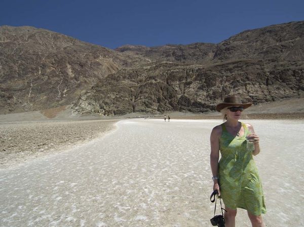
photo 4...Badwater Basin salt flat Death Valley ..lowest point in North America (if you take away going to the bottom of the some of the Great Lakes).
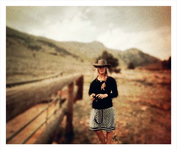
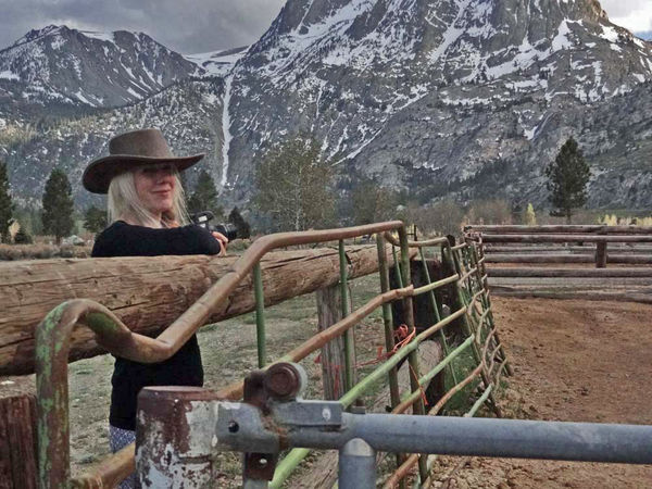
photo 5...Cattle ranch next to the west side of road 158 between Silver Lake and Grant Lake on the June Lake Loop.
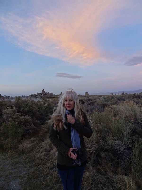
photo 6...Sunset on Mono Lake...again cloud formations in this area are simply breathtaking...good photo op to do some B/W here as well..
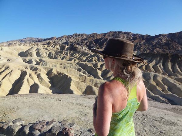
photo 7...Zabriskie Point Death Valley
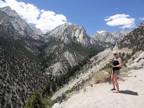
photo 8...road on the way up to Whitney Portal about 15 minutes west of Lone Pine, CA
photo 9....2nd photos of cattle ranch next to the west side of road 158 between Silver Lake and Grant Lake on the June Lake Loop
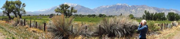
photo 10...on the flat area of Old Sherwin Road just north of the town of Bishop ...taken in the spring but all these trees change colors in October...Classic pastoral area that is hard to duplicate at least in CA...paved roads throughout this very extensive valley...you could spend weeks here alone photographing this wonderful real estate re the mountains, trees, creeks, clouds, horses, cattle, roads, green fields, barbed wire fences..etc.. etc...no developed neighborhoods destroying this pristine flat area near Bishop.
My partner lives in Canterbury, Kent, England so this is quite a drastic change for her though as many times as I have been to this area of CA, I am just as thunderstruck by this awesome scenery as she is.
(Download)
(Download)
(Download)
(Download)
(Download)
(Download)
(Download)
(Download)
(Download)
(Download)
Oct 1, 2016 14:15:04 #
Thanks soooo much - really appreciate you taking the time to put this together!
If you want to reply, then register here. Registration is free and your account is created instantly, so you can post right away.