GPS photo tagging
Jun 6, 2013 13:16:45 #
duanes wrote:
I needed a new camera right when Cannon released their new 6D full frame sensor which has built in GPS as well as WI-FI. Of course it does eat up the battery much more quickly so be sure to bring spare batteries on a shoot.
I figure the GPS will help me get home if I get lost. Or at least get me back to the car. :D
Jun 6, 2013 14:06:22 #
Gibar wrote:
I have been interested for some time in GPS taggin... (show quote)
I've been using the Qstarz BT-Q1000XT GPS data logger for a couple of years now and love it. (Actually, I now have two because I lost the first one and found it only after buying a replacement) There is no need for any other photo software either. Just download your photos to the computer, start the Qstarz application and then download the GPS track log and when you point it at the folder containing the photos, it automatically imports the coordinates into the exif file of each photo. I had forgotten to update my camera after daylight saving time started, but the software has a time shift function too. I simply adjusted the time stamp one hour ahead for the entire group of photos and it corrected the mistake across the board. It can adjust by the hour, minute and even seconds, so precise adjustment is possible even if you're off my an odd amount.
Jun 6, 2013 14:19:27 #
heyrob wrote:
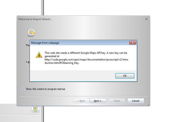
I've been using the Qstarz BT-Q1000XT GPS data log... (show quote)
I got the same unit last week, and I installed the software. When I run QTravel, I get this message on the screen. I got the key by following the directions, but there is no indication of what to do with the key.

Jun 6, 2013 14:25:38 #

jerryc41 wrote:
I got the same unit last week, and I installed the software. When I run QTravel, I get this message on the screen. I got the key by following the directions, but there is no indication of what to do with the key.
Maybe this link will help.
https://developers.google.com/maps/signup
Jun 6, 2013 14:30:56 #
Gibar wrote:
Thanks, but I read that when I was trying to sort it out. Gibberish on top of gibberish. I'll get back to the QTrack device eventually. It will (hopefully) communicate with a little receiver attached to my camera.
Can you click on the QTravel program and have it run?
Jun 6, 2013 14:41:28 #
jerryc41 wrote:
Thanks, but I read that when I was trying to sort it out. Gibberish on top of gibberish. I'll get back to the QTrack device eventually. It will (hopefully) communicate with a little receiver attached to my camera.
Can you click on the QTravel program and have it run?
Can you click on the QTravel program and have it run?
I really can't answer that question Jerry, as I use Time Album for my GPS device, and all I use Time Album for, is to convert the GPS track to a GPX file which then Lightroom will read. Sorry I couldn't be of more help.
Jun 6, 2013 14:53:53 #
Gibar wrote:
I really can't answer that question Jerry, as I use Time Album for my GPS device, and all I use Time Album for, is to convert the GPS track to a GPX file which then Lightroom will read. Sorry I couldn't be of more help.
OK. QTravel came with the device, so I thought I'd use it, but maybe not. It would be nice to plot my route on a map, even if I'm not coordinating with photos.
Jun 6, 2013 15:01:34 #
jerryc41 wrote:
OK. QTravel came with the device, so I thought I'd use it, but maybe not. It would be nice to plot my route on a map, even if I'm not coordinating with photos.
If you have a way of converting your GPS logs to a GPX file format then in Lightroom it will plot your course as well as tag your for photos in the map module of Lightroom.
Jun 6, 2013 15:10:14 #

heyrob wrote:
I've been using the Qstarz BT-Q1000XT GPS data log... (show quote)
GPicsync does the same thing but I do believe the time value must be pretty close.
Jun 6, 2013 17:02:04 #
ramapo
Loc: New Jersey
I generally carry my Garmin Dakota 20 as I use the other features in addition to just collecting a tracklog. I now use the Geoencode Lightroom plugin. This replaced GPisync, which worked great but was an added step.
I did get the Nikon GP-1 that sits in the hot shoe on my D3100. It works ok at best. It has a much harder time acquiring and especially maintaining satellite reception so I almost always have photos without gps coordinates.
In a pinch, I'll use my iPhone to collect gps data but that is a sure way to use up the battery quickly.
I like the idea of having a cheap, reliable tracker/logger to carry when I don't need all the features of the Garmin. What device are you using?
Jun 6, 2013 17:42:21 #
ramapo wrote:
I generally carry my Garmin Dakota 20 as I use the... (show quote)
Columbus V 900
http://www.youtube.com/watch?feature=player_detailpage&v=nSSa3Y4m2Z8
Jun 6, 2013 18:30:51 #
ramapo wrote:
I generally carry my Garmin Dakota 20 as I use the... (show quote)
Not sure who you are repling to but I use a Garmin Emap that is no longer sold or supported but it gets the job done. I was a truck driver and my GPS showed me where the weight stations were.
Jun 7, 2013 08:48:42 #

Hi Gilbar, I use one of three methods:
1: I have a second camera with a GPS function and then copy the coordinates from the exif data manually to my main camera's photo.
2: I have an Android phone with two GPS apps, GPS status and GPS Print. GPS status gets the photo location, which you can send to your email address with a suitable message. GPS print stores the location in phone, which I prefer.
3: I also use my PP software (Zoner Photo Studio) to enter the geotag onto my photos.
The problem with No.1 is the GPS function on the camera eats up the battery.
The minor drawback with No.2 is viewing the screen in bright light, but this is my preferred method.
Using No.3 means you need to have made a note of the location unless you have a good memory.
I have tried some geotagging apps but not had much success.
I hope this helps you. JE
Jun 7, 2013 09:39:44 #
jerryc41 wrote:
I got the same unit last week, and I installed the software. When I run QTravel, I get this message on the screen. I got the key by following the directions, but there is no indication of what to do with the key.
Jerry, I got that error when I got my replacement unit, but I don't remember now how I fixed the problem, I want to say that Google wasn't much help, so I downloaded the latest version of QTravel from their website. Whatever it was, it was quick and easy and that's probably why the solution escapes me now. I do believe it has to do with some new component in Google earth or maps whichever it is that the program uses. But the newest software release should fix the error.
Jun 7, 2013 09:46:46 #
heyrob wrote:
Jerry, I got that error when I got my replacement unit, but I don't remember now how I fixed the problem, I want to say that Google wasn't much help, so I downloaded the latest version of QTravel from their website. Whatever it was, it was quick and easy and that's probably why the solution escapes me now. I do believe it has to do with some new component in Google earth or maps whichever it is that the program uses. But the newest software release should fix the error.
Thanks. I'll give it a try.
EDIT: Interesting. I downloaded the latest file, and ran it. I got a message saying that I already had the latest software. When I ran it this time, it opened just fine. I'll play around with it today. Thanks for the help.
If you want to reply, then register here. Registration is free and your account is created instantly, so you can post right away.