Posts for: photoed
Dec 5, 2021 15:57:28 #
BIF = 2%
Birds = 2%
Wildlife = 16%
Landscape = 70%
All other photos = 10%
Birds = 2%
Wildlife = 16%
Landscape = 70%
All other photos = 10%
Nov 21, 2021 00:00:01 #
In the late 1970's I worked for U.S. Public Health Service/Navajo Area Health Service and the Kayenta clinic director drew me a map how to drive up Hunts Mesa. I made a couple trips annualy until I left the area in 1985. No tribal permit or Navajo guide was required at that time.
Ever since I have wanted to return. Your photo certinly inspires me to move Hunts Mesa up on my pucket list. Yes, it was a challenging road, but that is the way we have always used our Jeeps. Thanks for posting your story.
Ever since I have wanted to return. Your photo certinly inspires me to move Hunts Mesa up on my pucket list. Yes, it was a challenging road, but that is the way we have always used our Jeeps. Thanks for posting your story.
Nov 14, 2021 13:38:01 #
Because Arches NP and the Canyonlands area in general have become so crowded we started spending more time in an area known as the San Rafael Swell. this 2,000 sq. mile area of BLM land is bisected by I-70 and many interesting locations are accsessable by automobile and even more by 4X4 SUV. The museums in Green River, Price, and Castle Dale have have an excelent guidebook titled "San Rafael Swell Off Road" because all the roads other than I-70 and the Moore Cut Off are some grade of dirt, gravel, or rock. The book can also be ordered directly from the author at roadsidereflectionsbyed@gmail.com .
Oct 28, 2021 12:43:21 #
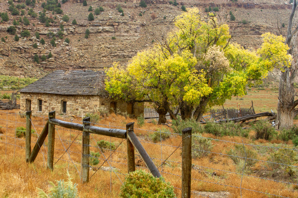
A few weeks ago it was raining when my wife and I started up the Nine Mile Canyon road from U.S. Hwy 6 in Wellington, Utah. I say "up the canyon" because the first part of the road to Nine Mile Canyon is correctly named Soldiers Creek Road and eventually climbs to 7,501 feet before descending into Nine Mile Canyon and the creek eventually flowing into the Green River.
By mile post 20 the rain became light, with low overcast and mountain obscurment. However the wet surfaces and diffused light presented unique lighting on several subjects. At mile post 23.5 the paved road accured a different character in its wetness which I thought made an interesting photo. At mile post 27.5 the collapsing barn of the old Don Johnstun homestead made an interesting photo with its wet wood and fall colors in the background. And my favoret picture of the day, the Dennis Winn Rock House built between 1884-1885 and was one of the first homesteads in Nine Mile Canyon.
By mile post 20 the rain became light, with low overcast and mountain obscurment. However the wet surfaces and diffused light presented unique lighting on several subjects. At mile post 23.5 the paved road accured a different character in its wetness which I thought made an interesting photo. At mile post 27.5 the collapsing barn of the old Don Johnstun homestead made an interesting photo with its wet wood and fall colors in the background. And my favoret picture of the day, the Dennis Winn Rock House built between 1884-1885 and was one of the first homesteads in Nine Mile Canyon.


Oct 12, 2021 13:23:50 #
Sep 22, 2021 14:43:17 #
The Henry Mountains south of Hanksville, Utah is home to a genetically pure, free roaming herd of buffalo. The total herd on the mountain is estimated at 300-400 animals. Over the years we have seen a few scattered buffalo. During a trip August 31 we were blessed with locating a herd of 80 to 100 buffalo at the 8,000 foot level on the west side of the mountain. It was an amazing sight to see that many buffalo passing through my field of view.

Aug 15, 2021 13:48:46 #
Impressive photos of some of the nations most impresive pictograph panels.
Ed
Ed
Aug 1, 2021 14:03:48 #
Fun to look at and the last shot really got my attention.
Great work, looking forward so seeing more. Ed
Great work, looking forward so seeing more. Ed
Aug 1, 2021 14:03:35 #
Fun to look at and the last shot really got my attention.
Great work, looking forward so seeing more. Ed
Great work, looking forward so seeing more. Ed
Aug 1, 2021 11:20:33 #
The airplane is an Ar Tractor AT-802 turboprop aerial application manufactured by the Air Tractor Inc. It was first flown in 1990 and is active production today. They also make a military version and a fire-fighting version.
Ed
Ed
Aug 1, 2021 10:50:03 #
I worked at the Seward Hospital as a lab and xray tech in 1969-70 and two of us shared that duty and we decided we would alternate time off on good weather days. Most of my photos do not reflect the typical environment of Reserrection Bay. But it was great fun and memories.Ed
Jul 19, 2021 10:59:11 #
Thanks for your comment and I am glad I shared it with you.
Ed
Ed
Jul 19, 2021 09:01:20 #
A recent post about bears in Alaska and someones comment that even domestic bulls can be dangerious brought the attached photo to mind. The picture was taken at a rodeo clown bull fight event. The young man was broused, but not seriously hurt. The photo was taken at an indoor arena, obviously at the edge of the action.

Jul 4, 2021 15:08:07 #
Sorry, it's only a yellow Jeep, but it is a more interesting picture than just stepping out of the tent trailer and photographing the rainbow. It is an easy example of making a picture than taking a picture.

Jul 2, 2021 11:19:33 #
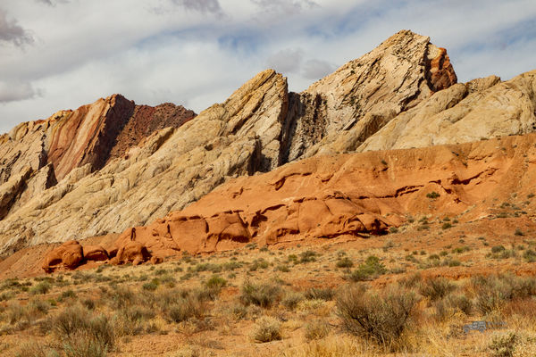
A long time ago in the creation of the earth forces deep below the surface pushed up a huge blister known today as the San Rafael Swell in south central Utah. The east edge of this uplift is dramatic with sandstone pushed up 800 to 1,000 feet at angles from 30 to 45 degrees from horizontal. This part of the "Swell" is known as the San Rafael Reef. As you travel west from the town of Green River, Utah the view and photo opportuities are incredible. On I-70, 13 miles west of Green River at milepost 147 graded dirt road access is provided north and south of the highway. On the south side, after passing through the closed, unlocked gate the road procedes for 6 miles along the "reef". The following photos were taken along that road.