Recommendations Eastern Sierra
Aug 9, 2016 10:58:33 #

CatMarley wrote:
You can leave your wheels at Whitney portals and take a hike to the summit. It is an easy climb on a well marked trail. Got to have good cardio-pulmonary function though because the altitude is over 14,000ft.
The 16 hour 22 mile trip to 14508 feet just about killed me twice and I'm in good shape!
I'm curious, when did you climb it? S-
Aug 9, 2016 11:02:03 #

CatMarley wrote:
You can leave your wheels at Whitney portals and take a hike to the summit. It is an easy climb on a well marked trail. Got to have good cardio-pulmonary function though because the altitude is over 14,000ft. But even if you don't get to the top, the photo ops are awesome and you can quit any time you like.
You have a 4wd, so don't be hesitant to take little side roads and explore. There are many little treasures to investigate. But watch your fuel and keep at least a half tank becuse I have been carried away exploring things and paid no attention, and spent 6 hours on a deserted desert track until rescued by an old mountain man and his fat dog in his ancient truck. Also carry lots of water and some food if you go exploring. It is a big desert.
Aug 9, 2016 11:49:54 #
St3v3M wrote:
The 16 hour 22 mile trip to 14508 feet just about killed me twice and I'm in good shape!
I'm curious, when did you climb it? S-
I'm curious, when did you climb it? S-
When I was 40. I was athletic as a kid, and in really good shape at 40. Also was aclimatized to altitude at that time. The trail is not difficult. And even if you don't get very far above the parking lot, the view is great. Lots of rocks to sit on and rest along the way. Also going down is easier than up.
Aug 9, 2016 11:57:28 #
CatMarley wrote:
When I was 40. I was athletic as a kid, and in really good shape at 40. Also was aclimatized to altitude at that time. The trail is not difficult. And even if you don't get very far above the parking lot, the view is great. Lots of rocks to sit on and rest along the way. Also going down is easier than up.
I was there a month ago and the trail is well used, well maintained, and the view is spectacular! S-
Aug 9, 2016 12:12:53 #
Aug 9, 2016 12:19:50 #
I have driven the eastern route from Palm Springs to Seattle many times and highly recommend it. One of the most unique sites is Mono Lake and you should be there before sunrise and sunset. It is very unusual and photographic.
Aug 9, 2016 13:47:58 #

You have a lot of great suggestions. I am surprised that on one mentioned Manzanar, a World War II Japanese Relocation Camp. It's on the west side of 395 between Lone Pine (a fascinating town) and Independence. It's now a National Historic Site and is a fascinating place to visit with plenty of unusual photo opportunities.
There is a lot to see along 395!
There is a lot to see along 395!
Aug 9, 2016 15:01:56 #

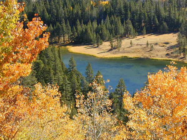
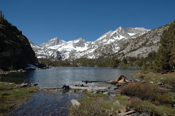
I used to live in the Eastern Sierra. It is a beautiful area most any time of year.
The fall colors will vary from year to year depending on the weather, but I would recommend early to mid October. My favorite location would be along Rock Creek Road from Toms Place to Mosquito Flats. Toms place is on US 395 24 miles north of Bishop, CA and is a great place to eat. http://www.tomsplaceresort.com/ You might give them a call to check on the status of the fall colors.
Mosquito Flats is the end of the road, and if you care to hike a mile or two up the trail you will will have some great photo-ops in Little Lakes Valley.
There are several Forest Service campgrounds along Rock Creek Road.
Aug 9, 2016 15:28:17 #
Aug 9, 2016 22:18:11 #
Now would be the time to get familiar with all the "fall color" camera web sites. The Fall Colors shift each year depending on climate changes recorded.
I use them for the Eastern Colors, and start watching them about a month before the forecasts.
You might do a search for Sierra mountain fall color camera's. I would think you will find a number of sites to put on your favorites by mountain ranged and general locales.
For instance I will do a search now called Sierra Mountain Range Fall Color cameras.
Take a peak at this one:
[url]http://www.desertusa.com/desert-activity/fall-color.html[/ulr]
Or this one:
http://renotahoe.about.com/od/newrenotahoeresidents/a/Fall-Color-Lake-Tahoe-Eastern-Sierra.htm
There are tons of these types of sited including government supported camera and forecast sites.
Keep looking. I don't know what area's you are interested in covering. These sites are often localized and in synch with each season.
Aug 10, 2016 11:18:33 #
Gerald Watson wrote:
Donot forget death valley.
I'm planning that for next Feb-March. Immense area that I don't have time for on this trip, but look forward to.
Aug 10, 2016 11:23:40 #
Pinenuts wrote:
I used to live in the Eastern Sierra. It is a bea... (show quote)
Tips that residents offer, former or current, are held in high regard. Nice pictures. Thanks.
Aug 10, 2016 16:50:53 #
CatMarley wrote:
When I was 40. I was athletic as a kid, and in really good shape at 40. Also was aclimatized to altitude at that time. The trail is not difficult. And even if you don't get very far above the parking lot, the view is great. Lots of rocks to sit on and rest along the way. Also going down is easier than up.
I'm still a kid way past 60, but I still think I'm 40. I do occasionally have that Uh-Oh! moment when pushing my capabilities, or when my wife asks, "Don't you remember?"
Aug 19, 2016 19:54:02 #

I was thinking of getting this book...
https://www.amazon.com/dp/1597143170/ref=wl_it_dp_o_pd_nS_ttl?_encoding=UTF8&colid=3LXQWP1JD3Z0Q&coliid=I1JP95QKSFN4WU
California's Fall Color: A Photographer's Guide to Autumn in the Sierra
by G Dan Mitchell (Author)
https://www.amazon.com/dp/1597143170/ref=wl_it_dp_o_pd_nS_ttl?_encoding=UTF8&colid=3LXQWP1JD3Z0Q&coliid=I1JP95QKSFN4WU
California's Fall Color: A Photographer's Guide to Autumn in the Sierra
by G Dan Mitchell (Author)
If you want to reply, then register here. Registration is free and your account is created instantly, so you can post right away.