Monument Valley, Utah question
Mar 26, 2016 10:38:19 #

Mar 26, 2016 10:49:44 #

philo wrote:
how far is Monument Valley from Arches?
It's going to be around 150 miles to get you from the northern part of Monument Valley to the Arches Nat'l Park. Figure a minimum of 3 hours.
Mar 26, 2016 10:53:12 #
Jandjcs wrote:
Great choice, photographers paradise. br Did it tw... (show quote)
GOOD POINT RE VALLEY OF THE GODS OUT OF MEXICAN HAT....IF YOU KEEP TAKING Road 261 a mile or so past the turnoff to Valley of the Gods, IT TURNS INTO A DIRT ROAD AND switchbacks straight up a massive cliff to get on top of an arm of a vast plateau where the pavement restarts and you can end up at Bridges National Park in about 35 or 40 minutes depending on how fast you are driving....
https://www.google.com/maps/place/Mexican+Hat,+UT/@37.2788958,-109.9722599,13z/data=!4m2!3m1!1s0x8737382cd502c16f:0xd834a571b3dc7f4d
Taking that Road 261 DOWN off the plateau into Mexican Hat driving by your Valley of the Gods at the bottom is one of the great road adventures of the American West...Just don't go fast..It is kind of a short cut between Monument Valley and Bridges but there is just this one leeeeeeeeeeeetle detail that must be negotiated.......one of the lesser known roads only 20 minutes north of Monument Valley...
On a map this segment is just a little but highly jagged/contorted squiggle..and that usually ain't a good sign on a map.. Switch to the satellite view of that same map and it is a whole different story.
If you are zipping eastbound on that plateau and have never been on 261, you have no suggestion what is about to happen either for the most part.......... and then the last mile or two you start to get the feeling you are out on an extended arm of what now is more and more looking like a plateau yet you are going 60 MPH....it starts feeling kind of like parts of Highway 12 in Utah just east of Escalante....not exactly but the theme of dropping off into an abyss starts entering your mind as if you had seen a version of this movie before...
But here on 261 you finally get to Judgment Day signified by huge warning signs etc... since the plateau ends and you think you can make out the Dallas, Texas skyline because now there is nothing at your level to the East but thin air except for this dirt road that plummets off the plateau down the cliff face in a series of switchbacks...which were those funny odd shaped squiggles you saw on the map and paused a second thinking.."now that's kind of odd..hmmm".
At least if you are coming from Mexican Hat you know exactly what is going to happen...it is right in front of you winding up the cliff...
check it out on Google Earth...
sorry for the typos
Mar 26, 2016 11:37:40 #
anyone want to join me on a road trip? Will be leaving Winnmacca Nv. about May 1 heading for Arches then south to Mount. valley then heading over to Las Vegas and then on to San Francisco. Will be gone about 3 weeks.
Mar 26, 2016 11:43:22 #
Take the advice and hire a native guide with a 4-wheel drive vehicle. They know the good spots and will get you there and back.I agree about Canyonlands and The Arches. If you have time, don't miss them. World class photo ops.
Mar 26, 2016 11:47:23 #

Hello,
We rented an SUV and drove ourselves around for miles and miles without any time restrictions and without a lot of people. Be very careful when you pull over to photograph, as people tend to get stuck in the sand....it almost happened to us.
You'll have a great time. Make sure you post your work.
Enjoy!!!
Mar 26, 2016 12:12:12 #
Amielee
Loc: Eastern Washington State
The B-52s were out of Fairchild AFB in Spokane, WA. The low altitude training routes were called "Olive branch routes". And at the time I worked in ICU at a local hospital. I remember the crash well. We did not get any of the airmen but the wife of one worked there. :)
Mar 26, 2016 12:20:06 #
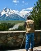
Just north of Monument Valley and Mexican Hat, there are two great photography sites. One is Gooseneck State Park where wide angle lens and/or panoramic shots are a must. Second, go on north and drive up the Moki Dugway. Right at the top you turn left or west to get to Muley Point. Great views of Monument Valley and the goosenecks on the San Juan River as it heads for Lke Powell. Also, if you hike, take the trail out to where the Thumbs are in Monument Valley. Early morning is a great time to hike in Monument Valley. Enjoy God's Country!
Mar 26, 2016 13:26:51 #

NorthPacific wrote:
GOOD POINT RE VALLEY OF THE GODS OUT OF MEXICAN HA... (show quote)
Yes, I'll never forget when I drove this awesome road about 30 years ago on a sunny but cold January morning.
I'm not sure if this has changed but back then it was just a rutted dirt road. I had to go very slow driving up the switchbacks because every time I sped up a little the car was bouncing precariously towards the edge of the the steep cliff!
When we reached the top of the plateau a snowplow driver waved us down gesturing for us to stop. He then asked if we had encountered any snow or ice in the switchbacks and when told him no he said: "Oh Thank God I don't have to drive down there!"
In general, the Four Corners Area, Monument Valley, Arches and Canyonland Parks are truly God's country and should be items on everyone's bucket list...especially for a photographer!
Mar 26, 2016 14:12:54 #

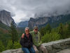
I loved Valley of the Gods also. Son and I got there 7am no one else around. Here is a few Pics, well worth the 30 minute trip from Monument Valley


Mar 26, 2016 14:24:25 #

Trying to find prices for the View Hotel.
No rates on their website.
Thanks.
No rates on their website.
Thanks.
Mar 26, 2016 15:50:18 #
there is a good book on the whole 4 corners area called The Complete Guide The Four Corners Region Where Colorado;Utah;Arizona & New Mexico Meet.by Sara J.Benson. IT covers the history;lodging;dinning;culture;recreation;shopping;transportation & more.ITs a great book for anyone who is planning a trip to this area.I picked it up from Edward R.Hamilton Bookseller company which is where I buy a lot of my books and DVDs on sale. the websight is www.Hamiltonbook.com IF you are looking for books or travel dvds at a great price check this website out you wont be disappointed.
Mar 26, 2016 16:03:12 #

The View is the best place to stay as mentioned previously. Hard to take a bad photo there.
Bring plenty of film.
Bring plenty of film.

Mar 26, 2016 16:05:33 #

Rich Maher wrote:
Trying to find prices for the View Hotel.
No rates on their website.
Thanks.
No rates on their website.
Thanks.
You may have to click on 'Check Availability' and enter a date. It should show you the cabins or hotel rooms and rates. We have reservations for the lodge in October. Lou
Mar 26, 2016 16:08:52 #
If you want to reply, then register here. Registration is free and your account is created instantly, so you can post right away.