Advice on Road Trip — Thanks
May 24, 2022 13:11:11 #
May 24, 2022 13:11:40 #
Mr Bill 2011
Loc: southern Indiana
Ronsh wrote:
A road trip from San Antonio, Tx to Glacier National Park then to Portland,Or. looking for places to stop and shot wildlife and landscape. Any hidden places would be great. No long hikes. Then Portland down to north rim GCNP and the arch’s area
Thank y’all
Ron
Thank y’all
Ron
how much time do you have? What are you driving? Just looking at a Rand McNally Road Atlas you could make a nice loop going thru Denver, RMNP, west to Dinosaur Natl.Mon., then up thru the Tetons, Yellowstone, to Glacier. Return via Portland to the Oregon coast, then south along the coast, inland to Crater Lake, down along the Sierras to Reno and Lake Tahoe, east on US 50 to Lehman Cave, Great Basin NP, to Bryce Canyon NP, then south to GCNP North Rim. Then thru Monument Valley to Canyonlands and Arches, east to Mesa Verde NP, Taos, Santa Fe, White Sands NP, Carlsbad Caverns NP, then home. So many nice places you should see; I've been to all except Taos, White Sands, and Carlsbad, and all are worth the time it takes to visit. Shouldn't take more than a couple months and $10k for gasoline.
May 24, 2022 13:12:56 #
Ronsh
Loc: Floresville,Tx.
DLewis wrote:
From Denver, go to Golden, CO and then Highway 93 North a couple of miles to Golden Gate Canyon road. Golden Gate Canyon to Highway 119 (Peak To Peak Highway) to Estes Park, CO. From Estes Park, go to RMNP and take the dirt Fall River Road to the top of Trail Ridge Road. Easily done in a car. Far more beautiful than the paved road to the top.
About half way up Golden Gate Canyon, stop at the Visitor Center and see the pond loaded with huge trout.
Dennis
About half way up Golden Gate Canyon, stop at the Visitor Center and see the pond loaded with huge trout.
Dennis
DENNIS , will do for sure thanks for the information.
Ron
May 24, 2022 13:19:56 #
Ronsh
Loc: Floresville,Tx.
Mr Bill 2011 wrote:
how much time do you have? What are you driving? ... (show quote)
Mr. Bill you are right about the time & $, our son getting married on 9 jun we are leaving this week hopefully! Thanks for the information, ya got to get a road atlas for sure we will be driving a Toyota Rave 4. Only plan to drive about 6 hrs a day and have as much fun as two 70 year olds can.
Ron
May 24, 2022 13:26:52 #
Mr Bill 2011
Loc: southern Indiana
Ronsh wrote:
Mr. Bill you are right about the time & $, our son getting married on 9 jun we are leaving this week hopefully! Thanks for the information, ya got to get a road atlas for sure we will be driving a Toyota Rave 4. Only plan to drive about 6 hrs a day and have as much fun as two 70 year olds can.
Ron
Ron
I especially recommend Bryce, GCNP, Monument Valley, Canyonlands, Arches, and Mesa Verde. Good thing is they are all close to each other and in a row.
May 24, 2022 13:32:27 #
May 24, 2022 13:52:36 #

May 24, 2022 13:53:33 #
May 24, 2022 14:03:49 #
May 24, 2022 14:04:44 #
Ronsh wrote:
Awesome photos, they will be on the list for sure.
Thank you
Ron
Thank you
Ron
You are welcome, Cheers

May 24, 2022 14:07:16 #
photoman022
Loc: Manchester CT USA
I suggest that you write to every state that you'll travel through and ask for a free road map (I got the addresses off of the internet). I took two road trips from Connecticut to California (and back) and I used the road maps (as opposed to an atlas) to plot my trips. My goal was to stay off of interstate as much as possible (except for big cities). I was astounded by the photographic opportunities afforded along the way. I did notice that the photographic opportunities expanded exponentially once I hit central Kansas! By staying off the interstate I was able to pass through Chivington, Colorado, near the Sand Creek Massacre National Historic Site. Col. Chivington commanded the Colorado militia that perpetrated the massacre on the "peace Indians" (who had signed peace treaties with the US Government. The "back road" I traveled had wide shoulders for pulling over and photographing interesting sites -- something I would never do on the interstate!
May 24, 2022 14:09:51 #
A couple more from Lower Antelope Canyon, Navajo Lands, Page, Arizona.
Upper and Lower Antelope Canyon are accessible by Navajo Guided tours only.
Here is a link to the original and still best Lower Antelope Canyon Navajo Guides, "Ken's"
https://www.lowerantelope.com/
Cheers
Upper and Lower Antelope Canyon are accessible by Navajo Guided tours only.
Here is a link to the original and still best Lower Antelope Canyon Navajo Guides, "Ken's"
https://www.lowerantelope.com/
Cheers


May 24, 2022 14:20:53 #

Ronsh wrote:
The most direct route from San Antonia, TX to Portland, OR is about 2100 miles. At an average 50mph for 6 hours a day, that would require a week's driving. "This week" ends on Saturday, 28 May, and that would give you about 11 days before the 9th of June. The direct route goes right through Moab, UT and Arches and Canyonlands NPs are close by--would you want to visit them on the way to Portland? The only other notable places along that route are Albuquerque, NM and Salt Lake City, UT. The Sandia Peak Tramway (sky ride) is an enjoyable photographic experience (Albuquerque).Mr. Bill you are right about the time & $, our son getting married on 9 jun we are leaving this week hopefully! Thanks for the information, ya got to get a road atlas for sure we will be driving a Toyota Rave 4. Only plan to drive about 6 hrs a day and have as much fun as two 70 year olds can.
Ron
Ron
I've built a new map that takes the direct route to Portland, with optional stops at Arches and Canyonlands NPs at Moab, UT. From Portland it goes to the west entrance of Glacier NP; Yellowstone NP; Grand Teton NP; Page, AZ (Glen Canyon Dam, Lake Powell, Antelope Valley, Horseshoe Bend); to the North Rim of the Grand Canyou; Sedona, AZ (red rocks), and home.
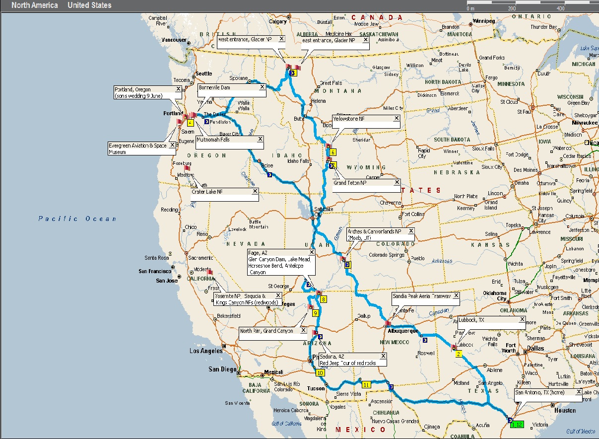 UHH map7 by David Casteel, on Flickr
It's a total of about 5400 miles, which at 300 miles/day (6 hours at average 50mph) would take a total of 18 days driving--figure 3 weeks with stops.
FWIW, Kanab, UT is on the route, just before Page, AZ. (see next post)
May 24, 2022 14:34:00 #

Ronsh wrote:
A road trip from San Antonio, Tx to Glacier National Park then to Portland,Or. looking for places to stop and shot wildlife and landscape. Any hidden places would be great. No long hikes. Then Portland down to north rim GCNP and the arch’s area
Thank y’all
Ron
Thank y’all
Ron
For the area from Santa Fe, NM in the east to St. George, UT in the west, and from Price, UT in the north to Sedona, AZ in the south, consult "Hiking [the] Southwest Canyon Country by Sandra Hinchman.
I know you said no long hikes, so you can skip the several day hike she describes wading up to your chest going down the Paria River - I certainly have. But she also describes lovely tours to take in your car, and tiny strolls, and ten, twenty, and thirty minute hikes, and just about all the sights to be seen in those spectacular parts of the country. I know she doesn't hit everything, but she does come close.
One item she doesn't mention is the Rocking V Cafe, in Kanab, UT. If you find yourself in that neck of the desert, I heartily recommend that you stop by.
May 24, 2022 15:21:45 #

gwilliams6 wrote:
A couple more from Lower Antelope Canyon, Navajo Lands, Page, Arizona.
Upper and Lower Antelope Canyon are accessible by Navajo Guided tours only.
Here is a link to the original and still best Lower Antelope Canyon Navajo Guides, "Ken's"
https://www.lowerantelope.com/
Cheers
Upper and Lower Antelope Canyon are accessible by Navajo Guided tours only.
Here is a link to the original and still best Lower Antelope Canyon Navajo Guides, "Ken's"
https://www.lowerantelope.com/
Cheers
Love the magnificent light, lines, and abstract quality 🏆🏆🏆🏆🏆
If you want to reply, then register here. Registration is free and your account is created instantly, so you can post right away.