Recommended Excursions near the Million Dollar Highway?
Oct 9, 2023 14:58:59 #
I am planning a few days drive long the “million dollar highway” (US 550) soon to photograph fall colors. I’ve been on this highway before so know that there are many scenic pullouts. We will be going from (start) Durango - Silverton - Ouray - Ridgeway, then CO62 to Telluride. Probably will make a big loop and come back to Durango via CO 145, then CO 145 to Dolores, then 184/ 160 back to Durango.
Question for anyone very familiar with this area - are there any recommendations for places to visit with beautiful scenes that are off the path (a little) from these main roads? I will have an all-wheel drive Telluride, but it’s not super high, and is ok on dirt/gravel roads but not good for serious off road trails (It's not a jeep).
Question for anyone very familiar with this area - are there any recommendations for places to visit with beautiful scenes that are off the path (a little) from these main roads? I will have an all-wheel drive Telluride, but it’s not super high, and is ok on dirt/gravel roads but not good for serious off road trails (It's not a jeep).
Oct 9, 2023 16:12:24 #
David283
Loc: Duluth,GA
My wife and me spent 3 weeks in a rental car going all over on many gravel roads and we did not have any problems.
Oct 9, 2023 16:17:18 #

Ophir Pass, a few miles north of Silverton on Hwy.550. Last Dollar Rd from Telluride to Ridgway. Owl Creek Pass by Delta. Molas Lake on Hwy 550 just south of Silverton.
Oct 9, 2023 16:59:06 #
cliff Hilbert wrote:
Ophir Pass, a few miles north of Silverton on Hwy.550. Last Dollar Rd from Telluride to Ridgway. Owl Creek Pass by Delta. Molas Lake on Hwy 550 just south of Silverton.
Thanks - Did a little research on Last Dollar Road. Will probably do that, but from Ridgeway to Telluride. Molas lake looks very doable. Owl Creek Pass might be a bit too far off our planned trek, but we'll see.
Oct 9, 2023 19:12:14 #
Here's a picture of Molas Lake I took two weeks ago when I was up there.
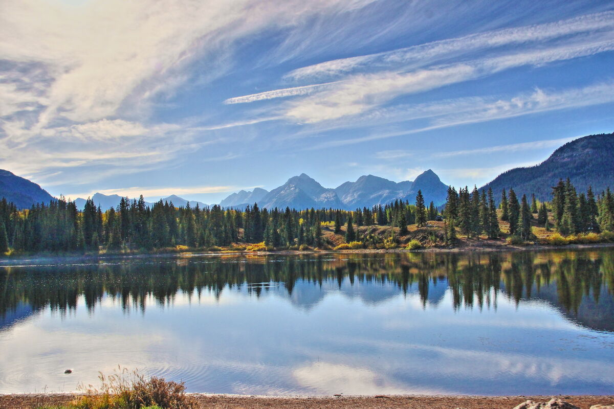
Oct 9, 2023 19:17:48 #
Check these out from Beth who lives in Southwestern Colo. #4 and #5 are from Ophir Pass. I think #2 and #3 are also from Ophir Pass. She took a week ago.
https://www.uglyhedgehog.com/t-788627-1.html#14208478
https://www.uglyhedgehog.com/t-788627-1.html#14208478
Oct 9, 2023 19:51:24 #
Oct 9, 2023 20:52:59 #

Oct 10, 2023 17:23:14 #

cliff Hilbert wrote:
Here's a picture of Molas Lake I took two weeks ago when I was up there.
OMG
 Stunningly beautiful scenic shot 🏆🏆🏆🏆🏆
Oct 11, 2023 09:34:17 #
CliffMcKenzie
Loc: Lake Athens Texas
cliff Hilbert wrote:
Was just at Ophir Pass. When Jeeps are reducing their 33\35 inch tires to 50% pressure...I would not try it. The sign at the opening makes it clear. Cliff, just sent you a private message.Ophir Pass, a few miles north of Silverton on Hwy.550.
Oct 11, 2023 10:09:52 #
CliffMcKenzie
Loc: Lake Athens Texas
Basil wrote:
I am planning a few days drive long the “million dollar highway” (US 550) soon to photograph fall colors. I’ve been on this highway before so know that there are many scenic pullouts. We will be going from (start) Durango - Silverton - Ouray - Ridgeway, then CO62 to Telluride. Probably will make a big loop and come back to Durango via CO 145, then CO 145 to Dolores, then 184/ 160 back to Durango.
Basil, literally, just did this exact pass. After 6 days moving up from Ghost Ranch \ NM (too early for the Aspen), Sept 29 \ Oct 4 was Durango to Silverton to Ouray to Ridgeway to Telluride to Ophir to Durango. Slight variations of Sliverton to Alpine Pass and off roading between Ridgeway and Telluride. My mission was to capture the Aspen brilliant yellow and the rare time when red color starts to appear. It was a success. The trees started changing in route to Silverton. Go through Silverton (great BBQ at Thee Pit) to the East a little distance.
The Million Dollar Highway next, worth it, plan a lot of stop, take images and start time. I really liked Ouray, great grocery store (only one) and plan to refuel in Ridgeway.
When you go to Ridgeway, go up Hwy 17, it runs parallel to the major road. When you are in Ridgeway, seek out John Wayne's restaurant. I had a lot of fun in this area. Send me a private message and I will find a 4-wheel rental company map showing where to go and not go a friend gave me.
Telluride is great with a lot of shots taken in and around the city. Here you get the Aspen all in yellow surrounded by beautiful pines. Ophir was the end of the shoot. It also begged the question, was I here to shoot or 4-wheel, with that, Durango then to Las Cruces where I suffered total brake failure. It appears my customized FJ Cruiser with armor plating does not include brake line connection protection.
Hope this helps, Cliff
Oct 11, 2023 11:36:53 #
CliffMcKenzie wrote:
Basil, literally, just did this exact pass. After... (show quote)
Yeah, that sounds pretty much like the trek I'm hoping to do (except for the Ophir part, if roads are as bad as you say). I actually did this same trip last year around this same time. The colors were spectacular and I'm hopeful they are not too much past peak for this trip. According to an online foliage estimator map, the colors should be at or near peak for a lot of the area, but maybe a little past peak in the areas from Durango to Silverton. Fingers crossed.
I'm sorry to hear about your brake failure - that could have been a disaster - glad you're still around to post about it!
My car is a Kia Telluride (appropriate for where I'm going, eh?). It has AWD capability and does pretty good in semi-rough roads, but it's not what you'd call an "off-road" vehicle. It's certainly not going to keep up with a jeep. So let me ask you about the Ophir pass road. You indicated there were some pretty rough parts. If you did the entire stretch from Colorado highway 145, to Ophir, then to US 550 (million dollar highway). Where was the "bad" part? Was it from the stretch from Telluride (145) to Ophir, or was it the stretch between Ophir and US 550? I guess specifically I'm wondering how the stretch east of Ophir (from 550 to Ophir) was? We would be coming up 550 from Durango to Silverton, and if the stretch from there to Ophir wasn't too bad, I might want to take that pass to Ophir, but then turn around and go back to 550.
Oct 12, 2023 13:01:47 #
CliffMcKenzie
Loc: Lake Athens Texas
Basil wrote:
Yeah, that sounds pretty much like the trek I'm ho... (show quote)
Basil, sent you a private message with map this morning.
"Durango to Silverton. Fingers crossed." [[]] Interesting, but they were way behind last week until you almost reach Silverton.
"If you did the entire stretch from Colorado highway 145, to Ophir, then to US 550 (million dollar highway)." [[]] This was not my route. When I finished Ophir, it was on to Dolores\Durango. You can cross from Ophir to Old Ophir to 550, but I have not heard anyone doing it. The reason may be this is true level 4\5 roads and the dream of those 4-wheeling. My mission was images and the images were light in the area. You can also cross over to Ouray to Telluride via Imogene Pass but again you need high ground clearance.
Since all of this is my first time, I was very happy to take Durango to Silverton to Ouray to Ridgeway (played in the MTNs) to Telluride to Ophir to Durango (3 days).
Hope this helps, by the way National Geographic has a map named Telluride, Silverton, Ouray, Lake City - got it from Amazon.
Cliff
If you want to reply, then register here. Registration is free and your account is created instantly, so you can post right away.