Old 1940-1941 Photographs Alone The Eastern Sierras, CA
Aug 4, 2015 02:14:40 #

Earlier this evening I was looking thru a small suite case that I keep some of my deceased Father's personal things in, like old photographs, clippings, badges and pins. He lived from 1922-2006. I came across a few old photos that I found interesting because I had visited the two locations myself decades later around 2013.
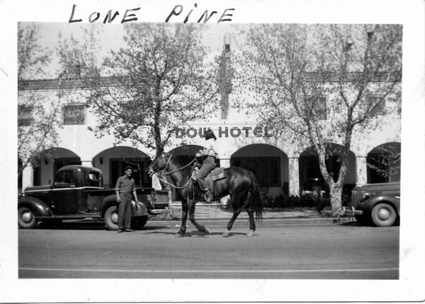
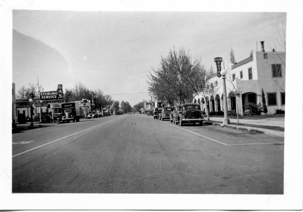
The photographer is unknown, though my father might have taken them, or one of his buddies. Two of the photos show the Dow Hotel (now Hotel Dow Villa), Main Street (US 395), Lone Pine, California. My wife and I stayed at the Dow in 2013(?) while on a photography vacation along Highway US 395. My guess the photos were taken around 1940-41. It had to have been while he was in the Civilian Conservation Corps (CCC) from about 1938-1941, but before 1942 as he enlisted in the Navy right after December 7, 1941. Also the automobiles in the photos look like 1939-1941 models.
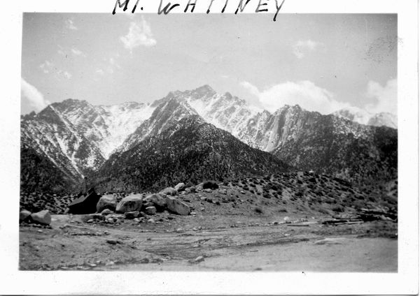
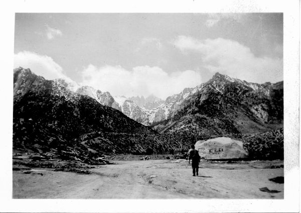
The second pair of photos like the first my Dad may have taken, I don't know. They would have been from the same time period and relatively close in proximity. These depict the vicinity of Mount Whitney, CA.
Here I would like to ask other UHH members for some help. Do any of you recognize the actual locations where these two images of Mount Whitney where shot from? The East side or the West side, Alabama Hills, Whitney Portal, Diamond Mesa, etc. If we have any California back country photography trekkers please give the two photos a look. They don't look like any that I shot during two trips to the area over the last five years. I am really curious. Thank you.
- Mike
The photographer is unknown, though my father might have taken them, or one of his buddies. Two of the photos show the Dow Hotel (now Hotel Dow Villa), Main Street (US 395), Lone Pine, California. My wife and I stayed at the Dow in 2013(?) while on a photography vacation along Highway US 395. My guess the photos were taken around 1940-41. It had to have been while he was in the Civilian Conservation Corps (CCC) from about 1938-1941, but before 1942 as he enlisted in the Navy right after December 7, 1941. Also the automobiles in the photos look like 1939-1941 models.
The second pair of photos like the first my Dad may have taken, I don't know. They would have been from the same time period and relatively close in proximity. These depict the vicinity of Mount Whitney, CA.
Here I would like to ask other UHH members for some help. Do any of you recognize the actual locations where these two images of Mount Whitney where shot from? The East side or the West side, Alabama Hills, Whitney Portal, Diamond Mesa, etc. If we have any California back country photography trekkers please give the two photos a look. They don't look like any that I shot during two trips to the area over the last five years. I am really curious. Thank you.
- Mike
Dow Hotel, Lone Pine, CA. ca 1940-41?
(Download)
Dow Hotel, Lone Pine, CA, along Main St. (US 395). ca 1940-41?
(Download)
Mount Whitney, CA 1940-41?
(Download)
Mount Whitney, CA 1940-41?
(Download)
Aug 5, 2015 11:42:28 #

Great find of some photos from much simpler and, for many, happier times. My grandparents too several driving vacations from the Midwest (Kansas) to the West Coast and these scenes are similar to what they saw.
Be sure to keep these safe!
Tom
Be sure to keep these safe!
Tom
Aug 5, 2015 16:57:18 #
lamiaceae wrote:
Earlier this evening I was looking thru a small su... (show quote)
My memories are old and vague but I spent a lot of time in this area back in the late 70s.
I think your 2 shots were taken fairly close together on the east side looking west. The route was probably west from Lone Pine on the old Whitney Portal road.
There are/were many drivable dirt roads that come and go with the seasons so it may be impossible to know exactly where this was at.
Here is a site for climbers I found with some photos.
http://timberlinetrails.net/WhitneyAerialPhoto1.html
The first aerial image has most of the same landmarks as the one you posted marked Mt. Whitney.
Obviously yours was taken from ground level but I think you can get an idea from this.
Hope this helps.
Aug 5, 2015 22:31:04 #
BBurns wrote:
My memories are old and vague but I spent a lot of... (show quote)
Thank you BBurns,
Your link is quite interesting. I'll have to study the aerial images closely to see if I can match points to my images. I've been in the area twice during the period of around 2010-2014. Yes, they were taken really close together but the exposures being different (location and time could separate them as well), even with considerable over lap I would not be able to make a stitched panorama from them. Your suggestion of a location makes sense. Yes, very likely from the Whitney Portal Road. I was not sure if perhaps they were taken from the West side of the peaks. Like I said I've driven thru the Alabama Hills and on the Whitney Portal Road. And yes with a friend in another vehicle we got rather lost on the dirt roads running throughout the hills, valley and plain in the area.
You may know that the entire area of the Alabama Hills and Lone Pine, CA with the back drop of the Sierra Nevada Mountains has been used as the setting of many films for close to a century. A good number of old Westerns and more recently, Science Fiction have scenes shot in-town and among the usual rock formations. Including Robert Downey Jr. posing as "Tony Stark" in front of Mt. Whitney in Iron Man (I). There is an interesting local motion picture museum in Lone Pine today.
My Dad was in the CCC's I believe from around 1938-1941 and worked in many states on various projects. He spent some time in California. Oddly he never really grew to like the desert, I really love the desert, especially for photography, just not the heat and cold. Again thanks for your help. I am going to take another look through these old photos and see if there are other goodies I've missed before.
Mike
If you want to reply, then register here. Registration is free and your account is created instantly, so you can post right away.