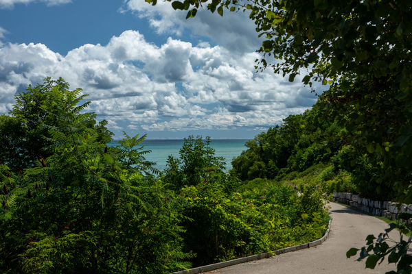
Lake Michigan, west coast, northern Milwaukee County, late August.
Aug 23, 2019 23:34:31 #
Ed Hannan
Loc: Greendale, WI
Upon rounding the last curve, the road ended abruptly! And all piers to the ferry were submerged!
Aug 23, 2019 23:48:41 #

Aug 24, 2019 00:27:30 #
UniqueShot
Loc: Eugene, OR
There's got to be some history here - inquiring minds what to know..... oh, the last curve photo, nice.
Aug 24, 2019 09:46:37 #


Aug 24, 2019 09:55:08 #

Aug 24, 2019 11:03:19 #
Ed Hannan
Loc: Greendale, WI
Just imagined a story to fit the scenes. The cloud formations and the water's hue caught my eye.
I forgot to mention the details. All photos were shot with a Canon, evaluative metering, using Canon's L-Series 1:2.8 EF 24-70mm and a circular polarizing filter.
Photo 1: f/11.0, 1/100, ISO 100
Photos 2 & 3: f/9.0, 1/400, ISO 200
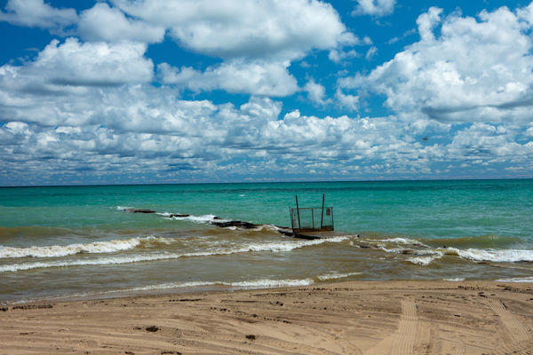
In photo 2, a small black spot hovers at about 45 degrees above the right fence post. That's a bumblebee moseying past. I've tried to remove it using Photoshop's eye dropper tool and the spot healing brush tool. I've followed the online tutorials, but I couldn't get either to work. Any suggestions?
I forgot to mention the details. All photos were shot with a Canon, evaluative metering, using Canon's L-Series 1:2.8 EF 24-70mm and a circular polarizing filter.
Photo 1: f/11.0, 1/100, ISO 100
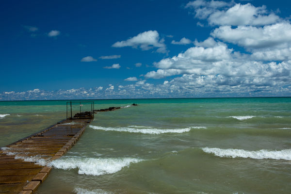
Photos 2 & 3: f/9.0, 1/400, ISO 200
In photo 2, a small black spot hovers at about 45 degrees above the right fence post. That's a bumblebee moseying past. I've tried to remove it using Photoshop's eye dropper tool and the spot healing brush tool. I've followed the online tutorials, but I couldn't get either to work. Any suggestions?
Aug 24, 2019 14:11:20 #

I produced the following using Lightroom's Clone tool.

Aug 24, 2019 14:59:22 #

Atwater Beach (aka Gorky Park when the Russians first came to the Shorewood area)?
Aug 24, 2019 15:05:53 #

Ed Hannan wrote:
Upon rounding the last curve, the road ended abruptly! And all piers to the ferry were submerged!
Beautiful images Ed.
Aug 24, 2019 19:40:49 #
Ed Hannan
Loc: Greendale, WI
I'm unsure of Atwater Park & Beach's history. It is one of the best parks on the shore of Lake Michigan. It's managed by the Village of Shorewood, not by Milwaukee County. I do not know of any Russian, Ukrainen, Georgian, Polish or any expatriat former citizens of any of the Balkan countries who ever resided in Shorewood. (Our youngest son, now 32, just returned from Kiv, Ukraine (that's how "Kiev" is spelled in the Ukraine) visiting his best friend whom he's known since 2nd grade. His friend's sister and parents resided in Greendale, WI, a village on Milwaukee County's far southwest side, where several families from Georgia (on the Black Sea) reside.)
Aug 24, 2019 19:42:16 #
Ed Hannan
Loc: Greendale, WI
Thanks to all and to Dave in particular for pointing me to Lightroom's cloning tool.
Ed Hannan
Ed Hannan
Aug 24, 2019 20:42:03 #

Nice pics, very rich colors.
FWIW, Lakes Michigan and Huron are at very high levels this year due to precipitation.
In my 65 years I have never seen Lake Michigan this high and I spend a lot of time in Ludington every year.
FWIW, Lakes Michigan and Huron are at very high levels this year due to precipitation.
In my 65 years I have never seen Lake Michigan this high and I spend a lot of time in Ludington every year.
Aug 24, 2019 22:31:29 #
Ed Hannan
Loc: Greendale, WI
Not to worry. We've got a long way to go.
Changes in climate (as opposed to “weather”) have followed a regular pattern for the past 700,000 years, with each cycle lasting about 100,000 years consisting of a long period of generally cooling climate during which glaciers grow, followed by shorter periods of temperatures similar to or warmer than those existing today. During the Wisconsin Glacial Episode the ice sheet was extremely thick – 4.48 km, or 13,123 feet, or 4.48 miles above Wisconsin Avenue in Milwaukee.
The "lowest" monthly average lake level for Lakes Michigan and Huron (which are connected hydraulically at the Mackinac straits), 576.02 feet IGLD 1985 (“International Great Lakes Datum), occurred in January 2013. The "highest" monthly average lake level for the network of gages on Lake Michigan/Huron, 582.35 feet IGLD 1985, occurred in October 1986. This is a difference of 6.33 feet in water level elevation since records have been kept. The all-time "highest monthly average" lake level for a gage station, 582.64 feet IGLD 1985, occurred on Lake Huron at the Harbor Beach, Michigan gage in June 1886.
Call me a troglodytic heretic and dispatch the breathless hoard bearing torches, pitchforks, and ropes, but ...
Aug 24, 2019 22:50:31 #
Sorry bout that Ed, I didn’t mean to imply anything was extraordinary, but as you so well point out, the lakes are very dynamic.
Aug 24, 2019 23:02:43 #
Ed Hannan
Loc: Greendale, WI
No insult taken, and I did not intend any. Just passing on historical data confirming that the current Lake Michigan level is relatively modest when assessed against that data. (My last comment was intended to be humorous. I see that it is a touch "dark.")
Thank you for your kind comments.
Thank you for your kind comments.
If you want to reply, then register here. Registration is free and your account is created instantly, so you can post right away.