Geotagging Photos with Android Phone + Adobe Lightroom CC 7.5
Aug 25, 2018 11:03:08 #

Found a real easy way to put GPS coordinates in photos so they show up on a map.
If you have an Android phone there is an app called "ULTRA GPS LOGGER" on the Google Play Store for $5.99.
Make sure your camera and phone clock match then simply start the app and start logging.
Take all the photos you want all day long.
As long as the app is running it is monitoring your phones every position.
This app can create 4 different files. NMEA KML GPX CSV.
For our purpose here we want the GPX file.
When you get home, transfer the GPX file to your PC. Transfer your photos to the PC.
Using Adobe Lightroom import your photos into Lightroom. Go to Map and import the GPX file. Select all the photos on the bottom and select geotag photos.
Now all your photos are branded with GPS Coordinates and will show on the map where they were taken. Location accuracy depends on your phones GPS.
Now that I know how to do this I can Geotag all my photos in a matter of minutes.
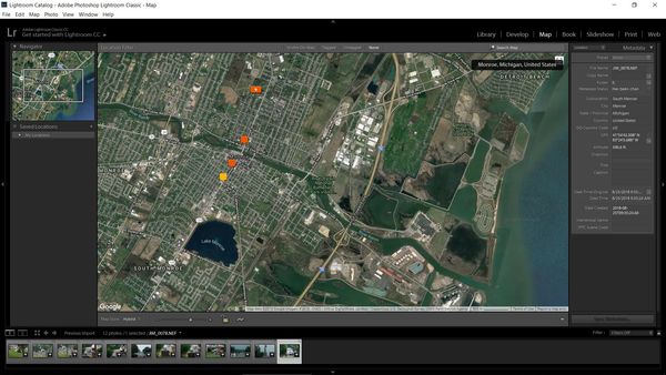
*** The attached photo is a sample of what Lightroom map looks like displaying Geotagged photos. ***
Here are the instructions for Lightroom ----> https://www.youtube.com/watch?v=CWQCiLFgFrs
Here is the APP ----> https://play.google.com/store/apps/details?id=com.flashlight.ultra.gps.logger&hl=en_US
If you have an Android phone there is an app called "ULTRA GPS LOGGER" on the Google Play Store for $5.99.
Make sure your camera and phone clock match then simply start the app and start logging.
Take all the photos you want all day long.
As long as the app is running it is monitoring your phones every position.
This app can create 4 different files. NMEA KML GPX CSV.
For our purpose here we want the GPX file.
When you get home, transfer the GPX file to your PC. Transfer your photos to the PC.
Using Adobe Lightroom import your photos into Lightroom. Go to Map and import the GPX file. Select all the photos on the bottom and select geotag photos.
Now all your photos are branded with GPS Coordinates and will show on the map where they were taken. Location accuracy depends on your phones GPS.
Now that I know how to do this I can Geotag all my photos in a matter of minutes.
*** The attached photo is a sample of what Lightroom map looks like displaying Geotagged photos. ***
Here are the instructions for Lightroom ----> https://www.youtube.com/watch?v=CWQCiLFgFrs
Here is the APP ----> https://play.google.com/store/apps/details?id=com.flashlight.ultra.gps.logger&hl=en_US
If you want to reply, then register here. Registration is free and your account is created instantly, so you can post right away.