app to create electronic album of a road trip with an actual map showing the route
Aug 14, 2018 16:07:09 #
Aug 14, 2018 16:42:07 #
I use a Sony action cam, XFDR-3000, if you let it, it puts a GPS map in the corner of everything.
Aug 14, 2018 17:21:16 #
Aug 14, 2018 18:00:51 #
Aug 14, 2018 18:15:25 #
If you want one pic/one map location and for display in something like a digital frame, you could create your own 
Aug 15, 2018 09:40:13 #
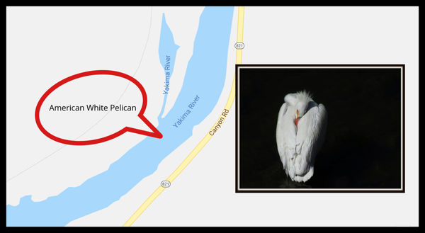
We use SmugMug to create the album. I download route maps (A to B to C etc) in PDF from Google Maps and add these to the album with details in the caption or added to the map. You can put the maps in the sequence as appropriate. A few times I’ve saved large scale map images and added sight lines and or other markers to show a picture’s perspective or ID things. You can also use this technique to indicate perspective or specific details on landscapes.
Aug 15, 2018 10:02:55 #

If you want to reply, then register here. Registration is free and your account is created instantly, so you can post right away.