Reading a USGS survey marker
Mar 5, 2012 11:43:12 #

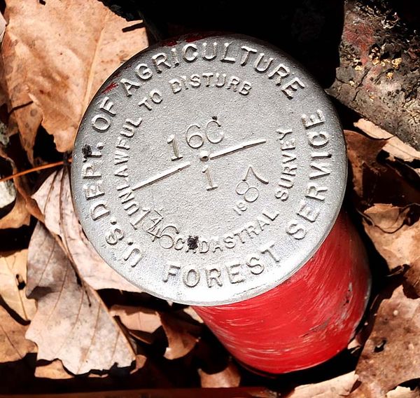
Anybody know how to read a USDA Forest Service survey marker?
I figured out that it was placed in 1987. What is the 1346? It is NOT the elevation, it is much higher there than that. What is the 16C over 1 and the lines and dot that separate them?
Any help would be appreciated.
Thanks,
The marker is below.
Eric
I figured out that it was placed in 1987. What is the 1346? It is NOT the elevation, it is much higher there than that. What is the 16C over 1 and the lines and dot that separate them?
Any help would be appreciated.
Thanks,
The marker is below.
Eric
Mar 5, 2012 14:48:28 #
Mar 5, 2012 14:55:57 #
snowbear wrote:
What county & state is it located in?
The marker is located on Buffalo Mountain; Washington County, TN.
Eric
Mar 5, 2012 15:16:13 #
It's a survey boundary marker so it doesn't designate elevation. There are different typed of survey markers with different symbols in the middle.
Obviously, it has to do with the Forestry Service - probably USFS lands. If I find anything I'll let you know.
I'm looking for a database that would have the numbers listed - not much luck, so far. Unfortunately, my GIS/Cartography classes did not cover these that much - probably if I went into surveying.
Mar 5, 2012 19:25:26 #
Mar 5, 2012 19:48:37 #
MT Shooter wrote:
Have you asked a Ranger? They are usually quite helpful.
Not yet, the closest Ranger Station is farther than the hiking trail. The next time I get by there...
Thanks for the suggestion,
Eric
Mar 5, 2012 22:46:29 #

Went to cadastral survey, under BMI. They explain with pic's llike yours...It's a boundrey marker
Mar 6, 2012 07:02:39 #

I agree on this being a boundary marker. And the symbols are on the map that goes with the area. Just like the old road maps that we use to have. If you remember those, numbers down one side and letters running along the other.
Erv
Erv
Mar 6, 2012 07:20:12 #

Mar 6, 2012 11:06:42 #
The USGS site has info on the "how-to" of locating the markers and becoming a "marker sleuth" - may help.
http://www.mountainclimb.com/pages/marker-sleuth
http://www.mountainclimb.com/pages/marker-sleuth
Mar 6, 2012 12:43:35 #

EricLPT wrote:
Anybody know how to read a USDA Forest Service survey marker?
I figured out that it was placed in 1987. What is the 1346? It is NOT the elevation, it is much higher there than that. What is the 16C over 1 and the lines and dot that separate them?
Any help would be appreciated.
Thanks,
The marker is below.
Eric
I figured out that it was placed in 1987. What is the 1346? It is NOT the elevation, it is much higher there than that. What is the 16C over 1 and the lines and dot that separate them?
Any help would be appreciated.
Thanks,
The marker is below.
Eric
Don't think it's a secret! Why don't you ask them?
Mar 6, 2012 20:24:02 #

MT Shooter wrote:
Have you asked a Ranger? They are usually quite helpful.
That's true (I Used to work for the USFS) you could also check with a local surveyor.
If you want to reply, then register here. Registration is free and your account is created instantly, so you can post right away.