Death Valley/Joshua Tree
Mar 20, 2018 16:45:38 #

Heading to the desert of CA in about three weeks. If anyone has any tips on must see sights to photograph I would appreciate it. Thanks.
Mar 20, 2018 16:51:51 #

Death Valley is a beautiful place especially the time you are going. If the conditions have been right there will be a splendid wild flower show. Death Valley is quite large and it takes time to get from place to place within. Keep an eye open for snakes though- they should be active. Best time of day is early and late afternoon to early evening. If it's clear should be able to see lots of stars at night. There is a campground that looks very nice. And the town of Beatty has accommodations although the campground seems more central to everything. Looks up Death Valley on Flickr and see what others thought was photo worthy.
Mar 20, 2018 17:02:24 #

Mar 20, 2018 17:36:18 #
lwiley wrote:
Scotty's castle, Borax 20 Mule Train museum, Edwards AFB museum.
And the Movie Museum South of Bishop.
C
Mar 20, 2018 19:21:25 #
Just back from Death Valley last week. I assume you're staying @ Desert Ranch/Inn/Stovepipe or bringing a camper?
Sunrise is about 7 am, the places you have to go are: Zabriskie Point, get there about 15 minutes before Sunrise. Most automatically go to the top and shoot the Sun coming up and highlighting the peaks to the west. Personally, I favor a spot 2/3rds up the trail so you are at 90 deg to the sun as it striked the folds in the rocks.
Dante's Peak Road is closed until April (Bastards) so you can't go there.
Mesquite Dunes is about 7 miles before Stovepipe Wells, and sunrise on the Dunes is fantastic. Don't park at the parking lot with the Bathrooms, drive about ¼ mile down the road to where you see a highway mileage marker and pull off onto the gravel and park. The Dunes are a lot closer than the main lot. Sunset @ the Dunes is also incredible.
Just before the Desert Inn Ranch is the Badwater Road, which will lead you to: Golden Canyon, Artist's Palate Drive, The Devil's Golf Course and Badwater, the lowest point in North America. Golden Canyon is best mid day, when sunlight is reflected down onto the sandstone. The Golf Course and Badwater are pretty good mid day, as the salt formations look otherworldly in mid day light. Be careful at the Golf Course, the terrain is treacherous, you could easily twist an ankle. At Badwater, I walk about 3 miles out onto the salt flats and take low angle shots. During mid day, a polarizer is a must. Don't forget sunscreen on your neck, the reflection off the salt is intense. The sun sets beyond the steep mountains that surround the salt flats, so it is pretty dull about 30 min before sunset, with not a lot of contrast. Astrophotography from there would be amazing.
Rhyolite is in Nevada, and is about 35 miles from Stovepipe Wells. Once was a thriving silver mining town with abandoned buildings and eclectic art like the Bottle House, Lego Lady and the Ghost Last Supper. Drive into Beatty, and have lunch at KC Roadhouse, the food is the best for 100 miles around.
The road to Scotty's Castle is washed out and will be closed, probably until 2020.
DM me if you want more suggestions. I've posted several recent Death Valley shots from last week.
Mar 20, 2018 19:24:54 #
art pear wrote:
Heading to the desert of CA in about three weeks. If anyone has any tips on must see sights to photograph I would appreciate it. Thanks.
We stayed at the Shashone Inn/motel years ago. I wouldn't necessarily recommend it due to its location being about as far out of the way as possible. We didn't know how to gauge the size of the park I guess--it's HUGE. It is worth a stop there however if you're interested in history. Also, if you had a little extra time, there is a date farm--like the food date--out there someplace, don't remember exactly where but it's not part of the park as I recall. Nice tour, never knew I liked dates before that!
Plan on driving a fair amount regardless, don't forget the water, take warm clothes too--gets cold during the nights with wind too and I assume you will want to get out early in the morning for sunrise. Oh, the wind reminds me--watched a fellow photographer watch his camera/tripod get blown over the barrier and down the mountain side. I didn't see if the camera survived or not, but I know he was able to retrieve it.
Have fun, post some pictures!
Mar 20, 2018 20:45:29 #

Since your title indicates that you are going to go south from Death Valley to Joshua Tree, there are a few other places that you may also want to consider. From JT it is only two hours further south to Anya Borrego Desert Park. If the wildflower bloom has started, you can get some good shots. If you are able to do a little moderate hiking, the hike up Palm Canyon to the Oasis can be good; it is not uncommon to see to see Desert bighorns on the ridges above, nor uncommon for them to come down to the trail itself.
For people visiting the western states, I often recommend downloading a few of Robert Hitchman’s Photograph America newsletters. These newsletters are 11-12 pages in length and are written for photographers by a photographer. He gives detailed info that is often better than more generic guidebooks of the region. You can download them in PDF format for $8 each. ( Buy 3, get one free). I keep them loaded on my smart phone and iPad for use on the road. He has guides for Death Valley, Joshua Tree, and Anya Borrego, as well as many more from all over the country. AND he just published a new one for Ghost Towns of the Mohave Desert! Here is the link to it if you are interested.
http://shop.photographamerica.com/Ghost-Towns-of-the-Mojave-Desert-California-p/145-pdf.ham
The link to the list of all of his newsletters is here: http://photographamerica.com/newsletters-byregion.htm
Mar 20, 2018 21:00:04 #
It also occurred to me that you might want to bookmark the DesertUSA site to check on the latest wildflower blooms for SoCal as you get closer to, and during, you trip.
https://www.desertusa.com/wildflo/ca.html
https://www.desertusa.com/wildflo/ca.html
Mar 21, 2018 07:56:01 #
rgrenaderphoto wrote:
Just back from Death Valley last week. I assume y... (show quote)
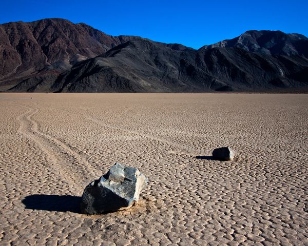
I agree with what others have said about Death Valley...I have been there twice and would go back in a heartbeat...stark and beautiful! If you have a vehicle with high clearance you need to take the 27 mile trip to the Racetrack where the rocks âmoveâ in the dried up lake bed...you might loosen a few fillings in your teeth with the washboard Road getting there but it is well worth it!
Mar 21, 2018 08:25:51 #

art pear wrote:
Heading to the desert of CA in about three weeks. If anyone has any tips on must see sights to photograph I would appreciate it. Thanks.
If you have a good wind storm the place to be is on Mesquite Dunes, especially if it is sunrise or sunset hours. Just be sure to make any lens changes in your car and then not again until you are back in a protected area.
Mar 21, 2018 08:27:21 #
SafariGuy wrote:
I agree with what others have said about Death Valley...I have been there twice and would go back in a heartbeat...stark and beautiful! If you have a vehicle with high clearance you need to take the 27 mile trip to the Racetrack where the rocks âmoveâ in the dried up lake bed...you might loosen a few fillings in your teeth with the washboard Road getting there but it is well worth it!
I've had my Honda CR-V out there three times without any problems. You just have to use your head. I always travel with two full size spare tires in the west, but so far have never had a flat.
I would not try this in a Honda Civic!
Mar 21, 2018 09:56:24 #

I will be in Death Valley on April 10th with my brother who is visiting from Illinois. Maybe we will cross paths. I live in Southern CA and will be coming in from the South.
Mar 21, 2018 12:08:27 #
SierraP
Loc: Eastern Sierras
A lot of good recommendations out there. Don't forget Wildrose Cyn. and the 10-12 beehive charcoal kilns. The site of Ballarat in Panamint Valley. Continue south through Panamint Valley to the south side of Trona. The "Trona Pinnacles" can be very interesting. On the east side of Death Valley is a little island of land that is still part of the park, called Devils Hole. I believe it is in the Ash Meadows area. Devils Hole is an opening to a vast underground lake. You will see one of the rarest fish in the world, the pupfish. About 1 1/2" long and protected by law. If you are coming from Las Vegas, go out Hwy 160 to Pahrump and left on Nevada Hwy 372 to Shoshone. You may see wild burros and wild horses. (they are not people friendly) The Opera House in Shoshone has quite a history. A jog right then the next left will take you into the Park, past the turnoff to Dantes View, later down the road the turnoff to Zabriskie Point. On down the road is the Furnace Creek Inn. (very pricey) A left turn will take you to Badwater and the Devils Golf course. Motels & Food are at the Furnace Creek Ranch, Stovepipe Wells, and Panamint Springs. Sorry to be so long-winded. Do stop at the Headquarters office and get information and a map. This is the nations largest park so distances are far.
Although there are a few gas stations in the park, you will find prices quite high.
Although there are a few gas stations in the park, you will find prices quite high.
Mar 21, 2018 12:14:40 #
SierraP
Loc: Eastern Sierras
Sorry. I didn't notice that you are coming from the south. Think about coming up Hwy 395 to Ridgecrest and then Trona Pinnacles, Panamint Valley and Stovepipe Wells.
Mar 21, 2018 12:21:43 #
I love love love Joshua Tree! Entering from either of the north entrances have many beautiful vistas of rounded rock hills, and a valley with a "forest" of joshua trees. In my imagination, I always expect to see a dinosauer there. Barker Dam trail has good variety. Towards the southern part of the park, the valleys widen and sights are less spectacular. But if the flowers are blooming, you will see meadows closer to Cottonwood. Then its time to look closer to the ground for flower shots.
If you have the time to take in Thousand Palms Oasis on your way back to Palm Springs, its an easy way to walk amongst giant old palms. Enjoy!
If you have the time to take in Thousand Palms Oasis on your way back to Palm Springs, its an easy way to walk amongst giant old palms. Enjoy!
If you want to reply, then register here. Registration is free and your account is created instantly, so you can post right away.