Help with trip to Sedona and Grandcanyon
Sep 17, 2016 14:39:45 #
Hello dear Hedgehogers
This week I'll be traveling to north Arizona, and need ideas where to see and where to shoot some good pictures.
Thank you all in advance
This week I'll be traveling to north Arizona, and need ideas where to see and where to shoot some good pictures.
Thank you all in advance
Sep 17, 2016 15:20:32 #

Look out the windows of your car. There are photo ops everywhere. If you are flying into Phoenix, the minute you start up the hill out of town you will run into photo ops. At the junction of Arizona 89 and I 17 there is the village of Arcosanti. It is an interesting place. Then on north you have Jerome, an old mining town turned artist colony, and state park. Then on further north is Montezuma Well, Sedona, and Flagstaff itself. North of Flagstaff is Waputki/Sunset Crater combo. Go west of Flagstaff to Williams and the Grand Canyon Railroad.
http://arcosanti.org
http://azstateparks.com/Parks/JERO/index.html
http://arcosanti.org
http://azstateparks.com/Parks/JERO/index.html
Sep 17, 2016 15:51:08 #

I'm jealous....4 years ago my husband and I (Aussies), did a similar trip in our little rented van. We had the most brilliant time, and got some good photos of wonderful sights, which are everywhere. If you can manage it, go to Bryce canyon - it's magic. Enjoy your trip, I know you will.
Sep 17, 2016 18:32:37 #

I strongly suggest that you book a Pink Jeep tour of Broken Arrow Canyon. Beautiful scenery, and an enjoyable morning or afternoon. https://www.pinkjeeptourssedona.com/broken-arrow-tour
There are tours of other trails and scenery, but in my opinion, this is the best. I own a 4-WD Dodge Dakota, so my son and I drove this route on our own. We went everywhere the jeeps went.
There are tours of other trails and scenery, but in my opinion, this is the best. I own a 4-WD Dodge Dakota, so my son and I drove this route on our own. We went everywhere the jeeps went.
Sep 17, 2016 19:32:05 #

Sep 18, 2016 07:08:56 #

jethro779 wrote:
Look out the windows of your car. There are photo ... (show quote)
Not familiar with Arcosanti, but enjoyed the other spots. Also, if you do travel west of Flagstaff check out the meteor crater. You could get some good shots in the botanical garden outside of Phoenix, too. I think it's near Scottsdale.
Sep 18, 2016 07:22:27 #

I second the Pink Jeep recommendation but I would avoid the Humvee tours since they are too large for access to some areas. Also, there are helicopter tours - at Sedona, gets you great views of some Pueblo dwellings and at the GC, awesome views East of the main tourist area.
Sep 18, 2016 08:15:20 #
Hooman wrote:
Hello dear Hedgehogers
This week I'll be traveling to north Arizona, and need ideas where to see and where to shoot some good pictures.
Thank you all in advance
This week I'll be traveling to north Arizona, and need ideas where to see and where to shoot some good pictures.
Thank you all in advance
A map and AAA
Sep 18, 2016 08:24:08 #
Get the AAA Indian Country map!! Add Painted Desert - Petrified Forest to your list. Safe travels.
Sep 18, 2016 08:37:18 #

You do not give us much information to work with... How long will you be there? Are you physically fit? From the car you can get all sorts of beautiful shots around Sedona. If you can take short day hikes, there are lots of beautiful ones around Sedona, including the West branch of Oak Creek which is off of a parking area North of town. Get a book "Sedona Day Hikes" (at least three different ones to choose from on Amazon) - you can find lots of isolated beautiful places for your own unique photos. By the way - if you hike - it is very dry - take plenty of water!
The "Pink Jeep" tours are famous. At the Grand Canyon, you will have opportunities for awesome photos at the South Rim, which is where most people go. If you are spending more than a week, then you can check out other areas - Antelope Canyon, the Canyon deChelley, etc.
The "Pink Jeep" tours are famous. At the Grand Canyon, you will have opportunities for awesome photos at the South Rim, which is where most people go. If you are spending more than a week, then you can check out other areas - Antelope Canyon, the Canyon deChelley, etc.
Sep 18, 2016 09:14:51 #

We were in Sedona a few years ago and did this trip - https://www.viator.com/tours/Sedona/Grand-Canyon-West-Rim-Adventure-from-Sedona-Helicopter-Tour-and-Lunch/d750-5630GCWR
Its pricey, but covered a lot of ground. We skipped the skywalk, they would not allow personal cameras. Our particular flight was delayed, so our trip back was close to sunset.
Its pricey, but covered a lot of ground. We skipped the skywalk, they would not allow personal cameras. Our particular flight was delayed, so our trip back was close to sunset.
Sep 18, 2016 09:50:12 #

Agree with all of the above. If time permits I would add Horseshoe Bend outside of Page (can be done while including Antelope Canyon tours) and, if you want to venture to the far north, I would not miss seeing Monument Valley.
Sep 18, 2016 09:53:26 #

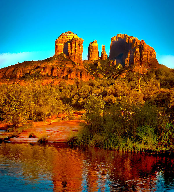
Sedona is my favorite place to go for photo opts. Sun rise and sun sets are the best times to get the deep red in the Red Rock country Cathedral Rock is in Oak Creek just outside of Sedona. Just a short walk from the parking area down a dirt path. Bring a tripod for best results
Sep 18, 2016 10:10:48 #
ALN
Loc: San Diego, CA
jethro779 wrote:
Look out the windows of your car. There are photo ... (show quote)
On this route, you will also pass Nothing, AZ - another photo op. But don't blink as you approach iy or you will miss it! https://en.wikipedia.org/wiki/Nothing,_Arizona
Sep 18, 2016 12:25:31 #
This week I'll be traveling to north Arizona, and need ideas where to see and where to shoot some good pictures.
Thank you all in advance[/quote]
sorry for typos...
I spend a lot of time in Sedona....
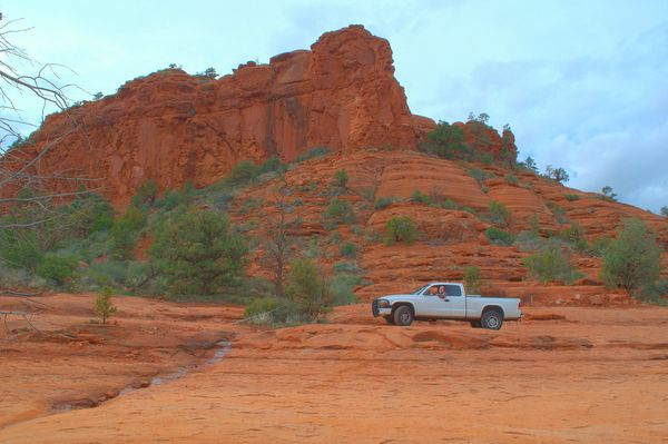
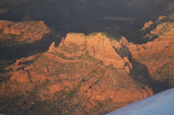
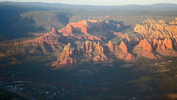
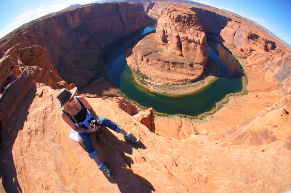
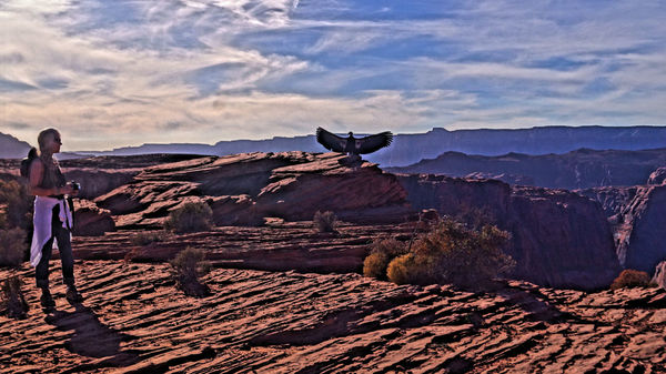
BELOW ARE SOME MAPS AND OVERVIEW IMAGES ...THE ONES ON THE GROUND are some of the thousands of photos I have taken there in the last few years...I have included two from the Horseshoe Bend near Page, AZ and one kind of lucky shot since a condor landed right there and I guess to cool off spread its huge wings....The lighting was very contrasty so I elected to use the in camera HDR on my Sony to get the shadows and the cirrus clouds...It kept its wings spread for about 40 seconds so I was able to frame this a bit..
At the Grand Canyon the next day we talked to a ranger and we described what we had seen and gave her the tag number that was visible. She was concerned that it was unafraid of human proximity since I guess there are people out among us who will poach or just kill them .....the ranger said they want the condors to be wary/afraid of humans rather than trusty and exhibiting tame behavior. Oh well....this was an extraordinary moment no matter what between a two beautiful creatures!!!
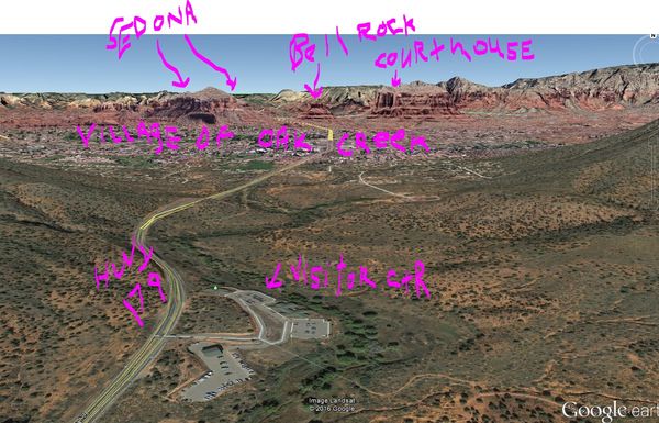
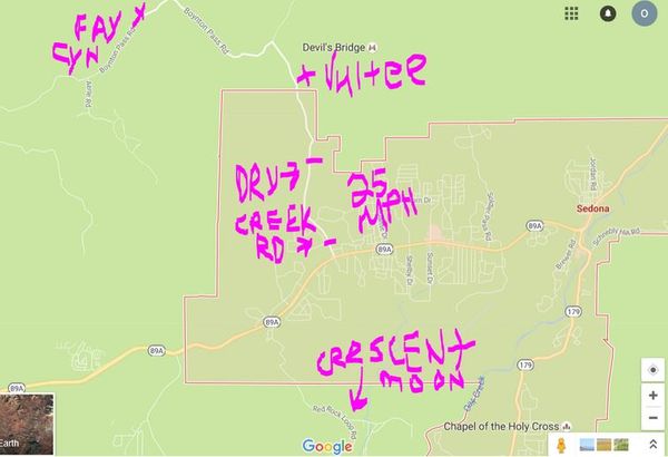
The best place in Sedona is called Crescent Moon Ranch Park...a private concession runs this for the park service...The most iconic photos of Sedona are done there....there is a beautiful flat red rock "beach" next to Oak Creek and there is an upper plateau overlook that has a nearly obscured trail head by some electric transformers about 150 yards from the front entrance. Just ask the attendant in the entrance booth where the trail head is and she will tell you... it is two minutes from the booth but very hidden.....This upper plateau is a famous SEDONA VORTEX site and so once in a while you will see groups of people led by a guru person to do chant and meditate... Otherwise it is pretty empty...I have one photo below from the upper plateau ....The fall colors in October of 2014 were so beautiful...
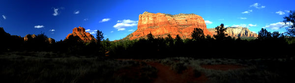
The panorama image is of Courthouse Butte and Bell Rock...there is a south parking lot and a north parking lot re Bell Rock..There is a matrix of easy to hike trails around both Bell Rock and Courthouse Butte that are well worth doing...all trails are very well marked ....The varied cloud cover of course enhances any photographs in Sedona/ the entire Southwest for that matter....
DON'T GIVE UP FINDING CRESCENT MOON RANCH!!!! THE ROAD GETS CONFUSING AND PEOPLE END UP GOING TO RED ROCK STATE PARK A FEW MILES FURTHER ON THIS LOOP ROAD COMING OUT OF HIGHWAY 89A....DON'T GIVE UP!!!
Beware of big game on all roads at night!!!!!!
There are of course so many things to see in this general area....up by Page is the Horseshoe Bend of the Colorado River, upper Antelope Canyon, Hopi Mesa 1, 2, 3, Meteor Crater, Walnut Canyon cliff dwellings just a few miles east of Flagstaff off of I-40, Sunset Crater, Lowell Observatory in Flagstaff where Pluto was discovered, Cameron Trading Post on Highway 89 (have the Navajo stew), La Posada Hotel in Winslow near the Standing on the Corner Eagles song site, Little Painted Desert overlook near Winslow, The Painted Desert east of Holbrook, the Petrified Forest both the part near I-40 and to the south entrance..which is different than the visitor center next to I-40, the Wupatki Nation Monument (you can do a loop east of 89 to take in the Wupatki ruins and the Sunset Craters..
La Posada Hotel in Winslow
http://www.laposada.org/
Lowell Observatory in FLG
https://lowell.edu/
Near Winslow is Art Rock Ranch..I have done this tour twice....if you pay once, Baird doesn't charge for subsequent tours....this is a MUST see/MUST do thing....It is listed in AAA tour books....Baird is an original....Must see/Must do.
http://www.sunset.com/travel/southwest/southwest-sights/
Cameron Trading Post...Little Colorado overlooks are just a few miles west of here on the road to the Grand Canyon east entrance (Desert View).
https://www.camerontradingpost.com/
Walnut Canyon National Monument | Flagstaff AZ Indian Ruins - Arizona
www.arizona-leisure.com/walnut-canyon.html
Jun 28, 2014 - Arizona Resorts & Spas. Canyon de Chelly. Casa Grande Ruins. Montezuma Castle. Montezuma Well. Palatki Indian Ruins. Pueblo Grande Ruins. Walnut Canyon. Wupatki Indian Ruins.
Ancient Indian Ruins & Cliff Dwellings | Flagstaff Special Edition | Art ...
flagstaffspecialedition.com/ancient-indian-ruins-cliff-dwellings/
Ancient Indian Ruins & Cliff Dwellings. If you have a fascination with old ruins and ancient cultures, there is no better place in Arizona to base yourself than in the ...
Wupatki National Monument (U.S. National Park Service)
https://www.nps.gov/wupa/
National Park Service
Mailing Address: 6400 U.S. 89. Flagstaff, AZ 86004. Phone: (928) 679-2365. Phones are answered during visitor center hours between 9:00 a.m. and 5:00 p.m. ...
Sunset Crater Volcano National Monument (U.S. National Park Service)
https://www.nps.gov/sucr/
National Park Service
Plan Your Visit - Sunset Crater Volcano National Monument (U.S. ...
https://www.nps.gov/sucr/planyourvisit/
National Park Service
Most visitors drive through the 34 mile scenic loop that winds from Highway 89 through Sunset Crater Volcano and Wupatki National Monuments. The scenic ...
Sunset Crater - Wikipedia, the free encyclopedia
https://en.wikipedia.org/wiki/Sunset_Crater
Wikipedia
Sunset Crater is a cinder cone located north of Flagstaff in U.S. State of Arizona. The crater is within the Sunset Crater Volcano National Monument. Sunset
re Sedona and Crescent Moon Ranch Park......the upper plateau there is a famous SEDONA VORTEX site and so once in a while you will see groups of people led by a guru person to do chants and meditate... Otherwise it is pretty empty because nobody but the locals go up there...the trail is easy and takes 15 minutes or less from the road to the top but there are numerous places to take photos on this will marked trail using rocks in thick chicken wire as markers.. So if you go there, make SURE you do the upper plateau ...there is a lone cactus atop that is in postcards, calendars galore but as a visitor you would be hard pressed to find the spot..
here is a good link
http://redrockrealty.net/red-rock-crossing/
in mid October or so, the trees change dramatically in Crescent Moon Ranch which is just jaw dropping re the red rock backdrop.......a moonrise at Crescent Moon Ranch leaves you speechless..The amount of tourists from October to April is way down so you have much of this to yourself...
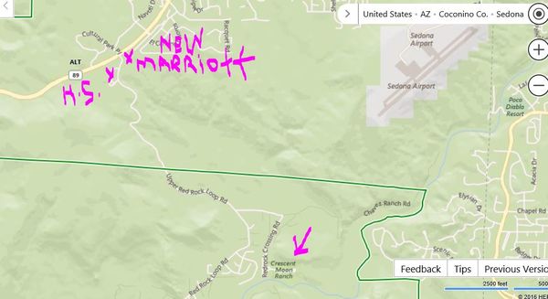
There are several areas with magnificent reflecting pools where Oak Creek slows down. The afternoon to sunset light is best on Cathedral Rock which dominates the backdrop at Crescent Moon Ranch Park... This park is not widely known as you would think since you have to drive on a road off of 89A where the high school is on the south corner and a new Courtyard by Marriott is on the north corner....and the Summit Diamond Resort is on the west corner... This is all on the west side of Sedona ....But you go down the hill and and make a few turns and you are there.
Crescent Moon is NOT to be confused with Red Rock State Park... Some of the most famous photos of Sedona/Cathedral Rock are taken from both the lower and upper part of Crescent Moon Ranch...If you cannot find the trail head to the upper plateau, ask the person in the entry kiosk and they will direct you to it since it is on the street and not inside the park ...so it is kind of odd. The locals use this park as kind of their own so it is constantly overlooked by most visitors .....There are several reflecting pool areas and one of the best is just after you pass the kiosk where you will find parking and picnic tables and a restroom....if you take the paved path to the right of the restroom for about 150 yards, you will come to where you can see Oak Creek...you just go down a little berm and there is a little jut of land that changes due to the river from time to time but usually there are photographers there....
Cathedral Rock is quite high so it captures light well after the base area grows dark...This is so wonderful because Oak Creek then becomes almost a black mirror to capture the refection of Cathedral Rock ....and Cathedral Rock glows at sunset and then continues to have a beautiful illumination in the after glow period after the sunset...High clouds at that time of evening act as reflector umbrellas to add a glow that can be picked up in the reflections off of the Oak Creek....For me the real magic of that place is in the early evening.... You can sustain photo taking by using in camera HDR if you have that like I do on the Sonys I use... I have gone quite a few places on this planet including Antarctica but Crescent Moon Ranch is my favorite place on earth...
There is a large visitor center after you turn off I-17 and go north on 179 which takes you into the Village of Oak Creek and then eventually into the bustling city of Sedona.. You can get that pass there and maps..This is a must STOP place. So just be aware that any public land area you go to in Sedona you usually must have Red Rock pass or display your National Park Annual Pass or you can be ticketed in any of the turnouts or other roads..
There are two parking areas at Bell Rock...one on the Village of Oak Creek side and one on the north side of Bell Rock....there are very easy to do trails there around Bell Rock and Courthouse Butte..
Be advised there are about 9 to 11 roundabouts starting in the Village of Oak Creek to the center of Sedona....If you re not used to roundabouts aka traffic circles it can be a bit daunting since the locals zip through them quite fast while outsiders kind of become tentative ....so you have to deal with it cautiously and if you are used to driving in the English style, you might have to think it through a bit.....The general rule is the traffic on YOUR LEFT side has the right away coming around the circle.... But it is something to consider. They spent quite a few years building these roundabouts on HWY 179 and other road construction which is now thank God finished!!!
Now there are many, many more places I could put in here ..The trails around Bell Rock, Crescent Moon Ranch Park, Dry Creek Road to the Vultee parking lot, and eventually Fay Canyon are pretty much what I really like there ...
There is another approach to the area across OAK CREEK at Crescent Moon Ranch but you have to take Verde Valley School Road from the Village of Oak Creek to get to that opposite bank of Oak Creek unless the crossing area rocks are in place or you are brave enough to wade to the other side.....But on that other side is a trail and side path to a great shot of the Cathedral Rock..This is very difficult to describe but you can see the beach area across Oak Creek but to get to that place and have a better angle of Cathedral Rock you have to hike in the dry area of the Oak Creek (not in flood times) to be on that opposite bank...There is a trail but you have to find that side trail by looking at landmarks around you...
The area around the Vultee parking lot of of Dry Creek Road is just so beautiful because it gives you a panoramic view of a "long valley" with the exposed southern face the Colorado Plateau in front of you for miles....So don't miss this stop off of Dry Creek Road.. When you turn north off of 89A onto Dry Creek Road, the speed limit goes down to 25 MPH!!! This is an almost impossible speed to keep until it clears the housing area....The main point is the police hawk around this speed trap area so make sure you do 25MPH....the Pink Jeep Tour people take this road to get to dirt roads NW of Sedona...
There is an eastern approach to Cathedral Rock right off Highway 179 by turning off at Back O' Beyond Rd down the hill to a parking lot ....There you can do some trails up on the eastern flank of Cathedral Rock...This parking lot does fill up so you might have to park in another lot on 179 and thus have a steep walk back up after you are finished.
One big political thing going on here in this whole area is the battle between developers and the National Park Service. Had this been discovered today, the entire area would have been made a national park from the top of Oak Creek Canyon to about 6 miles south Bell Rock...The NPS or whoever the overseeing administration is now is threatens to make the entire area protected land which could mean the confiscation of private property. The development in the last 25 years has been extraordinary even if this was a totally urban area around a big city. People have built on top of buttes....right up to the bases of the most spectacular and unique topographic features on the planet ....
It is impossible to take a photo now without the inclusion of houses so in PSE one is busy using the erasure tool to blend in things... It is one thing to develop along 89A and the 179 but quite another leap of environmental impact to do what they are doing now.....Those who thought their view was the best now have taken the back rows to others who have developed in front of their view and so on and so on... Other than the many parts of the California coast line, there has never been this kind of inconsiderate changes done in America. Sedona is like being in the Grand Canyon since this is the southern exposed flank of the Colorado Plateau ..so what is in Sedona so easily exposed is what the Colorado River took a long time to unearth...
Who knows what the Federal Govt will eventually do to put a stop to this development which is destroying the very reason why people visit there.....to the point the souvenir shops and galleries block out the view of the very things they reproduce to sell.
I suppose we are all part of the problem but this has now has reached a tipping point.....that they have gone too far which displeases the original people/families who bought there in the 50's and 60's as well as visitors who have come there for decades and saw the ghastly alterations. In the late 1950's, they built the Chapel of the Holy Cross which is still there....and I suppose that started the downward slide though it is a nice looking structure...Today if you stand on the west side of that church and look directly down, you see a pinkish mansion with a big swimming pool that looks like it is straight out of Bel Air in the Hollywood Hills of Los Angeles...
http://www.chapeloftheholycross.
I feel like it is an region you had better see now before it is forever altered and becomes inaccessible due to the private property lines. One suspects that there is a lot of BLM and State lands that has been bartered away through legislation/special deals since much of this is/was in public trust..
Thank you all in advance[/quote]
sorry for typos...
I spend a lot of time in Sedona....
BELOW ARE SOME MAPS AND OVERVIEW IMAGES ...THE ONES ON THE GROUND are some of the thousands of photos I have taken there in the last few years...I have included two from the Horseshoe Bend near Page, AZ and one kind of lucky shot since a condor landed right there and I guess to cool off spread its huge wings....The lighting was very contrasty so I elected to use the in camera HDR on my Sony to get the shadows and the cirrus clouds...It kept its wings spread for about 40 seconds so I was able to frame this a bit..
At the Grand Canyon the next day we talked to a ranger and we described what we had seen and gave her the tag number that was visible. She was concerned that it was unafraid of human proximity since I guess there are people out among us who will poach or just kill them .....the ranger said they want the condors to be wary/afraid of humans rather than trusty and exhibiting tame behavior. Oh well....this was an extraordinary moment no matter what between a two beautiful creatures!!!
The best place in Sedona is called Crescent Moon Ranch Park...a private concession runs this for the park service...The most iconic photos of Sedona are done there....there is a beautiful flat red rock "beach" next to Oak Creek and there is an upper plateau overlook that has a nearly obscured trail head by some electric transformers about 150 yards from the front entrance. Just ask the attendant in the entrance booth where the trail head is and she will tell you... it is two minutes from the booth but very hidden.....This upper plateau is a famous SEDONA VORTEX site and so once in a while you will see groups of people led by a guru person to do chant and meditate... Otherwise it is pretty empty...I have one photo below from the upper plateau ....The fall colors in October of 2014 were so beautiful...
The panorama image is of Courthouse Butte and Bell Rock...there is a south parking lot and a north parking lot re Bell Rock..There is a matrix of easy to hike trails around both Bell Rock and Courthouse Butte that are well worth doing...all trails are very well marked ....The varied cloud cover of course enhances any photographs in Sedona/ the entire Southwest for that matter....
DON'T GIVE UP FINDING CRESCENT MOON RANCH!!!! THE ROAD GETS CONFUSING AND PEOPLE END UP GOING TO RED ROCK STATE PARK A FEW MILES FURTHER ON THIS LOOP ROAD COMING OUT OF HIGHWAY 89A....DON'T GIVE UP!!!
Beware of big game on all roads at night!!!!!!
There are of course so many things to see in this general area....up by Page is the Horseshoe Bend of the Colorado River, upper Antelope Canyon, Hopi Mesa 1, 2, 3, Meteor Crater, Walnut Canyon cliff dwellings just a few miles east of Flagstaff off of I-40, Sunset Crater, Lowell Observatory in Flagstaff where Pluto was discovered, Cameron Trading Post on Highway 89 (have the Navajo stew), La Posada Hotel in Winslow near the Standing on the Corner Eagles song site, Little Painted Desert overlook near Winslow, The Painted Desert east of Holbrook, the Petrified Forest both the part near I-40 and to the south entrance..which is different than the visitor center next to I-40, the Wupatki Nation Monument (you can do a loop east of 89 to take in the Wupatki ruins and the Sunset Craters..
La Posada Hotel in Winslow
http://www.laposada.org/
Lowell Observatory in FLG
https://lowell.edu/
Near Winslow is Art Rock Ranch..I have done this tour twice....if you pay once, Baird doesn't charge for subsequent tours....this is a MUST see/MUST do thing....It is listed in AAA tour books....Baird is an original....Must see/Must do.
http://www.sunset.com/travel/southwest/southwest-sights/
Cameron Trading Post...Little Colorado overlooks are just a few miles west of here on the road to the Grand Canyon east entrance (Desert View).
https://www.camerontradingpost.com/
Walnut Canyon National Monument | Flagstaff AZ Indian Ruins - Arizona
www.arizona-leisure.com/walnut-canyon.html
Jun 28, 2014 - Arizona Resorts & Spas. Canyon de Chelly. Casa Grande Ruins. Montezuma Castle. Montezuma Well. Palatki Indian Ruins. Pueblo Grande Ruins. Walnut Canyon. Wupatki Indian Ruins.
Ancient Indian Ruins & Cliff Dwellings | Flagstaff Special Edition | Art ...
flagstaffspecialedition.com/ancient-indian-ruins-cliff-dwellings/
Ancient Indian Ruins & Cliff Dwellings. If you have a fascination with old ruins and ancient cultures, there is no better place in Arizona to base yourself than in the ...
Wupatki National Monument (U.S. National Park Service)
https://www.nps.gov/wupa/
National Park Service
Mailing Address: 6400 U.S. 89. Flagstaff, AZ 86004. Phone: (928) 679-2365. Phones are answered during visitor center hours between 9:00 a.m. and 5:00 p.m. ...
Sunset Crater Volcano National Monument (U.S. National Park Service)
https://www.nps.gov/sucr/
National Park Service
Plan Your Visit - Sunset Crater Volcano National Monument (U.S. ...
https://www.nps.gov/sucr/planyourvisit/
National Park Service
Most visitors drive through the 34 mile scenic loop that winds from Highway 89 through Sunset Crater Volcano and Wupatki National Monuments. The scenic ...
Sunset Crater - Wikipedia, the free encyclopedia
https://en.wikipedia.org/wiki/Sunset_Crater
Wikipedia
Sunset Crater is a cinder cone located north of Flagstaff in U.S. State of Arizona. The crater is within the Sunset Crater Volcano National Monument. Sunset
re Sedona and Crescent Moon Ranch Park......the upper plateau there is a famous SEDONA VORTEX site and so once in a while you will see groups of people led by a guru person to do chants and meditate... Otherwise it is pretty empty because nobody but the locals go up there...the trail is easy and takes 15 minutes or less from the road to the top but there are numerous places to take photos on this will marked trail using rocks in thick chicken wire as markers.. So if you go there, make SURE you do the upper plateau ...there is a lone cactus atop that is in postcards, calendars galore but as a visitor you would be hard pressed to find the spot..
here is a good link
http://redrockrealty.net/red-rock-crossing/
in mid October or so, the trees change dramatically in Crescent Moon Ranch which is just jaw dropping re the red rock backdrop.......a moonrise at Crescent Moon Ranch leaves you speechless..The amount of tourists from October to April is way down so you have much of this to yourself...
There are several areas with magnificent reflecting pools where Oak Creek slows down. The afternoon to sunset light is best on Cathedral Rock which dominates the backdrop at Crescent Moon Ranch Park... This park is not widely known as you would think since you have to drive on a road off of 89A where the high school is on the south corner and a new Courtyard by Marriott is on the north corner....and the Summit Diamond Resort is on the west corner... This is all on the west side of Sedona ....But you go down the hill and and make a few turns and you are there.
Crescent Moon is NOT to be confused with Red Rock State Park... Some of the most famous photos of Sedona/Cathedral Rock are taken from both the lower and upper part of Crescent Moon Ranch...If you cannot find the trail head to the upper plateau, ask the person in the entry kiosk and they will direct you to it since it is on the street and not inside the park ...so it is kind of odd. The locals use this park as kind of their own so it is constantly overlooked by most visitors .....There are several reflecting pool areas and one of the best is just after you pass the kiosk where you will find parking and picnic tables and a restroom....if you take the paved path to the right of the restroom for about 150 yards, you will come to where you can see Oak Creek...you just go down a little berm and there is a little jut of land that changes due to the river from time to time but usually there are photographers there....
Cathedral Rock is quite high so it captures light well after the base area grows dark...This is so wonderful because Oak Creek then becomes almost a black mirror to capture the refection of Cathedral Rock ....and Cathedral Rock glows at sunset and then continues to have a beautiful illumination in the after glow period after the sunset...High clouds at that time of evening act as reflector umbrellas to add a glow that can be picked up in the reflections off of the Oak Creek....For me the real magic of that place is in the early evening.... You can sustain photo taking by using in camera HDR if you have that like I do on the Sonys I use... I have gone quite a few places on this planet including Antarctica but Crescent Moon Ranch is my favorite place on earth...
There is a large visitor center after you turn off I-17 and go north on 179 which takes you into the Village of Oak Creek and then eventually into the bustling city of Sedona.. You can get that pass there and maps..This is a must STOP place. So just be aware that any public land area you go to in Sedona you usually must have Red Rock pass or display your National Park Annual Pass or you can be ticketed in any of the turnouts or other roads..
There are two parking areas at Bell Rock...one on the Village of Oak Creek side and one on the north side of Bell Rock....there are very easy to do trails there around Bell Rock and Courthouse Butte..
Be advised there are about 9 to 11 roundabouts starting in the Village of Oak Creek to the center of Sedona....If you re not used to roundabouts aka traffic circles it can be a bit daunting since the locals zip through them quite fast while outsiders kind of become tentative ....so you have to deal with it cautiously and if you are used to driving in the English style, you might have to think it through a bit.....The general rule is the traffic on YOUR LEFT side has the right away coming around the circle.... But it is something to consider. They spent quite a few years building these roundabouts on HWY 179 and other road construction which is now thank God finished!!!
Now there are many, many more places I could put in here ..The trails around Bell Rock, Crescent Moon Ranch Park, Dry Creek Road to the Vultee parking lot, and eventually Fay Canyon are pretty much what I really like there ...
There is another approach to the area across OAK CREEK at Crescent Moon Ranch but you have to take Verde Valley School Road from the Village of Oak Creek to get to that opposite bank of Oak Creek unless the crossing area rocks are in place or you are brave enough to wade to the other side.....But on that other side is a trail and side path to a great shot of the Cathedral Rock..This is very difficult to describe but you can see the beach area across Oak Creek but to get to that place and have a better angle of Cathedral Rock you have to hike in the dry area of the Oak Creek (not in flood times) to be on that opposite bank...There is a trail but you have to find that side trail by looking at landmarks around you...
The area around the Vultee parking lot of of Dry Creek Road is just so beautiful because it gives you a panoramic view of a "long valley" with the exposed southern face the Colorado Plateau in front of you for miles....So don't miss this stop off of Dry Creek Road.. When you turn north off of 89A onto Dry Creek Road, the speed limit goes down to 25 MPH!!! This is an almost impossible speed to keep until it clears the housing area....The main point is the police hawk around this speed trap area so make sure you do 25MPH....the Pink Jeep Tour people take this road to get to dirt roads NW of Sedona...
There is an eastern approach to Cathedral Rock right off Highway 179 by turning off at Back O' Beyond Rd down the hill to a parking lot ....There you can do some trails up on the eastern flank of Cathedral Rock...This parking lot does fill up so you might have to park in another lot on 179 and thus have a steep walk back up after you are finished.
One big political thing going on here in this whole area is the battle between developers and the National Park Service. Had this been discovered today, the entire area would have been made a national park from the top of Oak Creek Canyon to about 6 miles south Bell Rock...The NPS or whoever the overseeing administration is now is threatens to make the entire area protected land which could mean the confiscation of private property. The development in the last 25 years has been extraordinary even if this was a totally urban area around a big city. People have built on top of buttes....right up to the bases of the most spectacular and unique topographic features on the planet ....
It is impossible to take a photo now without the inclusion of houses so in PSE one is busy using the erasure tool to blend in things... It is one thing to develop along 89A and the 179 but quite another leap of environmental impact to do what they are doing now.....Those who thought their view was the best now have taken the back rows to others who have developed in front of their view and so on and so on... Other than the many parts of the California coast line, there has never been this kind of inconsiderate changes done in America. Sedona is like being in the Grand Canyon since this is the southern exposed flank of the Colorado Plateau ..so what is in Sedona so easily exposed is what the Colorado River took a long time to unearth...
Who knows what the Federal Govt will eventually do to put a stop to this development which is destroying the very reason why people visit there.....to the point the souvenir shops and galleries block out the view of the very things they reproduce to sell.
I suppose we are all part of the problem but this has now has reached a tipping point.....that they have gone too far which displeases the original people/families who bought there in the 50's and 60's as well as visitors who have come there for decades and saw the ghastly alterations. In the late 1950's, they built the Chapel of the Holy Cross which is still there....and I suppose that started the downward slide though it is a nice looking structure...Today if you stand on the west side of that church and look directly down, you see a pinkish mansion with a big swimming pool that looks like it is straight out of Bel Air in the Hollywood Hills of Los Angeles...
http://www.chapeloftheholycross.
I feel like it is an region you had better see now before it is forever altered and becomes inaccessible due to the private property lines. One suspects that there is a lot of BLM and State lands that has been bartered away through legislation/special deals since much of this is/was in public trust..
(Download)
(Download)
(Download)
(Download)
(Download)
(Download)
(Download)
(Download)
(Download)
(Download)
If you want to reply, then register here. Registration is free and your account is created instantly, so you can post right away.